Wabun, Virginia
| Wabun, Virginia | |
|---|---|
| Unincorporated community | |
  Location within the Commonwealth of Virginia | |
| Coordinates: 37°14′56″N 80°08′29″W / 37.24889°N 80.14139°WCoordinates: 37°14′56″N 80°08′29″W / 37.24889°N 80.14139°W | |
| Country | United States |
| State | Virginia |
| County | Roanoke |
| Elevation | 1,099 ft (335 m) |
| Time zone | Eastern (EST) (UTC-5) |
| • Summer (DST) | EDT (UTC-4) |
| ZIP code | 24153 |
| Area code(s) | 540 |
| GNIS feature ID | 1494287[1] |
| USGS[2] | |
Wabun is an unincorporated community in western Roanoke County, Virginia, United States. The community lies along the Roanoke River and near the base of Poor Mountain.[3]
References
- ↑ "US Board on Geographic Names". United States Geological Survey. 2007-10-25. Retrieved 2008-01-31.
- ↑ USGS. "Geographic Names Information System Feature Detail Report: Wabun". Retrieved 2008-08-06.
- ↑ "Google Maps". Retrieved 2008-08-06.
Municipalities and communities of Roanoke County, Virginia, United States | ||
|---|---|---|
| Town | 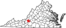 | |
| CDPs | ||
| Unincorporated communities | ||
| Footnotes | ‡This populated place also has portions in an adjacent county or counties | |
This article is issued from Wikipedia - version of the 11/10/2016. The text is available under the Creative Commons Attribution/Share Alike but additional terms may apply for the media files.