Voorhout
| Voorhout | ||
|---|---|---|
| ||
| Coordinates: 52°13′23″N 4°29′11″E / 52.22306°N 4.48639°E | ||
| Country | Netherlands | |
| Province | South Holland | |
| Municipality | Teylingen | |
| Population (2005) | 14.972 | |
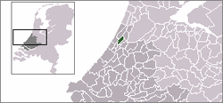

Voorhout (Dutch pronunciation: [ˈvoːrɦʌut]) is a town and former municipality in the western Netherlands, in the province of South Holland. The former municipality covered an area of 12.59 km² (4.86 mile²) of which 0.33 km² (0.13 mile²) is covered by water, and had a population of 14,792 in 2004. Together with Sassenheim and Warmond, it became part of the Teylingen municipality on 1 January 2006. Voorhout is located in an area called the "Dune and Bulb Region" (Duin- en Bollenstreek).
It also included the communities of Piet Gijzenbrug (partly) and Teijlingen with the Slot Teylingen.
History
For hundreds of years Voorhout was just a dot on the map. In 1988 Voorhout celebrated its thousand years of existence. The exact year is not known, but it is sure that its early name was Foranholte, and it lay in a big woody area and stretched from Lisse to Oegstgeest and from Katwijk to Sassenheim. Qua area it could compete with Leiden. Voorhout had few inhabitants, only a few hundred, mostly farmers. There was no real village centre, not until a few years before the 19th century. During the end 80s and the 90s Voorhout becomes a bigger town with new districts like Hoogh Teylingen and a VINEX-town to the west during the 2000s. The population reached over the 10.000 inhabitants.
Born in Voorhout
- Herman Boerhaave (31 December 1668 - 23 September 1738), botanist, humanist and physician of European fame
- Karlijn Kranenburg, a clay artist known for his contribution to the production of claylike erasers
- Job Musters
- Edwin van der Sar (29 October 1970), football player (goalkeeper)
- Rob van Dijk (15 January 1969), football player (goalkeeper)
Lived in Voorhout
- Jacqueline of Bavaria (Le Quesnoy, 16 July 1401 – Slot Teylingen, 9 October 1436), Countess of Holland, lived for a few years in Slot Teylingen
- Carlo l'Ami, old football player (goalkeeper) and later goalkeeper's trainer by AFC Ajax, in Amsterdam
- Job Musters, football player, started his career at FC Foreholte.
- Joris Schouten (Blokker, 23 September 1926), politician
- Chiara Tissen (5 March 1964), actress and writer
- E.M. Uhlenbeck (Den Haag, 9 August 1913 - Voorhout, 27 May 2003), linguist
- Truus van Aalten (Arnhem, 2 August 1910 - Warmond, 27 June 1999), actress, she ran a souvenir import/export business in Voorhout after 1954, after the Nazis ended her career as a film comedian in Germany
- Marco van Basten, former football player (Striker) and later a coach at AFC Ajax, SC Heerenveen and AZ Alkmaar
- Frank van Borssele (1395–1470), Stadholder (Governor) of Holland and Zeeland provinces, Count of Oostervant, fourth husband of Jacoba van Beieren, lived for a few years in Slot Teylingen
- Edwin van der Sar (29 October 1970), goalkeeper for AFC Ajax, Juventus, Fulham, Manchester United and the National team, started career at VV Foreholte
Sights
- Mill Hope Brings Life, in Dutch: Poldermolen Hoop Doet Leven (monument)
- Panorama Tulipland
- Teylingen Castle
External links
Coordinates: 52°13′23″N 4°29′11″E / 52.22306°N 4.48639°E