Virugambakkam
| Virugambakkam விருகம்பாக்கம் | |
|---|---|
| neighbourhood | |
 Virugambakkam  Virugambakkam  Virugambakkam | |
| Coordinates: 13°02′58″N 80°11′06″E / 13.049557°N 80.184928°ECoordinates: 13°02′58″N 80°11′06″E / 13.049557°N 80.184928°E | |
| Country | India |
| State | Tamil Nadu |
| District | Chennai |
| Metro | Chennai |
| Elevation | 17 m (56 ft) |
| Languages | |
| • Official | Tamil |
| Time zone | IST (UTC+5:30) |
| PIN | 600092 |
| Vehicle registration | TN-10 |
| Lok Sabha constituency | Chennai South |
| Vidhan Sabha constituency | Virugambakkam |
Virugambakkam is a residential neighbourhood of Chennai, Tamil Nadu, India. It is an important residential area and is famous for its schools, market, residential colonies and residences of film artists. Virugambakkam had some of Chennai's oldest film studios.
Virugambakkam is one of the important localities of Chennai and owes its growth to the expansion of the city in the post-independence period. Prior to the establishment of residential colonies, Virugambakkam was a village covered by paddy fields, mangoe orchards and casurina trees.. Virugambakkam was first included within the Chennai city limits in 1977 along with other villages like Saligramam.
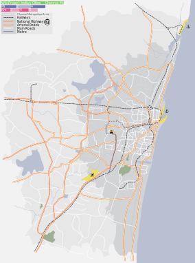
Virugambakkam is well-connected with the heart of Chennai city through roads. Buses running through Arcot Road link Virugambakkam with the more inner suburbs of Chennai city.
Location
Virugambakkam is situated at a distance of 12 kilometres from Fort St George and 10 kilometres from Poonamallee. It is bound by Saligramam in the east, Koyambedu to the north and Alwarthirunagar to the west and south-west and K.K. Nagar and Ramavaram, Tamil Nadu to the south-east. Its frontier with Alwarthirunagar forms the western limits of the Corporation of Chennai.
History
The growth of Virugambakkam accompanied the expansion of Madras city during the years preceding independence. Virugambakkam was one of the many localities which cropped up during the Second World War. At that time, it was a part of the Kodambakkam-Saligramam-Puliyur residential district of Greater Madras.[1][2] During the 1940s, Arcot Road was constructed connecting Nungambakkam with the Mount-Poonamallee Road. In 1948, the first movie studios made their appearance when Avichi Meiyappa Chettiar shifted his base from Karaikudi.[3] The locality has since become a haven for movie producers and cine artists.[4][5]
Virugambakkam was one of the important places connected with the Anti-Hindi agitations of 1965. Aranganathan, a 32-year-old employee with the Indian Postal Service immolated himself in protest against the imposition of Hindi.[6] The Dravida Munnetra Kazhagam vigorously campaigned in the Virugambakkam region during the 1967 elections.[7] Dravida Munnetra Kazhagam has done a 1st state level meeting it has been organised by V.P Akilan. the meeting has been held in front of Arignar Anna,Karunanithi,M.G Ramachandran and some leaders in Dravida Munnetra Kazhagam
Till the 1970s, Virugambakkam was little more than an insignificant village. It formed a part of Saidapet taluk of Chengleput district. Apart from a few movie studios, there were only a few sparsely populated settlements. The interior area which makes up the middle-class residential colonies were covered by paddy fields. The town had a population of 8,013 in 1971. During those times, the outlying suburbs of the city alongside Arcot Road had a reputation for insecurity and as the haunt of sex.[8] Till the early 1970s, the suburb of Kodambakkam formed the western frontier of Madras city. Virugambakkam was included in Madras city in 1973 along with Saligrammam. Since then, growth has accelerated peaking in the 1980s and 1990s.[8] The good quality of ground water available in the Arcot Road suburbs was an important reason for the region's growth.[8]
Geography
The soil is fertile and productive as is evident from the fact that paddy fields once covered the area. However, paddy fields have completely disappeared. Natural gas was discovered near Virugambakkam in 1966.[9] Till date, Virugambakkam is the only known source of natural gas in Chennai city apart from Avadi.[9]
The Virugambakkam Canal separates Virugambakkam from suburbs such as Koyambedu, which lie towards the interior.[10][11] The canal runs for about 6 kilometres through the suburbs of Choolaimedu, Arumbakkam and Vadapalani before entering Virugambakkam.[10][12] This canal originally served the purpose of irrigating farm lands.[10] However, with the transformation of farmlands into residential localities, the canal has been converted into a drain.[10] During the monsoons, the canal frequently overflows creating havoc for the residents of the nearby areas.[12] In 2003, desilting work was carried out to deal with the situation.[12]
Localities
Virugambakkam extends for about 2 kilometres from Avichi Higher Sec.School in Arcot Road to Valasarawakkam. Virugambakkam extends alongside Arcot Road adjacent to Saligrammam in the East, Valasaravakkam in the west, Koyambedu in the north and KK Nagar in the South. State Bank Colony and Baskar Colony are some of the important residential areas in the neighbourhood. Kaaliamman Koil Street which connects Virugambakkam and Koyambedu,Arcot Road are the main arterial roads.
Important landmarks

Virugambakkam is known for its movie studios and schools. It is also the home to a large number of film actors, music composers and other artists. The Virugambakkam market which lies to the west is a source for fresh vegetables. Some important temples are Vembuliamman Koil, Kaliamman Koil and Raghavendra temple, Sankarashramam-Sri Raja Rajeswari Temple, Hari Hara Temple, Siva Vishnu Temple. There is also a mosque and numerous churches. Virugambakkam also has a number of hospitals which along with the schools and departmental stores cater to the needs of the residential colonies. Virugambakkam RTO Office located at Chinmayanagar on Kaliamman Koil Street. There are also more number of Nationalised & Private Banks.[13][14]
Educational institutions
Schools
- Avichi Higher Secondary School
- Chinmaya Vidyalaya ,virugambakkam
- A. V. M. Matriculation Higher Secondary School
- Balalok Matriculation Higher Secondary School
- Clarence Matriculation
- Little Millennium (Educomp) for pre-schoolers
- Vani Vidyalaya
- Jaigopal Garodia Girls Higher Secondary School
- Padma Sarangapani Matriculation Higher Secondary School
Colleges
- Meenakshi Engineering College
- Meenakshi Dental College
Transport and communication
Virugambakkam is well-connected with the heart of Chennai city as it lies on the Arcot Road, which is considered to be one of Chennai's arterial roads.[15] Virugambakkam lies on the Poonamallee-Vadapalani-Broadway bus route.[16][17] The nearest bus terminuses are Saligrammam, Chennai Moffusil Bus Terminus (CMBT) and Vadapalani. The nearest suburban railway station is at Kodambakkam, 4 kilometres from Virugambakkam. Nearest Metro Station is at Vadapalani.
Notes
- ↑ The Indian Geographical Journal. The Indian geographical Society. 1940. p. 20.
- ↑ The Indian Geographical Journal. The Indian geographical Society. 1940. p. 23.
- ↑ "A.V. Meiyappa Chettiar Birth entenary".
- ↑ Muthiah, Pg 397
- ↑ Muthiah, Pg 398
- ↑ Asian Recorder. Recorder Press. 1965. p. 6292.
- ↑ K. S. Ramanujam (1967). The big change. Higginbotham's. p. 157.
- 1 2 3 Prince Frederick (August 7, 2002). "Arcot Road: There's glamour amidst chaos". The Hindu.
- 1 2 Geo Abstracts. University of East Anglia. 1966. p. 494.
- 1 2 3 4 "Vigilant residents to monitor Virugambakkam canal works". The Hindu. March 2, 2009.
- ↑ "Canal cries for attention". The Hindu. June 12, 2003.
- 1 2 3 "PWD takes up desilting of Virugambakkam canal". The Hindu. June 28, 2003.
- ↑ V. Subburaj (2006). Tourist Guide to Chennai. Sura Books. p. 14. ISBN 8174780408, ISBN 978-81-7478-040-9.
- ↑ Rajendra Ojha (2006). Screen world. Screen World Publications.
- ↑ "New look for Arcot Road". Indian Express. June 24, 1997.
- ↑ V. Subburaj (2006). Tourist Guide to Chennai. Sura Books. pp. 85–95. ISBN 8174780408, ISBN 978-81-7478-040-9.
- ↑ "List of Routes". Metropolitan Transport Corporation.
References
- Muthiah, S. (2004). Madras Rediscovered. East West Books (Madras) Pvt Ltd. ISBN 81-88661-24-4.
- Rina Kamath (2000). Chennai. Orient Blackswan. ISBN 8125013784, ISBN 978-81-250-1378-5.