Museum of Genocide Victims
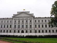
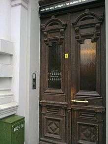
The Museum of Genocide Victims (Lithuanian: Genocido aukų muziejus) in Vilnius, Lithuania was established in 1992 by order of the Minister of Culture and Education and the President of the Lithuanian Union of Political Prisoners and Deportees. In 1997 it was transferred to the Genocide and Resistance Research Centre of Lithuania. The museum is located in the former KGB headquarters across from the Lukiškės Square, therefore it is informally referred to as the KGB Museum.[1]
The museum is dedicated to collecting and exhibiting documents relating to the 50-year occupation of Lithuania by the Soviet Union, the Lithuanian resistance, and the victims of the arrests, deportations, and executions that took place during this period.
The museum describes the human rights abuses of the Soviets as the “genocide”, while the actions of Nazis are described as “repression against Jewish and other populations of Lithuania.” The Genocide and Resistance Research Centre uses a broadened definition of the term "genocide" to include social groups, such as Lithuanian national intelligentsia deliberately targeted by the Soviets.[2]
History of the building

During the 19th century, Lithuania was part of the Russian Empire. The building, completed in 1890, originally housed the court of the Vilna Governorate. The German Empire used it during its World War I occupation of the country. After independence was declared, it served as a conscription center for the newly formed Lithuanian army and as the Vilnius commander's headquarters. During the Lithuanian Wars of Independence, the city was briefly taken by the Bolsheviks, and the building housed commissariats and a revolutionary tribunal. Following Żeligowski's Mutiny of 1920, Vilnius and its surroundings were incorporated into Poland, and the building housed the courts of justice for the Wilno Voivodship.
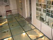
Lithuania was invaded by the Soviet Union in 1940, and following an ultimatum, became a Soviet Socialist Republic. Mass arrests and deportations followed, and the building's basement became a prison. In 1941 Nazi Germany invaded the country; the building then housed the Gestapo headquarters. Inscriptions on the cell walls from this era remain. The Soviets retook the country in 1944, and from then until independence was re-established in 1991, the building was used by the KGB, housing offices, a prison, and an interrogation center. Over 1,000 prisoners were executed in the basement between 1944 and the early 1960s, about one third for resisting the occupation.[3] Most bodies were buried in the Tuskulėnai Manor, which underwent reconstruction and is selected to host the second Museum of Genocide Victims.[4]
In addition to housing the museum, the building now serves as a courthouse and as the repository of the Lithuanian Special Archives.
Collections
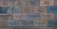
The non-violent aspect of the resistance is represented by various books, underground publications, documents, and photographs. The collection pertaining to the Forest Brothers' armed resistance includes documents and photographs of the partisans. A section devoted to the victims of deportations, arrests, and executions holds photographs, documents, and personal belongings; this collection is continually expanded by donations from the public, seeing the museum as the best means of preserving the materials.
Holocaust-related exposition
The first exposition mentioning the extermination of Jews in Lithuania during the World War II was opened in the museum in 2011. [5]
Footnotes
- ↑ "KGB Museum"
- ↑ Slate: Double Genocide - Lithuania wants to erase its ugly history of Nazi collaboration—by accusing Jewish partisans who fought the Germans of war crimes.
- ↑ "The former execution camera". The Museum of Genocide Victims. Retrieved 2009-01-22.
- ↑ Vitkauskaitė, Viktorija (2009-01-06). "Kiauros kišenės kliudo Genocido aukų muziejui". Lietuvos rytas (in Lithuanian). ISSN 1392-2351.
- ↑ "By adding of Holocaust exposition is attempted to resolve the "misunderstanding" (in Lithuanian)".
References
- Official website
- Official website - History of the building
- Official website - The former execution camera
- Official website - Collections
| Wikimedia Commons has media related to Museum of Genocide Victims. |
Coordinates: 54°41′17″N 25°16′16″E / 54.68806°N 25.27111°E