Victor Harbor, South Australia
| Victor Harbor South Australia | |
|---|---|
 City of Victor Harbor viewed from The Bluff | |
 Victor Harbor | |
| Coordinates | 35°33′0″S 138°37′0″E / 35.55000°S 138.61667°ECoordinates: 35°33′0″S 138°37′0″E / 35.55000°S 138.61667°E |
| Population | 10,380 (2006 census)[1] |
| Established | 1863 |
| Postcode(s) | 5211[2] |
| Location |
85 km (53 mi) South of Adelaide city centre via |
| LGA(s) | City of Victor Harbor |
| State electorate(s) | Finniss[3] |
| Federal Division(s) | Mayo[4] |
Victor Harbor is a town in South Australia on the south coast of the Fleurieu Peninsula, about 80 km south of the centre of Adelaide. The city is the largest population centre on the peninsula, with an economy based upon agriculture, fisheries and various industries. It is also a highly popular tourist destination, with the city's population greatly expanded during the summer holidays, usually by Adelaide locals looking to escape the summer heat.
It is a popular destination with South Australian high school graduates for their end of year celebrations, known colloquially as schoolies.
History

Traditionally home of the Ramindjeri clan of the Ngarrindjeri people, the bay on which Victor Harbor sits was discovered by Matthew Flinders in HMS Investigator in April 1802. As part of the first circumnavigation of the continent, Flinders was surveying the then unknown southern Australian coast from the west. He encountered Nicolas Baudin in Le Geographe near the Murray Mouth several kilometres to the east of the present day location of Victor Harbor. Baudin was surveying the coast from the east for Napoleonic France. Although their countries were at war, each captain was given documents by the other nation's government, stating that the ships were on scientific missions, and were therefore not to be regarded as ships of war. Together, the ships returned to the bay and sheltered, while the captains compared notes. Flinders named the bay Encounter Bay after the meeting.
In 1837 Captain Richard Crozier who was en route from Sydney to the Swan River Colony in command of the Cruizer-class HMS Victor,[5] anchored just off Granite Island and named the sheltered waters in the lee of the island 'Victor Harbor' after his ship.[6] About the same time two whaling stations were established, one at Rosetta Head (popularly known as "the Bluff") and the other near the point opposite Granite Island. Whale oil became South Australia’s first export. From 1839 the whaling station was managed for a time by Captain John Hart, a later Premier of South Australia. The town of Port Victor was laid out on the shores of Victor Harbor in 1863 when the horse-drawn tramway from Goolwa was extended to the harbour. The last whale was caught off Port Victor in 1872.
The town's name was changed to 'Victor Harbor' in 1921, as a result, it is said, of a near shipwreck blamed on confusion with Port Victoria in the Yorke Peninsula. Despite the fact that harbour is normally spelt with a "U" in modern Australian English, the name of the city is spelt Victor Harbor. This spelling, found in several geographical names in South Australia, including Outer Harbor, is the result of spelling errors made by an early Surveyor General of South Australia.[7][8] Conversely Victor Harbour railway station is spelt with the u.

At the start of the 20th Century, an attempt was made to make Port Victor, as it was then called, a main stop of mail-steamers.[9]
On the 26 December 1936, a one-off motor race meeting was held to the east of the town to commemorate the centenary of South Australia - the "South Australian Centenary Grand Prix".[10] The circuit was made of public roads, measured 12.6 kilometres in length and featured two long straights, two short straights, and several corners, including the banked Nangawooka Hairpin.[11] Winner of the 240 mile Grand Prix, which was held as a handicap, was Les Murphy in an MG P-type, from Tim Joshua in another P-type and Bob Lea-Wright in a Terraplane Special.[10]
Government
In 2006, the resident population of Victor Harbor was 10,380,[1] but over the summer holiday season the population almost trebles.[12] The ABS no longer publishes separate population estimates for Victor Harbor alone. At June 2015 the estimated urban population for Victor Harbor together with nearby Goolwa was 25,877.[13] Victor Harbor was declared a city in 2000. As a local government area, the City of Victor Harbor includes the surrounding rural area and the contiguous township of Encounter Bay as well as the town of Victor Harbor itself; its total area is 34,463 hectares. It shares boundaries with the District Council of Yankalilla and the Alexandrina Council. The city is in the state electoral district of Finniss and the federal Division of Mayo.
Attractions

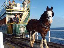
A popular site for visitors is Granite Island, which is connected to the mainland by a short tram/pedestrian causeway. The tram service is provided by the Victor Harbor Horse Drawn Tram, one of the very few horse-drawn tram routes remaining in public transit service. Granite island is home to a large colony of little penguins which are a popular attraction on the island. These penguins shelter on the island during the night, departing in the morning to hunt for fish before returning at sunset. Sadly this colony of penguins is now almost gone. At the last count in 2012, only seven were found. It is suspected that an increase in New Zealand fur seals in the area may be to blame. The Cockle Train heritage railway operated by SteamRanger runs steam locomotive and other antique train services between Victor Harbor and Goolwa stations. This route includes the oldest rail route in Australia, between Port Elliot and Goolwa.
During the months of June to September, whale spotting is a popular attraction. Southern right whales come to the nearby waters to calve and to mate. The South Australian Whale Centre located at Victor Harbor provides hands-on interactive activities and presentations as well as information and whale watching tips.[14] Greenhills Adventure Park offers activities including: waterslides, canoes, rock wall climbing, archery, mini golf, and go-karting. Victor Harbor is the centre of the surf zone known as the "South Coast" to Adelaide and local surfers. Popular surf beaches in the area include Parsons, Waitpinga, Middleton and Goolwa. The Granite Island breakwater usually shields the town from waves. Victor Harbor also offers numerous fishing opportunities varying from offshore reefs for larger boat based anglers to excellent surf fishing on the beaches closer to the Murray Mouth.
Festivals and events
This town hosts a three-day Schoolies Week festival in late November mainly for South Australian school leavers. Victor Harbor hosts the second largest Schoolies Week Festival in Australia after the Gold Coast. The centre of the town is a dry zone and hosts various live music and other events for participants. In addition to schoolies week another notable event is the Art Show run by the 'Lions' and exhibits of paintings are shown from all over Australia. The event is during the summer holidays in January and has grown to become the largest and one of the most prestigious displays of its kind,
References
- 1 2 Australian Bureau of Statistics (25 October 2007). "Victor Harbor (Urban Centre/Locality).". 2006 Census QuickStats.
- ↑ "Victor Harbor, South Australia". Postcodes Australia. Retrieved 2 August 2015.
- ↑ "District of Finniss Background Profile". ELECTORAL COMMISSION SA. Retrieved 2 August 2015.
- ↑ "Federal electoral division of Mayo, boundary gazetted 16 December 2011" (PDF). Australian Electoral Commission. Retrieved 2 August 2015.
- ↑ HMS Victor, 1814, Index of 19th Century Naval Vessels, www.pbenyon.plus.com/18-1900
- ↑ South Australian State Gazeteer
- ↑ "Why is Victor Harbor spelt without the 'u'?". Archived from the original on 2011-03-12.
- ↑ http://www.samemory.sa.gov.au/site/page.cfm?c=8786
- ↑ "LANDING THE ENGLISH MAILS AT PORT VICTOR.". Southern Argus (Port Elliot, SA : 1866 - 1954). Port Elliot, SA: National Library of Australia. 12 September 1901. p. 3. Retrieved 20 July 2013.
- 1 2 Walker, Terry (1995). Fast Tracks - Australia's Motor Racing Circuits: 1904-1995. Wahroonga, NSW: Turton & Armstrong. p. 170. ISBN 0908031556.
- ↑ Galpin, Darren. "Victor Harbor". GEL Motorsport Information Page. Retrieved 1 April 2016.
- ↑ Victor Harbor Urban Growth Management Strategy 2008–2030 prepared by Nolan Rumsby Planners
- ↑ "3218.0 – Regional Population Growth, Australia, 2014-15: Population Estimates by Significant Urban Area, 2005 to 2015". Australian Bureau of Statistics. Australian Bureau of Statistics. 30 March 2016. Retrieved 12 September 2016. Estimated resident population, 30 June 2015.
- ↑ South Australian Whale Centre Accessed 3 September 2012.
Further reading
- Charles R. Hodge, Guide-book to Victor Harbour (the miniature Naples of Australia) and the South Coast, Adelaide: The Advertiser, 1930, OCLC 37077169.
External links
| Wikimedia Commons has media related to Victor Harbor, South Australia. |
| Wikivoyage has a travel guide for Victor Harbor. |
| Topics | ||
|---|---|---|
| Regions | ||
| Cities and towns | ||
South Australia portal | ||