Verin Getashen
| Verin Getashen Վերին Գետաշեն | |
|---|---|
|
Verin Getashen seen in the background, as viewed from the hilltop cemetery in Lichk, September 2014 | |
 Verin Getashen Վերին Գետաշեն | |
| Coordinates: 40°07′58″N 45°14′55″E / 40.13278°N 45.24861°ECoordinates: 40°07′58″N 45°14′55″E / 40.13278°N 45.24861°E | |
| Country | Armenia |
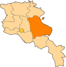
| Marz (Province) | Gegharkunik |
| Founded | 1828-29 |
| Area | |
| • Total | 2.66 km2 (1.03 sq mi) |
| Elevation | 1,976 m (6,483 ft) |
| Population (2010) | |
| • Total | 5,073 |
| • Density | 1,900/km2 (4,900/sq mi) |
| Time zone | GMT+4 (UTC+4) |
| Postal code | 1415 |

Verin Getashen (Armenian: Վերին Գետաշեն - meaning "Upper Getashen"; prior to 1945, Verin Adyaman - meaning "Upper Adyaman") is a major village in the Gegharkunik Province of Armenia, located just southwest of Lake Sevan. The village lies to the south of Nerkin Getashen (Lower Getashen) and was founded 1828-29 by migrants from Mush and Alashkert, in present-day Eastern Turkey. In the village are the churches of S. Astvatsatsin and S. Sargis.[1]
References
- Verin Getashen at GEOnet Names Server
- World Gazeteer: Armenia – World-Gazetteer.com
- Report of the results of the 2001 Armenian Census, National Statistical Service of the Republic of Armenia
- Brady Kiesling, Rediscovering Armenia, p. 45; original archived at Archive.org, and current version online on Armeniapedia.org.
This article is issued from Wikipedia - version of the 9/11/2016. The text is available under the Creative Commons Attribution/Share Alike but additional terms may apply for the media files.