Ventnor railway station
| Ventnor | |
|---|---|
|
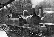
Ventnor railway station in 1963 | |
| Location | |
| Place | Ventnor |
| Area | Isle of Wight |
| Operations | |
| Pre-grouping | Isle of Wight Railway (1864 to 1923) |
| Post-grouping |
Southern Railway (1923 to 1948) Southern Region of British Railways (1948 to 1966) |
| Platforms | Two |
| History | |
| 10 September 1866[1] | Opened (Ventnor) |
| 1923 | Renamed (Ventnor Town) |
| 1953 | Renamed (Ventnor) |
| 17 April 1966 | Closed |
| Disused railway stations in the United Kingdom | |
|
Closed railway stations in Britain A B C D–F G H–J K–L M–O P–R S T–V W–Z | |
|
| |


Ventnor railway station was the terminus of the Isle of Wight Railway line from Ryde.
The station lay on a ledge 294 feet (90 m) above sea level which had to be quarried into the hill side. The station was immediately outside a 1,312 yards (1,200 m) long tunnel through St. Boniface Down. A lack of space meant that a turntable was used to allow steam engines to runaround their trains. In later years this was replaced by a three way switch. The various tracks merged just before the tunnel and the locomotives had to enter the tunnel during their runround manoeuvres.
The station had one side platform connected to the station buildings plus one narrow island platform. Unusually, there was only one track between the side platform and the island platform. When this track was already occupied by a train, a second incoming train had to arrive at the outer face of the island platform and a temporary bridge resembling a ship's gangway had to be manually pushed across the intervening track to permit passenger egress. Further away from the station buildings were goods sidings which mainly served coal merchants who operated from caves in the chalk sides of the station cutting.
The station closed to all traffic in April 1966, when the line south of Shanklin fell victim to the Beeching Axe. The track was lifted by 1970 and the station subsequently demolished. The site is now an industrial park with Southern Water using the tunnel to run water pipes through.
This station should not be confused with Ventnor West railway station.
| Preceding station | Disused railways | Following station | ||
|---|---|---|---|---|
| Terminus | British Rail Southern Region IoWR : Main line |
Wroxall | ||
See also
References
- ↑ Southern Region Record by R.H.Clark page 89
External links
Coordinates: 50°35′51″N 1°12′32″W / 50.5976°N 1.2088°W