Vendres
| Vendres | ||
|---|---|---|
|
The church of Vendres | ||
| ||
 Vendres | ||
|
Location within Occitanie region  Vendres | ||
| Coordinates: 43°16′14″N 3°13′30″E / 43.2706°N 3.225°ECoordinates: 43°16′14″N 3°13′30″E / 43.2706°N 3.225°E | ||
| Country | France | |
| Region | Occitanie | |
| Department | Hérault | |
| Arrondissement | Béziers | |
| Canton | Béziers-4 | |
| Intercommunality | Domitienne | |
| Government | ||
| • Mayor (2008–2014) | Jean-Pierre Perez | |
| Area1 | 37.8 km2 (14.6 sq mi) | |
| Population (2008)2 | 2,110 | |
| • Density | 56/km2 (140/sq mi) | |
| Time zone | CET (UTC+1) | |
| • Summer (DST) | CEST (UTC+2) | |
| INSEE/Postal code | 34329 / 34350 | |
| Elevation |
0–64 m (0–210 ft) (avg. 25 m or 82 ft) | |
|
1 French Land Register data, which excludes lakes, ponds, glaciers > 1 km² (0.386 sq mi or 247 acres) and river estuaries. 2 Population without double counting: residents of multiple communes (e.g., students and military personnel) only counted once. | ||

.svg.png)
Vendres is a commune in the Hérault department in the Occitanie region in southern France.
Population
| Historical population | ||
|---|---|---|
| Year | Pop. | ±% |
| 1962 | 805 | — |
| 1968 | 879 | +9.2% |
| 1975 | 781 | −11.1% |
| 1982 | 885 | +13.3% |
| 1990 | 1,230 | +39.0% |
| 1999 | 1,549 | +25.9% |
| 2008 | 2,110 | +36.2% |
Sights
The French Ministry of Culture lists three sites with protection as a monument historique.[1]
- The Château de Vendres, a 13th-century castle, has been protected as a monument historique since 1926. The remains include the curtain wall and a fortified gateway.[2]
- The so-called Temple of Venus is actually a Roman villa, protected as a monument historique since 1935.[3] The inhabitants of Vendres would like to think that the name of the village is derived from the goddess.[4] The villa seems to have been constructed in the first century AD on a site that dominates the present lagoon, though then the open sea. Excavated in the 17th century by Dominique de Bonsi, the site has since been interpreted in very different ways. The myth of a temple was an early 20th century idea, originated by Félix Mouret; Fernand Benoit suggested a salting works in 1965. Monique Clavel-Lévêque suggested in 1970 that the site was actually a rather luxurious villa and the latest excavations, by Ludovic Le Roy in 2008, confirm this view.[5] The site was built on a raised level to permit under floor heating. It underwent several alterations between the 1st and 5th centuries.[6]
- The remains of the so-called Roman aqueduct probably date more accurately to the 17th century. They have been protected as a monument historique since 1926.[7]
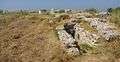 Roman villa
 "Roman" aqueduct
See also
References
- ↑ Ministry of Culture listing for Vendres, accessed 28 July 2013
- ↑ Ministry of Culture: Château, accessed 28 July 2013 (French)
Ministry of Culture photo - ↑ Ministry of Culture: Vestiges de la villa de Primuliac, accessed 28 July 2013 (French)
- ↑ "Visite du temple de Vénus", Midi Libre (Béziers edition), 22 July 2013, p. 2
- ↑ Information board in village centre
- ↑ Information board on site
- ↑ Ministry of Culture: Aqueduc dit aqueduc romain, accessed 28 July 2013 (French)
| Wikimedia Commons has media related to Vendres. |
This article is issued from Wikipedia - version of the 11/12/2016. The text is available under the Creative Commons Attribution/Share Alike but additional terms may apply for the media files.