Vastogirardi
| Vastogirardi | |
|---|---|
| Comune | |
| Comune di Vastogirardi | |
 Vastogirardi Location of Vastogirardi in Italy | |
| Coordinates: 41°46′N 14°16′E / 41.767°N 14.267°ECoordinates: 41°46′N 14°16′E / 41.767°N 14.267°E | |
| Country | Italy |
| Region | Molise |
| Province / Metropolitan city | Province of Isernia (IS) |
| Area | |
| • Total | 60.9 km2 (23.5 sq mi) |
| Elevation | 1,200 m (3,900 ft) |
| Population (Dec. 2004) | |
| • Total | 789 |
| • Density | 13/km2 (34/sq mi) |
| Time zone | CET (UTC+1) |
| • Summer (DST) | CEST (UTC+2) |
| Postal code | 86089 |
| Dialing code | 0865 |
| Website | Official website |
Vastogirardi is a comune (municipality) in the Province of Isernia in the Italian region Molise, located about 40 kilometres (25 mi) northwest of Campobasso and about 20 kilometres (12 mi) north of Isernia. As of 31 December 2004, it had a population of 789 and an area of 60.9 square kilometres (23.5 sq mi).[1]
Vastogirardi borders the following municipalities: Agnone, Capracotta, Carovilli, Castel di Sangro, Forlì del Sannio, Rionero Sannitico, Roccasicura, San Pietro Avellana.
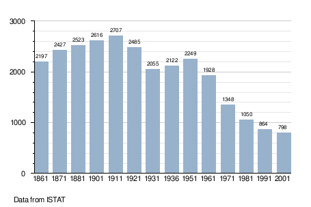
Demographic evolution
References
External links
This article is issued from Wikipedia - version of the 1/31/2015. The text is available under the Creative Commons Attribution/Share Alike but additional terms may apply for the media files.