Varatella
| Varatella | |
|---|---|
 | |
| Country | Italy |
| Basin | |
| Main source |
Ligurian Alps 170 m (560 ft) |
| River mouth |
Ligurian Sea in Borghetto Santo Spirito (SV, Italy) 0 m (0 ft) 44°06′43.2″N 8°14′45.6″E / 44.112000°N 8.246000°ECoordinates: 44°06′43.2″N 8°14′45.6″E / 44.112000°N 8.246000°E |
| Basin size | 44 km2 (17 sq mi)[1] |
| Physical characteristics | |
| Length | 7 km (4.3 mi)[1] |
The Varatella (or Varatello[2]) is a 7-kilometre (4.3 mi) stream of Liguria (Italy).
Geography
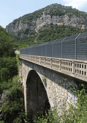
A bridge on the Varatella
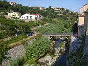
The Varatella in Toirano
The river is formed at 170 m by the confluence of two streams, Rio della Valle and Rio di Carpe, in the comune of Toirano. The river then flows through the Valle Varatella and crosses the centre of Torirano, where it receives from right the waters of rio Barescione, its main tributary. Heading south-east the Varatella reaches Borghetto Santo Spirito and ends its course in the Ligurian Sea, after being crossed by Autostrada A10, Genoa–Ventimiglia railway and Aurelia national road.
Varatella basin (44 km2) is totally included in the Province of Savona.[3]
Main tributaries

Rio Barescione
- Left hand:
- rio della valle;
- rio delle Banchette.
- Right hand:
- rio di Carpe;
- rio Barescione;
- rio di Riva.
References
- 1 2 (Italian)PIANO DI BACINO STRALCIO SUL RISCHIO IDROGEOLOGICO, Provincia di Savona, on-line in pdf: (access: 2015-10-09)
- ↑ Carta turistica ed escursionistica - Provincia di Savona - 1:50.000 map of Provincia di Savona
- ↑ 1:25.000 map of the Istituto Geografico Militare, on-line on www.pcn.minambiente.it/viewer
External links
![]() Media related to Varatella at Wikimedia Commons
Media related to Varatella at Wikimedia Commons
- (Italian) Torrente Varatella www.fiumi.com (fishing rules for the stream)
This article is issued from Wikipedia - version of the 6/19/2016. The text is available under the Creative Commons Attribution/Share Alike but additional terms may apply for the media files.