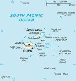
Vanua Levu
 Map of Vanua Levu | |
 | |
| Geography | |
|---|---|
| Location | Pacific Ocean |
| Coordinates | 16°35′S 179°11′E / 16.583°S 179.183°E |
| Archipelago | Vanua Levu Group |
| Area | 5,587.1 km2 (2,157.2 sq mi) |
| Length | 180 km (112 mi) |
| Width | 50 km (31 mi) |
| Highest elevation | 1,111 m (3,645 ft) |
| Highest point | Mount Batini |
| Administration | |
|
Fiji | |
| Division | Northern Division |
| Largest settlement | Labasa (pop. 27,949) |
| Demographics | |
| Population | 135,961 (2007) |
| Pop. density | 23.27 /km2 (60.27 /sq mi) |
| Ethnic groups | Mainly Native Fijians and Fiji Indians |
Vanua Levu (pronounced [βaˈnua ˈleβu]), formerly known as Sandalwood Island, is the second largest island of Fiji. Located 64 kilometres (40 miles) to the north of the larger Viti Levu, the island has an area of 5,587.1 km² and a population of 135,961 as of 2007.
Geography
Geologists interpret the shape of Vanua Levu as an amalgamation of several islands that melded through successive stages of uplift. The main part of the island is roughly shaped like a tall, thin triangle 30 to 50 kilometres (19–31 miles) in width and 180 kilometres (110 miles) in length, rotated so that the point is to the northeast. This point, the northernmost in the Fiji chain, is Udu Point. From the southeastern side of this triangle, a long peninsula stretches out into the Koro Sea. The island is surrounded by coral reefs, and is rough and hilly. The antimeridian passes through this island.
A rugged mountain range divides the island horizontally, forming much of the boundary between the Provinces of Cakaudrove and Macuata. The highest peaks are Mount Batini, also known as Nasorolevu, with an altitude of 1,111 metres (3,645 feet), and, 16 kilometres (9.9 miles) further north-east, Dikeva, also known as Mount Thurston, with an altitude of 1,030 metres (3,380 feet). Vanua Levu's main mountain ranges lie near the windward, southern coasts, making them much wetter. Northern Vanua Levu, by contrast, has a dry climate eight months of the year, enabling sugar cane, the island's major crop, to thrive there. Vanua Levu has a number of rivers, including the Labasa, the Wailevu, and the Qawa. These three form a delta on which the town of Labasa stands. None of the island's rivers are navigable by large vessels. There are also many well known rivers on Vanua levu. The first is the most dangerous river, the Wainikoro river, known for its shark attacks. The second is the Dreketi river, the deepest river in Fiji.
Demographics and economic activities
.jpg)
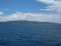
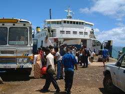
The island's main population centres are the towns of Labasa, in the north, and Savusavu, located at the foot of the peninsula. Labasa, with a population of almost 25,000 at the 1996 census, has a large Indian community, and is a major centre of Fiji's sugar industry. Savusavu is smaller, with a population of just under 5000, but is a popular centre for tourists owing to its diving and yachting facilities. The main industry on the island is sugar cane production, especially in the north. Copra is also an important crop. Tourism is now becoming a major industry on Vanua Levu also.
Politics
For administrative purposes, Vanua Levu is divided into three Provinces: Bua (in the west), Macuata (in the north-east), and Cakaudrove (in the south-east). These three provinces also comprise the Northern Division of Fiji. Together with the remote Lau Islands, Vanua Levu and its outliers form the Tovata Confederacy, one of three traditional alliances of Fiji's chiefs. The Paramount Chief, who is based on the nearby island of Taveuni, holds the title of Tui Cakau. Only two population centres - Labasa and Savusavu - have been incorporated as Towns. Each is governed by a Mayor and a Town Council, whose members are elected for a three-year term and choose the Mayor from among themselves. At present, normative local body governance is in abeyance, and all cities and towns in Fiji are being run temporarily by Special Administrators appointed by the central government.
History
_-_Copy.jpg)
Vanau Levu was settled about 3,100 ago, with the settlers living in houses raised above the reefs on the shores. Between 1250 and 1350 the Pacific sea level fell 30 cm, exposing the tops of the reefs. This killed the abundant sea food, it also dropped the ground water table below the depth of the roots of the crops. The scarcity of food caused conflict and war. In response, the people moved from seaside villages, for mountaintop fortified villages. This forts were occupied until about 1870, with the last clear indication of warfare about 1860.[2]
The Dutch navigator Abel Tasman was the first known European to sight Vanua Levu, in 1643. He was followed by Captain William Bligh in 1789, en route to Timor while escaping from the Mutiny on the Bounty, in which his crew had forced him and those loyal to him off deck and cast them adrift in a lifeboat. Captain James Wilson subsequently explored the area in 1797 in his ship Duff.
Traders began exploiting sandalwood thickets in the Bua Bay area around 1805, which had been discovered by shipwrecked sailors of the schooner Argo.[3] By 1815, however, the supply had been depleted and apart from the occasional visit from whalers and bêche-de-mer traders, the island received little further attention until 1840, when a young sailor known as Jackson deserted his crew at Somosomo on the nearby island of Taveuni, was adopted by a local Chief, and explored much of eastern and northern Vanua Levu.
Settlers from Australia and New Zealand established coconut plantations in the Savusavu area in the 1860s. Intermarriage with Fijian people produced a mixed-race elite, which also prospered from the sale of copra, of which Savusavu was a major centre, until the Great Depression of the 1930s led to a collapse in the price of copra. In the same period, Indians founded the town of Labasa, now a major sugar-producing centre.
In 2012, the nation of Kiribati began negotiating to buy 5,000 acres (2,023 hectares) of the island to house its population, which is expected to need to move as their islands are inundated by rising sea levels.[4]
References
- 1 2 "Wesleyan Chapel, Naivuki, Vanua-Levu, Feejee". The Wesleyan Juvenile Offering: A Miscellany of Missionary Information for Young Persons. Wesleyan Missionary Society. X: 67–97. September 1853. Retrieved 29 February 2016.
- ↑ Patrick Nunn (June 21, 2016). "Fiji's experience with sea-level rise 600 years ago shows how climate change can inspire violence.". Slate.com. Retrieved August 11, 2016.
- ↑ Dodge, Earnest S. (1976). Islands and Empires: Western Impact on the Pacific and East Asia. Minneapolis: University of Minnesota Press,. pp. 62–63. ISBN 978-0-8166-0853-9.
- ↑ Paul Chapman (2012-03-07). "Entire nation of Kiribati to be relocated over rising sea level threat". The Daily Telegraph. Retrieved 2012-03-08.
External links
![]() Vanua Levu travel guide from Wikivoyage
Coordinates: 16°35′S 179°11′E / 16.583°S 179.183°E
Vanua Levu travel guide from Wikivoyage
Coordinates: 16°35′S 179°11′E / 16.583°S 179.183°E