Valtournenche
| Valtournenche | ||
|---|---|---|
| Comune | ||
| Comune di Valtournenche Commune de Valtournenche | ||
| ||
 Valtournenche Location of Valtournenche in Italy | ||
| Coordinates: IT 45°53′N 07°37′E / 45.883°N 7.617°ECoordinates: IT 45°53′N 07°37′E / 45.883°N 7.617°E | ||
| Country | Italy | |
| Region | Aosta Valley | |
| Province / Metropolitan city | Aosta | |
| Frazioni | Barmasse, Bioley, Brengaz, Breuil-Cervinia, Busserailles, Chaloz, Châtelard, Champ l'éve, Cheneil, Cheperon, Tsignanaz (Cignana), Clou, Cré, Cré-du-Pont, Crépin, Crétaz, Duerche, Euillaz, Fontaine, La Muranche, La Vénaz, Layet, Laviel, Le Lou (Loz), Losanche, Maën, Maisonnasse, Montaz, Moulin, Mont-Mené, Mont-Perron, Pâquier (chef-lieu), Pecou, Les Perrères, Pessey, Promindoz, Saix, Servaz, Singlin, Tourtourouse, Ussin, Valmartin | |
| Area | ||
| • Total | 115 km2 (44 sq mi) | |
| Elevation | 1,528 m (5,013 ft) | |
| Population (December 31, 2004) | ||
| • Total | 2,163 | |
| • Density | 19/km2 (49/sq mi) | |
| Demonym(s) | Valtournains | |
| Time zone | CET (UTC+1) | |
| • Summer (DST) | CEST (UTC+2) | |
| Postal code | 11028 | |
| Dialing code | 0166 | |
| Website | http://www.comune.valtournenche.ao.it | |
.svg.png)
Valtournenche is a town and comune in the Aosta Valley region of north-western Italy. It is named after and covers most of the Valtournenche, a valley on the left side of the Dora Baltea, from Châtillon to the Matterhorn.
Notable people
- Jean-Antoine Carrel (1829–1890), mountain climber
- Jean-Joseph Maquignaz (1829–1890), mountain climber
- Georges Carrel (1800–1870), canon, mountain climber and botanist
- Luigi Carrel (1901–1983), mountain climber
- Piero Maquignaz, skier and mountain climber
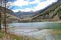 The Maën lake
This article is issued from Wikipedia - version of the 9/22/2016. The text is available under the Creative Commons Attribution/Share Alike but additional terms may apply for the media files.