Terra nullius
Terra nullius (/ˈtɛrə.nʌˈlaɪəs/, plural terrae nullius) is a Latin expression deriving from Roman law meaning "nobody's land",[1] which is used in international law to describe territory which has never been subject to the sovereignty of any state, or over which any prior sovereign has expressly or implicitly relinquished sovereignty. Sovereignty over territory which is terra nullius may be acquired through occupation,[2] (see reception statute) though in some cases doing so would violate an international law or treaty.
Australia
Indigenous Australians had inhabited Australia for over 50,000 years before European settlement, which commenced in 1788. Indigenous customs, rituals and laws were unwritten and their social and political organization was unknown or understood by Europeans as being analogous to their own institutions, and the British could not find recognised leaders with whom they could sign treaties.
The first test of terra nullius in Australia occurred with the decision of R v Tommy (Monitor, 29 November 1827), which indicated that the native inhabitants were only subject to English law where the incident concerned both natives and settlers. The rationale was that Aboriginal tribal groups already operated under their own legal systems. This position was further reinforced by the decisions of R v Boatman or Jackass and Bulleyes (Sydney Gazette, 25 February 1832) and R v Ballard (Sydney Gazette, 23 April 1829).
Prompted by Batman's Treaty (June 1835) with Wurundjeri elders of the area around the future Melbourne, in August 1835, Governor Bourke of New South Wales indicated the significance of the doctrine of terra nullius by a Proclamation that Batman's so-called treaty was null and void because Indigenous Australians could not sell or assign land, nor could an individual person or group acquire it, other than through distribution by the Crown.[3]
The first decision of the New South Wales Supreme Court to make explicit use of the term terra nullius was R v Murrell and Bummaree (unreported, New South Wales Supreme Court, 11 April 1836, Burton J). Terra nullius was not endorsed by the Judicial Committee of the Privy Council until the decision of Cooper v Stuart in 1889, some fifty-three years later.[4]
In 1971, in the controversial case of Milirrpum v Nabalco Pty Ltd, popularly known as the Gove land rights case, Justice Richard Blackburn ruled that Australia had been considered "desert and uncultivated" (a term which included territory in which resided "uncivilized inhabitants in a primitive state of society") before European settlement, and therefore, by the law that applied at the time, open to be claimed by right of occupancy, and that there was no such thing as native title in Australian law. The concept of terra nullius was not considered in this case, however.[5] Court cases in 1977, 1979, and 1982 – brought by or on behalf of Aboriginal activists – challenged Australian sovereignty on the grounds that terra nullius had been improperly applied, therefore Aboriginal sovereignty should still be regarded as being intact. The courts rejected these cases, but the Australian High Court left the door open for a reassessment of whether the continent should be considered "settled" or "conquered". Later, on 1 February 2014, the traditional owners of land on Badu Island received freehold title to 10,000 hectare in an act of the Queensland Government.[6]
In 1982, Eddie Mabo and four other Torres Strait Islanders from Mer (Murray Island) started legal proceedings to establish their traditional land ownership. This led to Mabo v Queensland (No 1). In 1992, after ten years of hearings before the Queensland Supreme Court and the High Court of Australia, the latter court found that the Mer people had owned their land prior to annexation by Queensland.[7] The ruling thus had far-reaching significance for the land claims of both Torres Strait Islanders and other Indigenous Australians.
The controversy over Australian land ownership has erupted into the so-called "History wars." Historian Michael Connor, in his critique of the legal fiction, has claimed that the concept of terra nullius was a straw man developed in the late 20th century:
By the time of Mabo in 1992, terra nullius was the only explanation for the British settlement of Australia. Historians, more interested in politics than archives, misled the legal profession into believing that a phrase no one had heard of a few years before was the very basis of our statehood, and Reynolds' version of our history, especially The Law of the Land, underpinned the Mabo judges' decision-making.[8]
There is some controversy as to the meaning of the term. For example, it is asserted that, rather than implying mere emptiness, terra nullius can be interpreted as an absence of civilized society. English common law of the 18th century allowed for the legal settlement of "uninhabited or barbarous country".[9]
Other claims of terra nullius
Svalbard
Svalbard was considered a terra nullius until the Svalbard Treaty of 9 February 1920 recognised Norwegian sovereignty over the islands. Scotland or United Kingdom, the Netherlands, and Denmark–Norway all claimed sovereignty over the region in the seventeenth century, but none permanently occupied the islands. Expeditions from each of these polities visited Svalbard principally during the summer for whaling, with the first two sending a few wintering parties in the 1620s and 1630s.
Greenland
Norway occupied and claimed parts of (then uninhabited) Eastern Greenland in the 1920s, claiming that it constituted terra nullius The matter was decided by the Permanent Court of International Justice against Norway. The Norwegians accepted the ruling and withdrew their claim.
Antarctica
Another example of a terra nullius was Antarctica. Several countries made claims to parts of the continent in the first half of the 20th century, while other areas remain unclaimed.
Scarborough Shoal
The Philippines and the People's Republic of China both claim the Scarborough Shoal or Panatag Shoal or Huangyan Island (黄岩岛), nearest to the island of Luzon, located in the South China Sea. The Philippines claims it under the principles of terra nullius and EEZ (Exclusive Economic Zone). China's claim refers to its discovery in the 13th century by Chinese fishermen. The former Nationalist government on the Chinese mainland had also claimed this territory after the founding of the Republic of China in 1911. However, the 2016 Hague ruling named the Philippines as the rightful owner of the islands. Despite this, China continues to build artificial islands in the South China Sea and Scarborough Shoal is a prime location for another one. Chinese ships have been seen in the vicinity of the shoal. Observers of the photos have concluded that the ships lack dredging equipment and therefore represent no imminent threat of reclamation work.[10]
New Zealand
In 1840, Lieutenant William Hobson, following instructions of the British government, pronounced the southern island of New Zealand to be uninhabited by civilized peoples, which qualified the land to be terra nullius, and therefore fit for the Crown's political occupation. Hobson's decision was also influenced by a small party of French settlers heading towards Akaroa on Banks Peninsula to settle in 1840.
Canada
Joseph Trutch, the first Lieutenant Governor of British Columbia, insisted that First Nations had never owned land, and thus could safely be ignored. It is for this reason that most of British Columbia remains unceded land.[11]
In Guerin v. The Queen, a Supreme Court of Canada decision on aboriginal rights, the Court stated that the government has a fiduciary duty toward the First Nations of Canada and established aboriginal title to be a sui generis right. Since, there has been a more complicated debate and a general narrowing of the definition of "fiduciary duty".
Guano Islands
The Guano Islands Act of 18 August 1856 enabled citizens of the U.S. to take possession of islands containing guano deposits. The islands can be located anywhere, so long as they are not occupied and not within the jurisdiction of other governments. It also empowers the President of the United States to use the military to protect such interests, and establishes the criminal jurisdiction of the United States.
Pinnacle Islands (Senkaku/Diaoyu)
A disputed archipelago in the East China Sea, the uninhabited Senkaku Islands, are claimed by Japan to have become part of its territory as terra nullius in January 1895, following the First Sino-Japanese War. However, this interpretation is not accepted by the People's Republic of China (PRC) and the Republic of China (Taiwan), both of whom claim sovereignty over the islands.
Burkina Faso and Niger
A narrow strip of land adjacent to two territorial markers along the Burkina Faso–Niger border was claimed by neither country until the International Court of Justice settled a more extensive territorial dispute in 2013. The former terra nullius was awarded to Niger.[12]
Clipperton Island
The sovereignty of Clipperton Island was settled by arbitration between France and Mexico. King Victor Emmanuel III of Italy rendered a decision in 1931 that " 'the sovereignty of Clipperton Island belongs to France from the date of November 17, 1858.' The Mexican claim was rejected for lack of proof of prior Spanish discovery and, in any event, no effective occupation by Mexico before 1858, when the island was therefore territorium nullius, and the French occupation then was sufficient and legally continuing."[13]
Sealand
One of the few micronations to control any actual territory, the Principality of Sealand has existed de facto since 1967 on an abandoned British anti-aircraft gun tower in the North Sea. At the point when it was taken over, the tower had been abandoned by the Royal Navy and was outside British territorial waters. Paddy Roy Bates, who styled himself Prince, claimed that it was terra nullius. Despite rejecting this claim on the basis that the tower is an artificial structure, the British government has never attempted to evict the Sealanders, and a court in 1968 confirmed that at that point, the tower was outside British jurisdiction.[14]
Current terrae nullius

Bir Tawil
Between Egypt and Sudan is the 2,060 km2 (795 sq mi) landlocked territory of Bir Tawil, which was created by a discrepancy between borders drawn in 1899 and 1902. One border placed Bir Tawil under Sudan's control and the Hala'ib Triangle under Egypt's; the other border did the reverse. Both countries assert the border that lets them claim Hala'ib, which is significantly larger and next to the Red Sea, with the side effect that Bir Tawil is unclaimed by either nation. The area is, however, under the de facto control of Egypt, although it is not shown on official Egyptian maps.[15] Bir Tawil has no settled population.
In June 2014, Jeremiah Heaton planted a flag in Bir Tawil to claim the region as a new sovereign state, the Kingdom of North Sudan,[16][17][18][19] and subsequently announced the establishment of self-styled "embassies" elsewhere in the world;[20] no governmental entity has recognized this claim.
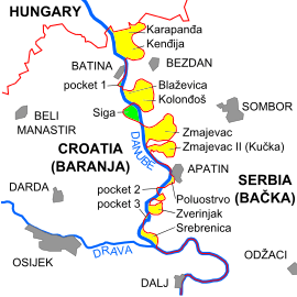
Land portions along the Danube river
As a consequence of the border dispute between Croatia and Serbia, there are some areas along the western bank of the Danube river that are unclaimed by either country. Serbia has de facto control over areas where territorial claims of both nations overlap, while Croatia has control over the mutually unclaimed parts.[21]
In 2015, Czech activist Vít Jedlička unilaterally declared a micronation he named Free Republic of Liberland, espousing libertarian ideals and claiming the largest of the disputed pockets on the right (western) bank of the Danube.[22][23][24] Shortly after, the Kingdom of Enclava was declared,[25] eventually claiming the second largest pocket as their territory,[26] followed by the Principality of Ongal, which claimed the remaining pockets.[27]
The Croatian Ministry of Foreign and European Affairs has rejected these claims, stating that the differing border claims between Serbia and Croatia do not involve terra nullius, and are not subject to occupation by a third party,[28] and the Serbian Ministry of Foreign Affairs has stated that Liberland does not infringe upon the border of Serbia.[29]
Land strip at the Croatia–Slovenia border
Brezovica pri Metliki is a village located in the southeastern part of Slovenia, about 50 km air distance from Zagreb, Croatia. Brezovica Žumberačka is a Croatian exclave that is surrounded by the Slovenian village. It is confirmed by both Croatian and Slovenian cadaster maps, although boundary lines slightly differ.[30][31][32] Croatia has a second exclave within 400 meters of Brezovica Žumberačka. This exclave would normally be an enclave also, except that neither Slovenia nor Croatia claims one parcel of land that adjoins the exclave.[32] If Slovenia were to claim the parcel, Croatia's exclave would become an enclave as well. As it is, the exclave is bordered by Slovenia and terra nullius.
In April 2015, a group of tourists from Poland visited Brezovica to declare unclaimed land strip as sovereign state, the Kingdom of Enclava.[33][34][35][36][37] On 21 May 2015, the Slovenian Foreign Ministry said that the territory was Slovenian and that the determination of land borders between Slovenia and Croatia should take place in the court of arbitration.[38] The founders of Enclava ceased their claim and moved to the second of the largest unclaimed land portions along the Danube river near the Croatian village of Batina and Liberland.,[39] although the confederation of Autia claimed it first.
Dixon Entrance
The United States and Canada define the maritime boundary through this area in different ways. The boundary was originally agreed upon in 1825 between Russia and the UK, but the treaty wording was insufficiently precise. To resolve the ambiguity, an arbitration tribunal in 1903 issued a decision defining the Alaska/Canada boundary, which included marking a straight line from Cape Muzon to the entrance of Portland Canal, known as the "A–B" line.[40][41] The court specified the initial boundary point (Point "A") at the northern end of Dixon Entrance[42] and also designated Point "B" 72 NM to the east.[43] Canada's position is that "A" and "B" are part of the arbitrated boundary delimitation, thus rendering nearly all of Dixon Entrance as internal waters. The U.S. does not recognize the "A–B" line as an official boundary, instead regarding it as allocating sovereignty over the land masses within the Dixon Entrance,[40] with Canada's land south of the line. The U.S. regards the waters as subject to international marine law, and in 1977 it defined an equidistant territorial line that is mainly to the south of the "A–B" line, but not entirely. North of Dundas Island, the equidistance line swings north of the "A–B" line.[40] The intersecting lines create four separate water areas with differing claim status. The two areas south of the "A–B" line are claimed by both countries. The other two water areas are north of the "A–B" line and are not claimed by either country. The two unclaimed areas are about 72 km2 and 1.4 km2 in size.[40]
Unclaimed areas in Antarctica
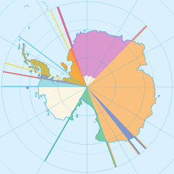
While several countries have made claims to parts of Antarctica, most of Marie Byrd Land (the portion east of 150°W) has not been claimed by any sovereign nation. Signatories to the Antarctic Treaty of 1959 agreed not to make such claims, except the Soviet Union and the United States, who reserved the right to make a claim.
The Norwegian claim to Queen Maud Land left its southern boundary undefined,[44] so the southern part of that segment of Antarctica may also have been unclaimed until Norway resolved that ambuguity on 12 June 2015 when it formally annexed that area.[45]
International sea
Under the United Nations Convention on the Law of the Sea of 1982, the international waters and international seabed are treated under the common heritage of mankind principle by the signatories of the convention.
Celestial bodies
According to the Outer Space Treaty of 1967, outer space, including the Moon and other celestial bodies, is not subject to national appropriation by claim of sovereignty, by means of use or occupation, or by any other means that fits. For the signatories of the treaty, celestial bodies are treated, de jure, under the common heritage of mankind principle.[46]
However, this has not stopped many people from exploiting the fact that these claims only account for countries, not companies and individuals. No known micronations, however, have been claimed on other celestial bodies, such as the moon, with the exception of the Aerican Empire.
Limits of national jurisdiction and sovereignty
The principal treaties defining sovereignty beyond land territory are the Outer Space Treaty and the United Nations Convention on the Law of the Sea. They confirm the full national jurisdiction over the coastal waters (internal and territorial) and over the continental shelf underground. There are limitations that allow foreign vessels the right of passage and for foreign states to lay pipelines and cables in the territorial waters, exclusive economic zone and continental shelf surface. Exploitation of marine life and mineral resources in these areas is a reserved right of the coastal state. Exploitation of mineral resources in the extended continental shelf is a reserved right of the coastal state, but it must pay tax on these activities to the International Seabed Authority (UNCLOS, Art. 82). The archipelagic waters are covered by a special hybrid regime with rules regarding territorial and internal waters.
On vessels, spacecraft and structures in places with international jurisdiction or terra nullius, the general rule is that the operator state of the vessel is responsible for it and regulates laws there. Additionally, the crew are subject to the laws of the state of their citizenship . Earth orbital slots are the only type of extraterrestrial real estate recognised by law and are allocated by the International Telecommunication Union (part of the UN System).
There are some undefined limits for the application of jurisdiction and sovereignty:
- The boundary between outer space and airspace is not defined. In common parlance, the Kármán line (100 km) is generally recognized as the boundary between airspace and outer space, but this definition is not explicitly recognized in any treaty.
- UNCLOS commission is defining the limits of the extended continental shelf.
- UNCLOS is inconclusive about the status of airspace over the contiguous zone (whether it is treated as international airspace or some special rules apply there).
- There is no defined bottom underground limit for jurisdiction and sovereignty, because in practice there are no cases where it is relevant and the current technology level does not allow the reaching of depths where conflicting claims could be made (there are some disputes about border underground oil and gas reserve reservoirs, but their depth is not enough so that the curvature of the Earth and the exact line of the underground border between the states matters).
The current entities that exercise jurisdiction and sovereignty rights are:
- the 193 United Nations member states;
- Holy See and Palestine, the United Nations observer states;
- Cook Islands and Niue, associated with and represented in foreign affairs by New Zealand;
- the 17 non-self-governing territories with recognised right for self-determination by the United Nations (currently under jurisdiction of 5 UN members);
- the 10 states with limited recognition;
| Outer space (including Earth orbits; the Moon and other celestial bodies, and their orbits) | |||||||
| national airspace | territorial waters airspace | contiguous zone airspace | international airspace | ||||
| land territory surface | internal waters surface | territorial waters surface | contiguous zone surface | Exclusive Economic Zone surface | international waters surface | ||
| internal waters | territorial waters | Exclusive Economic Zone | international waters | ||||
| land territory underground | Continental Shelf surface | extended continental shelf surface | international seabed surface | ||||
| Continental Shelf underground | extended continental shelf underground | international seabed underground | |||||
See also
- Aboriginal land claims
- Australia
- Land claim
- Manifest destiny
- No man's land
- Neutral territory
- Res nullius (original and broader formulation in law)
- Uncontacted people
- Uti possidetis
References
- Notes
- ↑ "Definition of terra nullius- English Dictionary". Allwords.com. Retrieved 15 June 2010.
- ↑ "New Jersey v. New York, 523 US 767 (1998)". US Supreme Court. 26 May 1998. Retrieved 29 January 2010.
Even as to terra nullius, like a volcanic island or territory abandoned by its former sovereign, a claimant by right as against all others has more to do than planting a flag or rearing a monument. From the 19th century the most generous settled view has been that discovery accompanied by symbolic acts give no more than "an inchoate title, an option, as against other states, to consolidate the first steps by proceeding to effective occupation within a reasonable time.8 I. Brownlie, Principles of Public International Law 146 (4th ed.1990); see also 1 C. Hyde, International Law 329 (rev.2d ed.1945); 1 L. Oppenheim International Law §§222-223, pp. 439–441 (H. Lauterpacht 5th ed.1937); Hall A Treatise on International Law, at 102–103; 1 J. Moore, International Law 258 (1906); R. Phillimore, International Law 273 (2d ed. 1871); E. Vattel, Law of Nations, §208, p. 99 (J. Chitty 6th Am. ed. 1844).
- ↑ "Governor Bourke's Proclamation 1835 (UK)". Documenting a Democracy: 110 key documents that are the foundation of our nation. National Archives of Australia. Retrieved 2008-03-05.
This document implemented the doctrine of terra nullius upon which British settlement was based, reinforcing the notion that the land belonged to no nation prior the British Crown taking possession of it. Aboriginal people therefore could not sell or assign the land, nor could an individual person acquire it, other than through distribution by the Crown... Although many people at the time also recognised that the Aboriginal occupants had rights in the lands (and this was confirmed in a House of Commons report on Aboriginal relations in 1837), the law followed and almost always applied the principles expressed in Bourke's proclamation. This would not change until the Australian High Court's decision in the Mabo Case in 1992.
- ↑ Decisions of the Superior Courts of New South Wales, 1788–1899, published by the Division of Law, Macquarie University
- ↑ Milirrpum v Nabalco Pty Ltd, (1971) 17 FLR 141
- ↑ Torres News, 10–16 February 2014
- ↑ "Indigenous people still battle for land rights: activist". ABC News Online. Australian Broadcasting Corporation. 3 June 2007. Retrieved 3 July 2011.
- ↑ Michael Connor in The Bulletin (Sydney), 20 August 2003: (see further Connor 2005.)
- ↑ "Australasian Legal Information Institute". AustLII. Retrieved 2010-06-08.
- ↑ Mollman, Steve. "The "strategic triangle" that would allow Beijing to control the South China Sea". Quartz. Retrieved 2016-10-27.
- ↑ "A Short Commentary on Land Claims in BC". Union of British Columbia Indian Chiefs. Retrieved 2010-06-08.
- ↑ http://www.icj-cij.org/docket/files/149/17306.pdf page 28, between Tong-Tong & Tao astronomical markers
- ↑ Ireland, Gordon (1941). Boundaries, possessions, and conflicts in Central and North America and the Caribbean. New York: Octagon Books. p. 320.
- ↑ Regina v. Paddy Roy Bates and Michael Roy Bates, The Shire Hall, Chelmsford, 25 October 1968. "Regina v. Paddy Roy Bates and Michael Roy Bates". The Shire Hall, Chelmsford. Archived from the original on 2 March 2007. Retrieved 29 May 2015.
- ↑ Central Intelligence Agency. CIA World Factbook 2009 MobileReference, 2009. ISBN 1607783339
- ↑ Gibson, Allie Robinson (10 July 2014). "Abingdon man claims African land to make good on promise to daughter". Bristol Herald Courier. Bristol, Virginia: Berkshire Hathaway. Retrieved 2015-04-23.
- ↑ Najarro, Ileana (12 July 2014). "Va. man plants flag, claims African country, calling it 'Kingdom of North Sudan'". Washington Post. Washington, DC. Retrieved 2015-04-23.
- ↑ Ensor, Josie (14 July 2014). "US father takes unclaimed African kingdom so his daughter can be a princess". The Daily Telegraph. London. Retrieved 27 July 2014.
- ↑ "Mapping micronations". Al Jazeera. 14 August 2014. Retrieved 2015-04-23.
Passports, currencies and flags: We discuss what it takes to create your own country.
- ↑ "Embassies – Kingdom of North Sudan". Retrieved 15 April 2015.
- ↑ "On Virtual Narratives at Croatia's Borders". Croatian Ministry of Foreign and European Affairs. 17 July 2015.
- ↑ "Welcome to Liberland, the tiny patch of woodland claiming to be the world's newest country". The Telegraph. 30 April 2015.
- ↑ "Czech proclaims new sovereign state between Serbia and Croatia: Liberland". InSerbia. 15 April 2015.
- ↑ "Welcome to Liberland, Europe's newest (micro) state". EUobserver. 4 May 2015.
- ↑ "Polish tourists proclaim 'Kingdom of Enclava'". Agence France-Presse. 15 May 2015. Archived from the original on May 18, 2015.
- ↑ "About Enclava". Enclava.
- ↑ "Екокняжество Онгъл… като истинска държава". Eurochicago (in Bulgarian). 16 June 2015.
- ↑ "On Virtual Narratives at Croatia's Borders". Hungarian Embassy of the Republic of Croatia. Ministry of Foreign and European Affairs of the Republic of Croatia. Retrieved 6 August 2015.
- ↑ McKirdy, Euan (25 April 2015). "Liberland: Could the world's newest micronation get off the ground?". CNN. Retrieved 25 April 2015.
- ↑ "Complete Files of Geographic Names for Geopolitical Areas from GNS". Toponymic information is based on the Geographic Names Database, containing official standard names approved by the United States Board on Geographic Names and maintained by the National Geospatial-Intelligence Agency. More information is available at the Maps and Geodata link at http://www.nga.mil. The National Geospatial-Intelligence Agency name, initials, and seal are protected by 10 United States Code Section 425. Retrieved 2013-02-20.
- ↑ National Geospatial-Intelligence Agency. "GeoNames WMS Viewer". Retrieved 2013-02-20.
- 1 2 Krogh, Jan. "Jan S. Krogh's Geosite: Enclave/exclave of Brezovica". Retrieved 2013-03-12.
- ↑ Index.hr. "Hrvatska granica postala kolijevka novih zemalja: Uz Sloveniju proglašena Kraljevina Enclava". Retrieved 2015-05-09.
- ↑ N1 (television). "Još jedna "država" na Balkanu – Kraljevina Enklava". Retrieved 2015-05-11.
- ↑ Blic – Serbian Newspaper. "KRALJEVINA ENKLAVA Nakon Liberlanda, između Hrvatske i sad Slovenije, osvanula još jedna "država"". Retrieved 2015-05-11.
- ↑ RTL Televizija – Croatian TV. "Imamo novu državu u susjedstvu, nakon Liberlanda niknula Kraljevina Enklava!". Retrieved 2015-05-11.
- ↑ Klix.ba – Bosnian and Hercegovinian News Portal. "Nova "država" na zapadu Hrvatske – Kraljevina Enclava". Retrieved 2015-05-11.
- ↑ Yahoo News. "Kingdom of Enclava part of Slovenia, Ljubljana says". Retrieved 2015-05-22.
- ↑ "About Enclava". Enclava. Archived from the original on July 29, 2015.
- 1 2 3 4 Gray, David H. (Autumn 1997). "Canada's Unresolved Maritime Boundaries" (PDF). IBRU Boundary and Security Bulletin. pp. 61–63. Retrieved 2015-03-21.
- ↑ "International Boundary Commission definition of the Canada/US boundary in the NAD83 CSRS reference frame". Retrieved 2015-03-21.
- ↑ White, James (1914). Boundary Disputes and Treaties. Toronto: Glasgow, Brook & Company. pp. 936–958.
- ↑ Davidson, George (1903). The Alaska Boundary. San Francisco: Alaska Packers Association. pp. 79–81, 129–134, 177–179, 229.
- ↑ "Dronning Maud Land". Norwegian Polar Institute. Retrieved 31 August 2011.
- ↑ Rapp, Ole Magnus (21 September 2015). "Norge utvider Dronning Maud Land helt frem til Sydpolen". Aftenposten (in Norwegian). Oslo, Norway: Aftenposten. Retrieved 22 September 2015.
…formålet med anneksjonen var å legge under seg det landet som til nå ligger herreløst og som ingen andre enn nordmenn har kartlagt og gransket. Norske myndigheter har derfor ikke motsatt seg at noen tolker det norske kravet slik at det går helt opp til og inkluderer polpunktet.
- ↑ "The Moon: A GIANT LEAP FOR MANKIND". TIME Magazine. 25 July 1969. Retrieved 2010-06-08.
- Bibliography
- Connor, Michael. "The invention of terra nullius", Sydney: Macleay Press, 2005.
- Culhane, Dara. The Pleasure of the Crown: Anthropology, Law, and the First Nations. Vancouver: Talon Books, 1998.
- Lindqvist, Sven. Terra nullius. A Journey through No One's Land. Translated by Sarah Death. Granta, London 2007. Pbk 2008. The New Press, New York 2007. Details here
- Rowse, Tim. "Terra nullius" – The Oxford Companion to Australian History. Ed. Graeme Davison, John Hirst and Stuart Macintyre. Oxford University Press, 2001.
External links
- Aboriginal and Torres Strait Islander Social Justice Commissioner, Social Justice Reports, 1994–2009 http://www.humanrights.gov.au/social_justice/sj_report/ and Native Title Reports, 1994–2009 http://www.humanrights.gov.au/social_justice/nt_report/index.html
- A History of the concept of "Terra Nullius" The University of Sydney
- Governor Burke's 1835 Proclamation of terra nullius NSW Migration Heritage Centre – Statement of Significance
- Veracini L, An analysis of Michael Conner's denial of terra nullius (The Invention of Terra Nullius)
- Terror Nullius <http://www.wulfdhund.de/rassismusanalyse/?Ergaenzungen:Australien>
- High Court of Australia – MABO AND OTHERS v. QUEENSLAND (No. 2) (1992) 175 CLR 1 F.C. 92/014
- High Court of Australia – The Wik Peoples v The State of Queensland & Ors; The Thayorre People v The State of Queensland & Ors [1996] HCA 40 (23 December 1996)
- 1975 International Court of Justice – Advisory Opinion regarding Western Sahara
- "History before European Settlement" Parliament of New South Wales
- material on terra nullius – NSW Primary School curriculum
- R. v. Boatman or Jackass and Bulleye – Decisions of the Superior Courts of New South Wales, 1788–1899 (Published by the Division of Law, Macquarie University)