Urserental
Coordinates: 46°38′N 8°32′E / 46.633°N 8.533°E
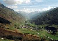


The Urserental (also Urseren, Ursern) is the valley of the upper Reuss in Uri, Switzerland, running southwest to northeast, from Realp to Hospental and Andermatt.
Separated from the main valley of Uri, it connects to the Valais via the Furkapass, to the Grisons via the Oberalppass and to the Ticino via the Gotthard Pass.
The valley was in possession of Disentis Abbey from 800. It was colonized by Walser settlers prior to the 12th century. The Blutgericht lay with the counts of Rapperswil from 1232, in 1283 passing to the house of Habsburg, and in 1317 to local nobility of Uri. In 1332, there was a skirmish between settlers and troops of the abbey's at Oberalp, resulting in a defeat of Disentis. Urseren became reichsfrei in 1382 and joined the Old Swiss Confederacy in 1410, and associated itself with Uri for purposes of defence and external representation, however retaining privileges as an independent territory. In 1649, Urseren bought itself out of the last remaining ties to Disentis.
In 1798, Urseren became part of the canton of Waldstätten of the Helvetic Republic, and in 1803 became part of the canton of Uri. In 1946, there were clashes between locals and the Swiss Army over a disputed dam project which intended to flood the entire valley.
References
- Hans Stadler: Ursern in German, French and Italian in the online Historical Dictionary of Switzerland, 2011.