Ulriksbanen
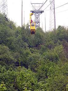
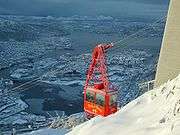
Ulriksbanen is a passenger aerial tramway in Bergen, Norway. It connects the mountain Ulriken to the city, and is frequently used by tourists as well as locals. The tramway was first thought of by Frithjof Meidell Andersen in 1954, and a company was established in 1959. After having been constructed by a Swiss company, Ulriksbanen opened in 1961.
Accidents
The first and only accident in the history of Ulriksbanen happened in 1974. During the six first months of the year, a record-breaking 91,000 had travelled with the tramway. On 9 July, one of the gondolas detached and got hurled into the ground, killing four. Following the accident, the tramway closed and did not reopen until 1979. The local department of the Norwegian Mountain Touring Association took over the operation in 1983, but was forced to keep the tramway closed in 1988 and 1989 due to a lack of funds.
On 10 January 2006, Ulriksbanen was shut down when one of the track cables derailed.[1] On 4 March 2006, it was reopened,[2] continuing to operate until August the same year when the police was forced to close the tramway after a safety inspection.[3] Ulriksbanen was reopened on 1 April 2007.[4] In January 2008, the tramway was again shut down due to fears that the cables could be too damaged for Ulriksbanen to operate safely.[5] The Ulriksbanen was reopened for public on the 1 May 2009.[6]
References
- Gunnar Hagen Hartvedt (1994). "Ulriksbanen". Bergen Byleksikon: 475–476.
- ↑ Berit Kvalheim (2006). "Ulriksbanen stengt på ubestemt tid" (in Norwegian). bt.no. Retrieved 2008-01-02.
- ↑ Arne Colliander (2006). "- Deilig å være i gang igjen" (in Norwegian). bt.no. Retrieved 2008-01-02.
- ↑ Liv Solli Okkenhaug (2006). "Ulriksbanen stengt" (in Norwegian). bt.no. Retrieved 2008-01-02.
- ↑ Espen Kragh (2007). "Se, nå går den!" (in Norwegian). ba.no. Retrieved 2008-01-02.
- ↑ Rune Christophersen (2008). "Stenges igjen" (in Norwegian). bt.no. Retrieved 2008-01-02.
- ↑ Målfrid Bordvik (2009). "Nye Ulrikens første turister" (in Norwegian). bt.no. Retrieved 2009-05-02.
External links
Coordinates: 60°22′26.40″N 5°21′49.59″E / 60.3740000°N 5.3637750°E