Ukanafun
| Ukanafun | |
|---|---|
| LGA | |
 Ukanafun Location in Nigeria | |
| Coordinates: 4°54′0″N 7°36′0″E / 4.90000°N 7.60000°ECoordinates: 4°54′0″N 7°36′0″E / 4.90000°N 7.60000°E | |
| Country |
|
| State | Akwa Ibom State |
| Time zone | WAT (UTC+1) |
Ukanafun is located in the south east of Nigeria and is a Local Government Area of Akwa Ibom State.
Ukanafun was carved out from Abak and Opobo divisions of Cross River State. The Nigerian Civil war depopulated the area and slowed down economic activities of the people.
The Ukanafun area is yet to recover from the shock of the civil war not to talk of ethnic politics that have made one of the great commercial nerve centres of the people of Annang extraction almost completely reduced to the background due to the absence of a good road network that once characterised the area in the time of the colonial masters. Palm produce used to be the major economic activity of the people. Ntak Ibesit now under Oruk Anam LGA used to be the centre of the palm kernel trade at its Ekpene Okpo river port which served as an excellent trade route to Opobo. Today there is no port in Ntak Ibesit. Today, Ukanafun is made up of a host of villages some of which are: Idung Nnekke, Nkek, Nkek Idim, Afaha Obo, Ikot Esien, Nyak Ibah, Ikot Andem, Ikot Etim, Ikot Oku Usung, Ikot Uko, Ikot Akpa Ntuen, Ikot Inyang Abia, Ntak Afafha, Nto Okon, Usung Atiat, Ikot Udo Osiom, Ikot Akpa Idem, etc.
References
State capital: Uyo | ||
| LGAs | 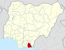 | |