Uithof
De Uithof is a part of the city of Utrecht, which contains the Utrecht Science Park, the campus area of Utrecht University, the vocational university Hogeschool Utrecht and the academic hospital University Medical Center Utrecht (UMCU). It is located to the east of the city. Except for the faculties of Law, Humanities and the University College, which are located in the inner city of Utrecht, most of the buildings of the University are located in De Uithof. De Uithof also contains the main university library, student housing, botanical gardens, shops and a restaurant.
There is a bus line to the inner city and the train station, served by bi-articulated buses. Construction of extensive park-and-ride facilities, designed by KCAP, began in August 2011.[1] In 2013 the construction of the Uithoflijn, an extension of the light rail network between the city and De Uithof, began construction, and should be completed in 2018.[2]
Buildings in De Uithof

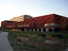
Some of the buildings on De Uithof have an unusual architecture, and some have won prizes for their architecture. The Educatorium, designed by Rem Koolhaas (1997), contains a glass-bottomed walking bridge and circular walls. The Minnaertgebouw used to contain a large basin that was used to collect rain water, and its outer wall is supported by large characters, M, I, N, N, A, E, R, T. The Universiteitsbibliotheek (University Library), designed by Wiel Arets (2004), is known for its spacious interiour and black exterior. Many of the buildings are named after scientists that worked in a field which is similar to the specialization of the occupants of the building.
University buildings
This is a partial list of buildings at the Utrecht Science Park. The official names of all of the buildings are found here.[3] The Dutch word "gebouw" means "building".
- Aardwetenschappengebouw (Earth Sciences Building)
- Bestuursgebouw – the seat of the board of Utrecht University
- Buys Ballotgebouw (BBG), named after meteorologist C. H. D. Buys Ballot
- Caroline Bleekergebouw, named after physicist Caroline Bleeker
- David de Wiedgebouw, named after farmacologist David de Wied
- Educatorium
- Hans Freudenthalgebouw, named after mathematician Hans Freudenthal
- Hijmans van den Berghgebouw, named after physician Abraham Albert Hijmans van den Bergh – (bio)medical education
- Kruytgebouw (formerly known as Trans-3), named after chemist Hugo R. Kruyt
- Leonard S. Ornsteinlaboratorium, named after physicist Leonard Ornstein
- Marinus Ruppertgebouw (formerly known as Trans-1), named after pedagogue Marinus Ruppert, who started the development of buildings on De Uithof
- Martinus J. Langeveldgebouw (formerly known as Centrumgebouw Zuid), named after Martinus J. Langeveld, who started the Faculty of Social Sciences of the university
- Minnaertgebouw, named after astronomer Marcel Minnaert
- Nicolaas Bloembergengebouw, named after physicist Nicolaas Bloembergen – NMR spectroscopy
- Robert J. Van de Graafflaboratorium, named after physicist and instrument maker Robert J. Van de Graaff
- Sjoerd Groenmangebouw (formerly known as Centrumgebouw Noord), named after sociologist Sjoerd Groenman
- Stratenum, named after physician W. van Straaten – medical education
- Universiteitsbibliotheek Uithof (Library)
- Willem C. van Unnikgebouw (formerly known as Trans-2), named after bible scholar Willem C. van Unnik
| Wikimedia Commons has media related to Uithof. |
Student housing
- Cambridgelaan, built in 1998. 1002 occupants.
- De Bisschoppen (the Bishops,) built in 2006. 552 occupants.
- Casa Confetti, built in 2008. 377 occupants.
- Johanna, build in 2015.
References
- ↑ "Start bouw grootste parkeergarage Utrecht". Architectuur.org. 29 August 2011. Retrieved 3 September 2011.
- ↑ "Home - De Uithoflijn". uithoflijn.nl. Retrieved 31 March 2015.
- ↑ "Gebouwen". uu.nl. Retrieved 29 March 2015.
Coordinates: 52°05′11″N 5°10′21″E / 52.08639°N 5.17250°E