Udachny
| Udachny (English) Удачный (Russian) Удачнай (Yakut) | |
|---|---|
|
- Town[1] - Town under district jurisdiction[1] | |
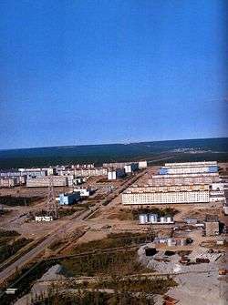 View of Udachny | |
_Republic_(2008-03).svg.png) Location of the Sakha (Yakutia) Republic in Russia | |
 Udachny | |
|
| |
.png) |
|
|
| |
| Administrative status (as of June 2009) | |
| Country | Russia |
| Federal subject | Sakha Republic[1] |
| Administrative district | Mirninsky District[1] |
| Town | Udachny[1] |
| Administrative center of | Town of Udachny[1] |
| Municipal status (as of April 2012) | |
| Municipal district | Mirninsky Municipal District[2] |
| Urban settlement | Udachny Urban Settlement[2] |
| Administrative center of | Udachny Urban Settlement[2] |
| Head | Artur Prikhodko |
| Statistics | |
| Population (2010 Census) | 12,613 inhabitants[3] |
| Time zone | YAKT (UTC+09:00)[4] |
| Founded | 1968 |
| Town status since | 1987[1] |
| Postal code(s)[5] | 678188 |
| Dialing code(s) | +7 41136 |
|
| |
| Udachny on Wikimedia Commons | |
| 2010 Census | 12,613[3] |
|---|---|
| 2002 Census | 15,698[6] |
| 1989 Census | 19,603[7] |
| 1979 Census | 11,604[8] |
Udachny (Russian: Удачный; IPA: [ʊˈdatɕnɨj], lit. successful or lucky; Yakut: Удачнай, Udacnay) is a town in Mirninsky District of the Sakha Republic, Russia, located on the Markha River, 508 kilometers (316 mi) from Mirny, the administrative center of the district. As of the 2010 Census, its population was 12,613.[3]
History

The Udachnaya pipe diamond deposit was discovered in 1955. Due to its isolated location, it was not exploited until the 1960s. In conjunction with the beginnings of diamond production, the urban-type settlement of Udachny was founded in 1968; town status was granted to it in 1987.[1]
As part of a plan to create the basin for a tailings dam for the nearby diamond mine, a 1.7 kiloton atomic bomb was detonated 98 meters (322 ft) underground near Udachny on October 2, 1974. Original plans had called for eight similar explosions to be conducted; however, due to radioactive fallout being far greater than expected, the project was halted after the first blast. The shaft in which the explosion was held was not plugged until eighteen years later, with an estimated 7-to-20-meter (23 to 66 ft) thick concrete sarcophagus.[9]
Administrative and municipal status
As an inhabited locality, Udachny is classified as a town under district jurisdiction.[1] Within the framework of administrative divisions, it is, together with one rural locality (the selo of Polyarny), incorporated within Mirninsky District as the Town of Udachny.[1] As a municipal division, the Town of Udachny is incorporated within Mirninsky Municipal District as Udachny Urban Settlement.[2]
Economy
Diamond mining remains the principal economic activity in the town. Udachny is the second most important diamond production site after Mirny for the state-owned ALROSA corporation.
Climate
Udachny has an extreme subarctic climate (Köppen climate classification Dfd). Winters are extremely cold, with average temperatures from −43.6 °C (−46.5 °F) to −35.2 °C (−31.4 °F) in January, while summers are mild, with average temperatures from +8.4 °C (47.1 °F) to +20.1 °C (68.2 °F) in July. Precipitation is quite low, but is significantly higher in summer than at other times of the year.
| Climate data for Udachny | |||||||||||||
|---|---|---|---|---|---|---|---|---|---|---|---|---|---|
| Month | Jan | Feb | Mar | Apr | May | Jun | Jul | Aug | Sep | Oct | Nov | Dec | Year |
| Average high °C (°F) | −35.2 (−31.4) |
−30.3 (−22.5) |
−17.6 (0.3) |
−6.1 (21) |
3.8 (38.8) |
15.6 (60.1) |
20.1 (68.2) |
15.8 (60.4) |
6.3 (43.3) |
−7.7 (18.1) |
−25.4 (−13.7) |
−31.5 (−24.7) |
−7.68 (18.16) |
| Daily mean °C (°F) | −39.4 (−38.9) |
−35.2 (−31.4) |
−24.3 (−11.7) |
−12.6 (9.3) |
−0.8 (30.6) |
10.1 (50.2) |
14.2 (57.6) |
10.2 (50.4) |
2.1 (35.8) |
−11.5 (11.3) |
−29.8 (−21.6) |
−36.0 (−32.8) |
−12.75 (9.07) |
| Average low °C (°F) | −43.6 (−46.5) |
−40.0 (−40) |
−30.9 (−23.6) |
−19.0 (−2.2) |
−5.4 (22.3) |
4.6 (40.3) |
8.4 (47.1) |
4.6 (40.3) |
−2.0 (28.4) |
−15.3 (4.5) |
−34.1 (−29.4) |
−40.4 (−40.7) |
−17.76 (0.04) |
| Average precipitation mm (inches) | 12 (0.47) |
9 (0.35) |
11 (0.43) |
16 (0.63) |
27 (1.06) |
46 (1.81) |
59 (2.32) |
50 (1.97) |
34 (1.34) |
28 (1.1) |
20 (0.79) |
14 (0.55) |
326 (12.82) |
| Source: http://en.climate-data.org/location/30312/ | |||||||||||||
References
Notes
- 1 2 3 4 5 6 7 8 9 10 Registry of the Administrative-Territorial Divisions of the Sakha Republic
- 1 2 3 4 Law #173-Z #353-III
- 1 2 3 Russian Federal State Statistics Service (2011). "Всероссийская перепись населения 2010 года. Том 1" [2010 All-Russian Population Census, vol. 1]. Всероссийская перепись населения 2010 года (2010 All-Russia Population Census) (in Russian). Federal State Statistics Service. Retrieved June 29, 2012.
- ↑ Правительство Российской Федерации. Федеральный закон №107-ФЗ от 3 июня 2011 г. «Об исчислении времени», в ред. Федерального закона №271-ФЗ от 03 июля 2016 г. «О внесении изменений в Федеральный закон "Об исчислении времени"». Вступил в силу по истечении шестидесяти дней после дня официального опубликования (6 августа 2011 г.). Опубликован: "Российская газета", №120, 6 июня 2011 г. (Government of the Russian Federation. Federal Law #107-FZ of June 31, 2011 On Calculating Time, as amended by the Federal Law #271-FZ of July 03, 2016 On Amending Federal Law "On Calculating Time". Effective as of after sixty days following the day of the official publication.).
- ↑ Почта России. Информационно-вычислительный центр ОАСУ РПО. (Russian Post). Поиск объектов почтовой связи (Postal Objects Search) (Russian)
- ↑ Russian Federal State Statistics Service (May 21, 2004). "Численность населения России, субъектов Российской Федерации в составе федеральных округов, районов, городских поселений, сельских населённых пунктов – районных центров и сельских населённых пунктов с населением 3 тысячи и более человек" [Population of Russia, Its Federal Districts, Federal Subjects, Districts, Urban Localities, Rural Localities—Administrative Centers, and Rural Localities with Population of Over 3,000] (XLS). Всероссийская перепись населения 2002 года [All-Russia Population Census of 2002] (in Russian). Retrieved August 9, 2014.
- ↑ Demoscope Weekly (1989). "Всесоюзная перепись населения 1989 г. Численность наличного населения союзных и автономных республик, автономных областей и округов, краёв, областей, районов, городских поселений и сёл-райцентров" [All Union Population Census of 1989: Present Population of Union and Autonomous Republics, Autonomous Oblasts and Okrugs, Krais, Oblasts, Districts, Urban Settlements, and Villages Serving as District Administrative Centers]. Всесоюзная перепись населения 1989 года [All-Union Population Census of 1989] (in Russian). Институт демографии Национального исследовательского университета: Высшая школа экономики [Institute of Demography at the National Research University: Higher School of Economics]. Retrieved August 9, 2014.
- ↑ "Всесоюзная перепись населения 1979 г. Национальный состав населения по регионам России. (All Union Population Census of 1979. Ethnic composition of the population by regions of Russia.)". Всесоюзная перепись населения 1979 года (All-Union Population Census of 1979) (in Russian). Demoscope Weekly (website of the Institute of Demographics of the State University—Higher School of Economics. 1979. Retrieved 2008-11-25.
- ↑ Report on the underground explosion near Udachny in 1974 and its status in 2000 (Russian)
Sources
- Official website of the Sakha Republic. Registry of the Administrative-Territorial Divisions of the Sakha Republic. Mirninsky District. (Russian)
- Государственное Собрание (Ил Тумэн) Республики Саха (Якутия). Закон №173-З №353-III от 30 ноября 2004 г. «Об установлении границ и о наделении статусом городского и сельского поселений муниципальных образований Республики Саха (Якутия)», в ред. Закона №1058-З №1007-IV от 25 апреля 2012 г. «О внесении изменений в Закон Республики Саха (Якутия) "Об установлении границ и о наделении статусом городского и сельского поселений муниципальных образований Республики Саха (Якутия)"». Вступил в силу со дня официального опубликования. Опубликован: "Якутия", №245, 31 декабря 2004 г. (State Assembly (Il Tumen) of the Sakha (Yakutia) Republic. Law #173-Z No. 353-III of November 30, 2004 On Establishing the Borders and on Granting the Urban and Rural Settlement Status to the Municipal Formations of the Sakha (Yakutia) Republic, as amended by the Law #1058-Z No. 1007-IV of April 25, 2012 On Amending the Law of the Sakha (Yakutia) Republic "On Establishing the Borders and on Granting the Urban and Rural Settlement Status to the Municipal Formations of the Sakha (Yakutia) Republic". Effective as of the day of the official publication.).