Uchtepa
| Uchtepa Uch Tepa | |
|---|---|
| District of Tashkent | |
 | |
| Country |
|
| Municipality | Tashkent |
| Established | 1981 |
| Area[1] | |
| • Total | 28.2 km2 (10.9 sq mi) |
| Population (2009)[1] | |
| • Total | 237,000 |
| • Density | 8,400/km2 (22,000/sq mi) |
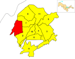
Uchtepa (also spelled Uch Tepa) is one of 11 districts (tuman) of Tashkent, the capital of Uzbekistan.
Overview
The district, located in the western suburb, was established in 1981 with the name of Akmal-Ikramov.[2]
Uchtepa borders with the districts of Shaykhontohur and Chilanzar. It borders also with Tashkent Province and its northern area is close to the Uzbek frontier with South Kazakhstan Province, in Kazakhstan.
References
- 1 2 (Russian) Statistics of the subdivisions of Tashkent
- ↑ Sadikov, A C; Akramob Z. M., Bazarbaev, A., Mirzlaev T.M., Adilov S. R., Baimukhamedov X. N., et al. (in Russian) (72x112). Geographical Atlas of Tashkent (Ташкент Географический Атлас) (2 ed.). Moscow. p. 64.
External links
![]() Media related to Districts of Tashkent at Wikimedia Commons
Media related to Districts of Tashkent at Wikimedia Commons
Coordinates: 41°17′49″N 69°10′52″E / 41.2970°N 69.1810°E
This article is issued from Wikipedia - version of the 10/23/2014. The text is available under the Creative Commons Attribution/Share Alike but additional terms may apply for the media files.