U.S. Route 141
| ||||||||||
|---|---|---|---|---|---|---|---|---|---|---|
|
US 141 highlighted in red | ||||||||||
| Route information | ||||||||||
| Auxiliary route of US 41 | ||||||||||
| Maintained by WisDOT and MDOT | ||||||||||
| Length: | 168.82 mi[lower-alpha 1] (271.69 km) | |||||||||
| Existed: | November 11, 1926[1] – present | |||||||||
| Tourist routes: |
| |||||||||
| Major junctions | ||||||||||
| South end: |
| |||||||||
| ||||||||||
| North end: |
| |||||||||
| Location | ||||||||||
| States: | Wisconsin, Michigan | |||||||||
| Counties: |
WI: Brown, Oconto, Marinette; Florence MI: Dickinson; Iron, Baraga | |||||||||
| Highway system | ||||||||||
| ||||||||||
.svg.png)
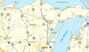
US Highway 141 (US 141) is a north–south United States Numbered Highway in the states of Wisconsin and Michigan. The highway runs north-northwesterly from an interchange with Interstate 43 (I-43) in Bellevue, Wisconsin, near Green Bay, to a junction with US 41/M-28 near Covington, Michigan. In between, it follows city streets in Green Bay and has a concurrent section with US 41 in Wisconsin. North of Green Bay, US 141 is either a freeway or an expressway into rural northern Wisconsin before downgrading to an undivided highway. In Michigan, US 141 is an undivided highway that runs through rural woodlands. The highway has two segments in each state; after running through Wisconsin for about 103 miles (166 km), it crosses into Michigan for approximately another 8 miles (13 km). After that, it crosses back into Wisconsin for about 14 1⁄2 miles (23 km) before crossing the state line one last time. The northernmost Michigan section is about 43 1⁄2 miles (70 km), making the overall length about 169 miles (272 km).
When the US Highway System was formed on November 11, 1926, US 141 ran from Milwaukee to Green Bay, and one segment of the modern highway in Michigan was originally designated US 102. This other designation was decommissioned in 1928 when US 141 was extended north from Green Bay into Michigan. Michigan has rebuilt the highway in stages over the years to smooth out sharp curves in the routing. Since the 1960s, the section south of Green Bay has been converted into a freeway in segments. US 141 has ended southeast of Green Bay in Bellevue since the 1980s—the southern freeway segment was redesignated as I-43. The section north of Abrams, Wisconsin, was converted to a freeway in the opening years of the 21st century, with an additional divided-highway section opening a few years later.
Route description
As a bi-state highway, US 141 is a state trunk highway in Wisconsin and a state trunkline highway in Michigan. In Wisconsin, the segment through the Green Bay area is not on the National Highway System (NHS),[2] except for about four blocks along Broadway Avenue that is part of an intermodal connector with the Port of Green Bay.[3] The NHS is a network of roads important to the country's economy, defense, and mobility.[4] From the Green Bay suburb of Howard northward, including the entire length through Michigan, US 141 is a part of the NHS.[5][6] From the I-43 interchange in Howard north to the split at Abrams, US 141 is also a part of the Lake Michigan Circle Tour (LMCT), a tourist route that surrounds Lake Michigan.[7]
Green Bay to Niagara

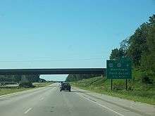
US 141 starts at an interchange with I-43 southeast of Green Bay in the suburb of Bellevue. From the terminus at exit 178, US 141 runs north to Main Street, and then northwesterly along Main Street through town. Wisconsin Highway 29 (WIS 29) merges with US 141 at an intersection on the northwest side of Bellevue, and the two highways run concurrently through residential subdivisions. Main Street passes over I-43 and continues to the north and into the city of Green Bay. US 141/WIS 29 crosses Baird Creek and runs along the banks of the East River. At the intersection with Monroe Avenue, WIS 29 turns south, joining WIS 54/WIS 57 while US 141 continues westward on Main Street to cross the Fox River on the Ray Nitschke Memorial Bridge. On the west side of the river, the highway follows Dousman Street for a block before turning north along Broadway Avenue for four blocks. From there, the highway follows Mather Street west to Velp Avenue. US 141 follows that street northwesterly and parallel to I-43 on the north side of Green Bay. This area is mostly residential with some businesses immediately on either side. In the suburb of Howard, US 141 merges onto the US 41 freeway via the interchange at exit 170. US 41/US 141 has an interchange for I-43 just south of the Duck Creek crossing.[8][9]
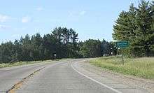
From Howard northward, the freeway runs through suburban Brown County to Suamico, parallel to a line of the Escanaba and Lake Superior Railroad (ELS), through a mixture of farm fields and residential subdivisions. There are frontage roads on both sides of the freeway to provide access to the properties immediately adjacent to US 41/US 141. There are a number of interchanges with county-maintained roads between Suamico and Abrams in Oconto County. At Abrams, US 141 splits from US 41 and heads northward while the latter freeway turns northeasterly. The landscape north of the split transitions to forest, and the freeway crosses the Oconto River in Stiles south of the interchange with WIS 22. The freeway bypasses Lena to the east and continues north through mixed farm fields and forest to the county line. North of the line, US 141 continues to the Marinette County communities of Coleman and Pound as an expressway. Through Coleman and Pound there is also a Business US 141. Past the latter town, US 141 transitions from expressway to a two-lane undivided highway.[7][8]
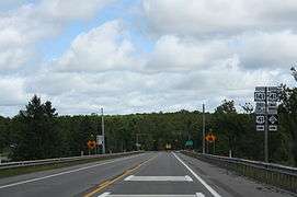
South of Crivitz, US 141 crosses the Peshtigo River. The highway crosses a branch line of the ELS on the east side of Crivitz and continues north through woodland to the community of Middle Inlet. North of town, the roadway turns northeasterly to the community of Wausaukee where it intersects WIS 180. From there, the highway passes through the communities of Amberg and Beecher before coming into Pembine. That town is where US 8 merges in from the west. The two highways run concurrently north and northeasterly to an intersection southeast of Niagara. US 8 separates to the east, and US 141 turns northwestly along River Street into Niagara. The highway then turns north along Roosevelt Road and over the Menominee River to exit the state of Wisconsin.[7][8]
Quinnesec northward
Once in Michigan, 1 mile (1.6 km) west of Quinnesec, US 141 meets and joins US 2. The two highways run concurrently westward into Iron Mountain along Stephenson Avenue, passing through a retail business corridor and into downtown. M-95 joins the two highways, and all three pass Lake Antoine. M-95 turns off north of town and US 2/US 141 crosses the Menominee River back into Wisconsin.[8][10]
US 2/US 141 makes a 14.5-mile (23.3 km) run through Florence County, passing the Spread Eagle Chain of Lakes. The highway serves the communities of Spread Eagle and Florence. The only junction with another state trunk highway in Wisconsin on the northern section is with the concurrent highways WIS 70 / WIS 101 in Florence. The highway crosses back into Michigan on a bridge over the Brule River south of Crystal Falls.[7][8]
Across the state line, the trunkline runs through forest near several smaller bodies of water such as Stager, Kennedy and Railroad lakes. The highway enters Crystal Falls on 5th Street. US 2/US 141 runs along the top of the hill in town and intersects the western terminus of M-69 next to the Iron County Courthouse. US 141 continues westward on Crystal Avenue and separates from the US 2 concurrency on the western edge of town. Running north and northwesterly, US 141 passes to the east of the Ottawa National Forest through rural Iron County. The highway crosses the Paint River and continues through forest to the community of Amasa. The trunkline crosses the Hemlock River on the west side of town. From there, US 141 runs northward into the southwest corner of Baraga County and also enters the Eastern Time Zone. West of Worm Lake, US 141 meets M-28 in the community of Covington. The two highways merge and run easterly for about 4 miles (6.4 km) before US 141 terminates at US 41; M-28 continues eastward, merging with US 41.[8][10]
History
Initial state highways
In 1918, when Wisconsin initially numbered its highway system, the route of what later became US 141 followed two separate state highways: WIS 17 from downtown Milwaukee to Manitowoc and WIS 16 from Manitowoc north to Green Bay. Segments that later became US 141 in Wisconsin were numbered WIS 15 between Green Bay and Abrams, and WIS 38 between Abrams and Wausaukee. North of Wausaukee, the future US Highway was an unnumbered secondary highway.[11] In 1919, Michigan signed its highway system,[12] but the state did not have a highway running south from Quinnesec to the state line. The highway from Quinnesec into Iron Mountain was part of M-12.[13] The segment through Florence County, Wisconsin, was WIS 69,[11] and from the Crystal Falls area north to Covington, the M-69 moniker was used.[13] In 1919, the WIS 38 designation was extended northward to Niagara and the state line.[14][15] The highway was straightened to eliminate a series of sharp curves between Crivitz and Beaver in 1921. The same year, WIS 17 was realigned between Sheboygan and Cedar Grove to run via Oostburg.[16][17] WIS 17 was also realigned in 1922 to follow a separate routing south of Port Washington; previously it was routed concurrently with WIS 57 in the area.[17][18] By 1924, maps showed an unnumbered roadway running south from Quinnesec to connect with WIS 57 at the state line.[19]
Conversion to a US Highway
| |
|---|---|
| Location: | Crystal Falls, MI–Covington, MI |
| Length: | 44.094 mi[20] (70.962 km) |
| Existed: |
November 11, 1926[1]– c. September 20, 1928[21] |
As originally proposed in 1925, several US Highways in Wisconsin and Michigan's Upper Peninsula were to be designated. However, the routings for two highways were different in Michigan in 1925 than on the final 1926 map. In the original plan, US 102 was supposed to replace M-15 from US 2 at Rapid River, continue via Marquette into Baraga County, and end at US 41 near Covington. At the same time, US 41 was to have followed US 2 from Powers to Crystal Falls and continued north to Covington.[22] However, when the final plan was approved and implemented on November 11, 1926,[1] US 41 took the eastern routing through Rapid River and Marquette, and US 102 was routed between Crystal Falls and Covington. In both plans, US 141 was only routed between Milwaukee and Green Bay, replacing WIS 17 and WIS 16.[23] At the time the two US Highways were created, WIS 57 was left untouched between Abrams and Niagara.[24] The next year, the M-57 designation was assigned to connect WIS 57 to Quinnesec, and US 8 was extended to follow US 141 to US 2 near Iron Mountain.[25]
By September 20, 1928, the extension of US 141 northward from Green Bay along WIS 57 to the Michigan state line had been approved,[21] and the signage was readied for installation the following month.[26] The US 102 designation was decommissioned when US 141 was also extended to replace M-57 from the state line, along US 2 to Crystal Falls and north to Covington.[27][28] US 8's eastern end was rerouted along a separate bridge over the Menominee River to a new terminus at an intersection with US 2 in Norway in 1929.[29][30] US 141 was fully paved in Wisconsin in the early 1930s; the last segment to be completed was between Pound and Abrams.[31][32]
The next major changes were made at the beginning of the 1930s in Michigan. A realignment in the Iron Mountain area shifted US 2/US 141 to a new bridge over the Menominee River between 1932 and 1934.[33][34] In 1940, a new routing from the state line north to Crystal Falls was opened; the previous routing was returned to local control.[35][36] The northern end was relocated near Covington in late 1948 or early 1949 when US 41 was realigned in the area.[37][38] This terminus was shifted again when US 141/M-28 was realigned in the area in late 1955 or early 1956.[39][40]
Freeway era
At about the same time as the realignments in Michigan, two-lane bypasses of Manitowoc and Port Washington in Wisconsin were opened in 1957.[41][42] The state built a divided-highway segment that opened the following year running from the Milwaukee area northward to the Ozaukee–Milwaukee county line.[42][43] The highway was rerouted to run further inland, bypassing Haven, Wisconsin, in 1959.[43][44] In late 1961, the highway in Michigan was rebuilt in northern Iron and southern Baraga counties between Amasa and Covington as the state smoothed out sharp corners in the routing and finished paving US 141;[45][46] a similar project was completed in 1972 south of Amasa to Crystal Falls.[47][48]
Wisconsin proposed an addition to the Interstate Highway System in the 1950s to connect Green Bay, the state's third-largest city, to the system. Variations on this proposal included using either the US 41 or US 141 corridors, or a new corridor in between. This request was rejected in the 1950s, but it was approved in the 1960s. After approval, the state started the process to convert US 141 between Milwaukee and Abrams into a freeway.[49] The first segments of freeway were opened in the Milwaukee area, starting in 1963 between Locust Street and Good Hope Road.[50][51] The following year, an extension of the freeway opened southward from Locust to North Avenue.[51][52] By 1965, the bypass of Sheboygan was opened;[49] the Milwaukee area freeway was extended northward to Brown Deer Road the following year.[53][54] Another freeway segment in the Milwaukee area opened in 1967, extending northward to Grafton in Ozaukee County.[55][56] The last section of US 141 in the city of Milwaukee to open as a freeway was completed in 1968 when I-94 was finished through downtown; at the same time, US 141 was extended southward from North Avenue to meet I-94.[57][58]

Another freeway section from north of Green Bay to Suamico was opened in 1971.[59][60] In 1972, the divided-highway segment between Suamico and Abrams opened,[60][61] and the state started the construction of additional freeways between Green Bay and Milwaukee.[49] The bypasses of Sheboygan and Cedar Grove were converted to full freeways in 1973.[61][62] Another segment of freeway opened in 1975 that bypassed Port Washington and connected the freeway sections that ended near Grafton and Cedar Grove.[63][64] I-43 was first designated on the 1978 official state highway map along US 141 from Milwaukee to Sheboygan; missing segments of I-43 between Green Bay and Milwaukee are shown as either under construction or proposed.[65] By 1980, the northern bypass of Green Bay was under construction and I-43/US 141 was open from Maribel to Branch northwest of Manitowoc; US 141 was truncated to end at the northern end of the Sheboygan bypass.[66] I-43 was initially completed in 1981,[49] and the southern terminus of US 141 was moved again, truncating the highway to end in Bellevue by 1983.[67]
In 1986, the states in the Great Lakes region created the LMCT as part of a larger program of tourist routes in the region;[68] US 141 carries the LMCT between the northern I-43 junction in the Green Bay area north to the split with US 41 at Abrams.[7] In the first years of the 21st century, US 141 was expanded to a four-lane expressway northward from Abrams to Oconto Falls.[69][70] A further upgrade in 2006 expanded the highway to four-lanes northward to Beaver.[71][72] On April 7, 2015, the segment of US 141 that runs concurrently with US 41 on the west side of Green Bay designated a part of I-41 by the Federal Highway Administration.[73]
Major intersections
| State | County | Location | mi[lower-alpha 2] | km | Exit | Destinations | Notes |
|---|---|---|---|---|---|---|---|
| Wisconsin | Brown | Town of Ledgeview | 0.00 | 0.00 | Exit 178 on I-43 | ||
| 0.81 | 1.30 | Eastern end of WIS 29 concurrency | |||||
| Green Bay | 7.72 | 12.42 | Western end of WIS 29 concurrency | ||||
| Howard | 11.06 | 17.80 | Military Avenue | Former Bus. US 41 | |||
| 12.01 | 19.33 | 170 | Southern end of I-41/US 41 concurrency; exit numbers follow US 41's mileage | ||||
| 12.39 | 19.94 | 171 | Northern end of I-41 concurrency; southern end of LMCT concurrency; I-43 exit 192 | ||||
| Town of Suamico | 14.45 | 23.26 | 173 | ||||
| 17.50 | 28.16 | 176 | |||||
| Oconto | Town of Little Suamico | 20.48 | 32.96 | 179 | Brown Road | ||
| 23.49 | 37.80 | 182 | |||||
| Town of Abrams | 26.53 | 42.70 | 185 | ||||
| 28.12 | 45.25 | 187 | Northern end of US 41 and LMCT concurrencies | ||||
| Town of Stiles | 35.12 | 56.52 | — | Diamond interchange | |||
| Town of Lena | 39.70 | 63.89 | — | Diamond interchange | |||
| Oconto–Marinette county line | Lena–Pound town line | 44.83 | 72.15 | Northern end of freeway; southern end of expressway | |||
| Marinette | Coleman | 47.43 | 76.33 | — | Diamond interchange | ||
| Town of Beaver | 51.72 | 83.24 | — | Diamond interchange | |||
| 53.10 | 85.46 | Northern end of expressway | |||||
| Crivitz | 60.58 | 97.49 | Former western terminus for WIS 158 | ||||
| Wausaukee | 70.41 | 113.31 | |||||
| Town of Pembine | 88.76 | 142.85 | Southern end of US 8 concurrency | ||||
| Town of Niagara | 98.28 | 158.17 | Northern end of US 8 concurrency | ||||
| Menominee River | 102.87 0.000 | 165.55 0.000 | State line | ||||
| Michigan | Dickinson | Breitung Township | 1.132 | 1.822 | Eastern end of US 2 concurrency | ||
| Iron Mountain | 3.620 | 5.826 | Southern end of M-95 concurrency | ||||
| Breitung Township | 7.227 | 11.631 | Northern end of M-95 concurrency | ||||
| Menominee River | 7.892 0.00 | 12.701 0.00 | State line | ||||
| Wisconsin | Florence | Town of Florence | 3.91 | 6.29 | |||
| Brule River | 14.46 0.000 | 23.27 0.000 | State line | ||||
| Michigan | Iron | Crystal Falls | 10.030 | 16.142 | Western terminus of M-69 | ||
| Crystal Falls Township | 11.186 | 18.002 | Northern end of US 2 concurrency | ||||
| Baraga | Covington | 39.448 | 63.485 | Western end of M-28 concurrency | |||
| Covington Township | 43.602 | 70.171 | Eastern end of M-28 concurrency | ||||
1.000 mi = 1.609 km; 1.000 km = 0.621 mi
| |||||||
Business route
| |
|---|---|
| Location: | Coleman–Pound |
| Length: | 4.5 mi[76] (7.2 km) |
| Existed: | 2006[71][72]–present |
Business U.S. Highway 141 (Bus. US 141) is a business loop of US 141 that runs through the communities of Coleman and Pound. The loop follows County Trunk Highway B (CTH-B) northeasterly from the US 141 expressway into downtown Coleman and then turns northward near Coleman High School. Bus. US 141 continues northward into Pound, crossing the Peshtigo River in between the two communities. North of Pound, the loop crosses over US 141 on 21st Road and continues to an intersection with WIS 64. The business loop follows WIS 64 back to an interchange on US 141 northwest of Pound where the loop terminates.[76]
In 2006, the US 141 expressway was extended northward near Beaver, and the former route of US 141, plus a connector roadway southwest of downtown Coleman was designated as a business loop.[71][72] This route does not appear on the official Wisconsin Department of Transportation maps, so it is a locally designated business loop under local maintenance.[7]
See also
-
 Michigan Highways portal
 -
 U.S. Roads portal
 -
 Wisconsin portal
Footnotes
References
- 1 2 3 McNichol, Dan (2006). The Roads that Built America: The Incredible Story of the US Interstate System. New York: Sterling. p. 74. ISBN 1-4027-3468-9. OCLC 63377558.
- ↑ Federal Highway Administration (October 1, 2012). National Highway System: Green Bay, Wisconsin (PDF) (Map). Scale not given. Washington, DC: Federal Highway Administration. Retrieved July 18, 2013.
- ↑ Natzke, Stefan; Neathery, Mike & Adderly, Kevin (June 18, 2012). "Official NHS Intermodal Connector Listing: Wisconsin". National Highway System. Federal Highway Administration. Retrieved March 20, 2013.
- ↑ Natzke, Stefan; Neathery, Mike & Adderly, Kevin (September 26, 2012). "What is the National Highway System?". National Highway Administration. Federal Highway Administration. Retrieved January 1, 2013.
- ↑ Michigan Department of Transportation (April 23, 2006). National Highway System, Michigan (PDF) (Map). Scale not given. Lansing: Michigan Department of Transportation. Retrieved October 7, 2008.
- ↑ Federal Highway Administration (October 1, 2012). National Highway System: Wisconsin (PDF) (Map). Scale not given. Washington, DC: Federal Highway Administration. Retrieved July 18, 2013.
- 1 2 3 4 5 6 Wisconsin Department of Transportation (2010). Official State Highway Map (Map) (2010–11 ed.). Scale not given. Madison: Wisconsin Department of Transportation. §§ I4–I6, H3.
- 1 2 3 4 5 6 Google (January 4, 2012). "Overview Map of US 141" (Map). Google Maps. Google. Retrieved January 4, 2012.
- ↑ Wisconsin Department of Transportation (2010). Official State Highway Map (Map) (2010–11 ed.). Scale not given. Madison: Wisconsin Department of Transportation. Green Bay and Vicinity inset.
- 1 2 Michigan Department of Transportation (2010). Uniquely Michigan: Official Department of Transportation Map (Map). c. 1:975,000. Lansing: Michigan Department of Transportation. §§ C4–D4, D5. OCLC 42778335, 639960603.
- 1 2 Wisconsin Highway Commission (1918). Official Map of the State Trunk Highway System of Wisconsin (Map). [c. 1:1,010,000]. Madison: Wisconsin Highway Commission. §§ P8–Q11, Q11–P15. OCLC 38871736, 69119995. Retrieved November 14, 2010 – via Wisconsin Historical Society.
- ↑ "Michigan May Do Well Following Wisconsin's Road Marking System". The Grand Rapids Press. September 20, 1919. p. 10. OCLC 9975013.
- 1 2 Michigan State Highway Department (July 1, 1919). State of Michigan (Map). Scale not given. Lansing: Michigan State Highway Department. Upper Peninsula sheet. OCLC 15607244. Retrieved December 18, 2016 – via Michigan State University Libraries.
- ↑ Wisconsin Highway Commission (1919). Official Map of the State Trunk Highway System of Wisconsin (Map). [c. 1:1,010,000]. Madison: Wisconsin Highway Commission. §§ Q11–P15. OCLC 829862961, 911138596.
- ↑ Wisconsin Highway Commission (1920). Official Map of the State Trunk Highway System of Wisconsin (Map). Scale not given. Madison: Wisconsin Highway Commission. pp. 20–1, 26–7. §§ 4, 6. OCLC 5673515.
- ↑ Wisconsin Highway Commission (1921). Official Map of the State Trunk Highway System of Wisconsin (Map). Scale not given. Madison: Wisconsin Highway Commission. pp. 20–1, 26–7. §§ 4, 6.
- 1 2 Wisconsin Highway Commission (1922). Official Map of the State Trunk Highway System of Wisconsin (Map). Scale not given. Madison: Wisconsin Highway Commission. pp. 20–1, 26–7. §§ 4, 6.
- ↑ Wisconsin Highway Commission (1923). Official Map of the State Trunk Highway System of Wisconsin (Map). Scale not given. Madison: Wisconsin Highway Commission. pp. 20–1, 26–7. §§ 4, 6.
- ↑ Rand McNally (1924). "Auto Trails Map, District 8: Wisconsin, Northern Ill., Northern Mich." (Map). Commercial Atlas of America (55th ed.). Scale not given. Chicago: Rand McNally. pp. 326–7. OCLC 53626466.
- 1 2 Michigan Department of Transportation & Michigan Center for Shared Solutions and Technology Partnerships (2009). MDOT Physical Reference Finder Application (Map). Michigan Department of Transportation. Retrieved May 12, 2010.
- 1 2 "Continuation of Highway 141". The Manitowoc Herald-News. September 20, 1928. p. 13. OCLC 14635175. Retrieved July 21, 2014 – via NewspaperArchive.com. (subscription required (help)).
- ↑ Secretary of Agriculture (November 18, 1925). Report of Joint Board on Interstate Highways, October 30, 1925 (Report). US Department of Agriculture.
- ↑ Bureau of Public Roads & American Association of State Highway Officials (November 11, 1926). United States System of Highways Adopted for Uniform Marking by the American Association of State Highway Officials (Map). 1:7,000,000. Washington, DC: United States Geological Survey. OCLC 32889555. Retrieved November 7, 2013 – via University of North Texas Libraries.
- ↑ Wisconsin Highway Commission (1927). Official Highway Map of Wisconsin (Map). 1:950,400. Madison: Wisconsin Highway Commission.
- ↑ Michigan State Highway Department (December 1, 1927). Official Highway Service Map (Map). [c. 1:810,000]. Lansing: Michigan State Highway Department. OCLC 12701195, 79754957.
- ↑ "Extend Highway From Green Bay: Signs for Change Have Already Arrived for Use". The Manitowoc Times. October 22, 1928. p. 7. OCLC 14404502. Retrieved July 21, 2014 – via NewspaperArchive.com. (subscription required (help)).
- ↑ Michigan State Highway Department (May 1, 1928). Official Highway Service Map (Map). [c. 1:810,000]. Lansing: Michigan State Highway Department. OCLC 12701195, 79754957.
- ↑ Michigan State Highway Department (October 1, 1928). Official Highway Service Map (Map). [c. 1:810,000]. Lansing: Michigan State Highway Department. OCLC 12701195, 79754957.
- ↑ Rand McNally (1929). Junior Auto Road Map of Wisconsin (Map). Scale not given. Chicago: Rand McNally.
- ↑ Wisconsin Highway Commission (1930). Official Highway Map of Wisconsin (Map). 1:823,680. Madison: Wisconsin Highway Commission.
- ↑ Wisconsin Highway Commission (1932). Official Highway Map of Wisconsin (Map). 1:823,680. Madison: Wisconsin Highway Commission.
- ↑ Wisconsin Highway Commission (1934). Official Highway Map of Wisconsin (Map). 1:823,680. Madison: Wisconsin Highway Commission.
- ↑ Michigan State Highway Department & Rand McNally (April 1, 1932). Official Michigan Highway Map (Map). [c. 1:840,000]. Lansing: Michigan State Highway Department. § D5. OCLC 12701053.
- ↑ Michigan State Highway Department & Rand McNally (September 1, 1934). Official Michigan Highway Map (Map). [c. 1:850,000]. Lansing: Michigan State Highway Department. § D5. OCLC 12701143.
- ↑ Michigan State Highway Department & Rand McNally (July 15, 1940). Official Michigan Highway Map (Map) (Summer ed.). [c. 1:850,000]. Lansing: Michigan State Highway Department. § D4. OCLC 12701143. Retrieved December 18, 2016 – via Archives of Michigan.
- ↑ Michigan State Highway Department & Rand McNally (December 1, 1940). Official Michigan Highway Map (Map) (Winter ed.). [c. 1:850,000]. Lansing: Michigan State Highway Department. § D4. OCLC 12701143.
- ↑ Michigan State Highway Department (July 1, 1948). Official Highway Map (Map). [c. 1:918,720]. Lansing: Michigan State Highway Department. § B4. OCLC 12701120.
- ↑ Michigan State Highway Department (July 1, 1949). Michigan Official Highway Map (Map). [c. 1:918,720]. Lansing: Michigan State Highway Department. § B4. OCLC 12701120.
- ↑ Michigan State Highway Department (October 1, 1955). Official Highway Map (Map). [c. 1:918,720]. Lansing: Michigan State Highway Department. § B4. OCLC 12701120.
- ↑ Michigan State Highway Department (April 15, 1956). Official Highway Map (Map). [c. 1:918,720]. Lansing: Michigan State Highway Department. § B4. OCLC 12701120.
- ↑ State Highway Commission of Wisconsin (1957). Wisconsin Highway Map (Map). 1:887,040. Madison: State Highway Commission of Wisconsin. §§ I7–I9.
- 1 2 State Highway Commission of Wisconsin (1958). Wisconsin Highway Map (Map). 1:887,040. Madison: State Highway Commission of Wisconsin. §§ I7–I10.
- 1 2 State Highway Commission of Wisconsin (1959). Wisconsin Highway Map (Map). 1:887,040. Madison: State Highway Commission of Wisconsin. §§ I8, I10.
- ↑ State Highway Commission of Wisconsin (1960). Wisconsin Highway Map (Map). 1:887,040. Madison: State Highway Commission of Wisconsin. § I8.
- ↑ Michigan State Highway Department (1961). Official Highway Map (Map). [c. 1:918,720]. Lansing: Michigan State Highway Department. §§ B4–C4. OCLC 12701120, 51857665. (Includes all changes through July 1, 1961)
- ↑ Michigan State Highway Department (1962). Official Highway Map (Map). [c. 1:918,720]. Lansing: Michigan State Highway Department. §§ B4–C4. OCLC 12701120, 173191490.
- ↑ Michigan Department of State Highways (1972). Michigan, Great Lake State: Official Highway Map (Map). c. 1:918,720. Lansing: Michigan Department of State Highways. §§ C4–D4. OCLC 12701120.
- ↑ Michigan Department of State Highways (1973). Michigan, Great Lake State: Official Highway Map (Map). c. 1:918,720. Lansing: Michigan Department of State Highways. §§ C4–D4. OCLC 12701120, 81679137.
- 1 2 3 4 Natzke, Stefan & Adderly, Kevin (May 4, 2012). "Economic Development History of Interstate 43 Corridor". Economic Development. Federal Highway Administration. Retrieved March 20, 2013.
- ↑ State Highway Commission of Wisconsin (1963). Wisconsin Highway Map (Map). Scale not given. Madison: State Highway Commission of Wisconsin. Milwaukee and Vicinity inset.
- 1 2 State Highway Commission of Wisconsin (1964). Wisconsin Highway Map (Map). Scale not given. Madison: State Highway Commission of Wisconsin. Milwaukee and Vicinity inset.
- ↑ State Highway Commission of Wisconsin (1965). Wisconsin Highway Map (Map). Scale not given. Madison: State Highway Commission of Wisconsin. Milwaukee and Vicinity inset.
- ↑ State Highway Commission of Wisconsin (1966). Wisconsin Highway Map (Map). Scale not given. Madison: State Highway Commission of Wisconsin. Milwaukee and Vicinity inset. OCLC 904962050.
- ↑ State Highway Commission of Wisconsin (1967). Wisconsin Highway Map (Map). Scale not given. Madison: State Highway Commission of Wisconsin. Milwaukee and Vicinity inset.
- ↑ State Highway Commission of Wisconsin (1967). Wisconsin Highway Map (Map). Scale not given. Madison: State Highway Commission of Wisconsin. § I9.
- ↑ State Highway Commission of Wisconsin (1968). Wisconsin Highway Map (Map). Scale not given. Madison: State Highway Commission of Wisconsin. § I9.
- ↑ State Highway Commission of Wisconsin (1968). Wisconsin Highway Map (Map). Scale not given. Madison: State Highway Commission of Wisconsin. Milwaukee and Vicinity inset.
- ↑ State Highway Commission of Wisconsin (1969). Wisconsin Highway Map (Map). Scale not given. Madison: State Highway Commission of Wisconsin. Milwaukee and Vicinity inset.
- ↑ Wisconsin Department of Transportation Division of Highways (1971). Wisconsin Highway Map (Map). 1:823,680. Madison: Wisconsin Department of Transportation. § I6. OCLC 698331116, 233595194.
- 1 2 Wisconsin Department of Transportation Division of Highways (1972). Wisconsin Highway Map (Map). 1:823,680. Madison: Wisconsin Department of Transportation. § I6.
- 1 2 Wisconsin Department of Transportation Division of Highways (1973). Wisconsin Highway Map (Map). 1:823,680. Madison: Wisconsin Department of Transportation. §§ I6–I8.
- ↑ Wisconsin Department of Transportation Division of Highways (1974). Wisconsin Highway Map (Map). 1:823,680. Madison: Wisconsin Department of Transportation. § I8.
- ↑ Wisconsin Department of Transportation Division of Highways (1975). Wisconsin Highway Map (Map). 1:823,680. Madison: Wisconsin Department of Transportation. § I9.
- ↑ Wisconsin Department of Transportation Division of Highways (1976). Wisconsin Highway Map (Map). 1:823,680. Madison: Wisconsin Department of Transportation. § I9. OCLC 62715542, 846996281.
- ↑ Wisconsin Department of Transportation Division of Highways (1978). Wisconsin Highway Map (Map) (1978–79 ed.). 1:823,680. Madison: Wisconsin Department of Transportation. §§ I6–I10. OCLC 174123957.
- ↑ Wisconsin Department of Transportation Division of Highways (1980). Wisconsin Highway Map (Map) (1980–81 ed.). 1:823,680. Madison: Wisconsin Department of Transportation. §§ I6–I10. OCLC 613423704, 77526920.
- ↑ Wisconsin Department of Transportation Division of Highways (1983). Wisconsin Highway Map (Map) (1983–84 ed.). 1:823,680. Madison: Wisconsin Department of Transportation. §§ I6–I10. OCLC 713016540, 381172055.
- ↑ Davis, R. Matt (May 1, 1986). "Signs to Mark Lake Circle Tour". The Daily Mining Gazette. Houghton, MI. p. 16. OCLC 9940134.
- ↑ Wisconsin Department of Transportation (2001). Official State Highway Map (Map) (2001–02 ed.). 1:823,680. Madison: Wisconsin Department of Transportation. § I6.
- ↑ Wisconsin Department of Transportation (2003). Official State Highway Map (Map) (2003–04 ed.). 1:823,680. Madison: Wisconsin Department of Transportation. § I6.
- 1 2 3 Wisconsin Department of Transportation (2006). Official State Highway Map (Map) (2006–07 ed.). 1:823,680. Madison: Wisconsin Department of Transportation. §§ I5–I6.
- 1 2 3 Wisconsin Department of Transportation (2008). Official State Highway Map (Map) (2008–09 ed.). 1:823,680. Madison: Wisconsin Department of Transportation. §§ I5–I6. OCLC 694140563.
- ↑ US 41 Interstate Conversion Team (April 9, 2015). "US 41 Interstate Conversion: Wisconsin State Line–Green Bay, in Kenosha, Racine, Milwaukee, Waukesha, Washington, Dodge, Fond du Lac, Winnebago, Outagamie, and Brown Counties". Wisconsin Department of Transportation. Archived from the original on April 10, 2015.
- ↑ Wisconsin Department of Transportation Region 3 (May 14, 2009). State Trunk Highway Log for Region 3. Green Bay: Wisconsin Department of Transportation. pp. 544–562.
- ↑ Wisconsin Department of Transportation Region 4 (December 31, 2008). State Trunk Highway Log for Region 4 (XLS). Rhinelander: Wisconsin Department of Transportation.
- 1 2 Google (September 21, 2015). "Overview Map of Bus. US 141" (Map). Google Maps. Google. Retrieved September 21, 2015.
External links
| Wikimedia Commons has media related to |
 Geographic data related to US 141 at OpenStreetMap
- US 141 at Wisconsin Highways
- US 141 at Michigan Highways
- US 141 at US Ends
- Historic US 102 at Michigan Highways