U.S. Route 6 in Massachusetts
| |||||||
|---|---|---|---|---|---|---|---|
| Grand Army of the Republic Highway | |||||||
|
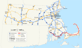
Map of the U.S. state of Massachusetts with U.S. Route 6 highlighted in red | |||||||
| Route information | |||||||
| Maintained by MassDOT | |||||||
| Length: | 117.952 mi[1] (189.825 km) | ||||||
| Existed: | 1926 – present | ||||||
| Major junctions | |||||||
| West end: |
| ||||||
|
| |||||||
| East end: |
| ||||||
| Highway system | |||||||
| |||||||
U.S. Route 6 in Massachusetts (US 6) is a 117.952-mile (189.83 km) long portion of the cross-country U.S. Route 6 highway connecting Providence, Rhode Island to Fall River, New Bedford, and Cape Cod. In the Fall River and New Bedford areas, US 6 is a secondary highway paralleling Interstate 195. On Cape Cod, US 6 is the primary highway interconnecting the towns of the area. The expressway section in this area is also known as the Mid-Cape Highway. The route is also alternatively signed as the "Grand Army of the Republic Highway."
Route description

Seekonk to the Sagamore Bridge
US 6 is a four-lane lane arterial road for approximately its first 54 miles (87 km) from the Rhode Island line (crossing into Massachusetts from East Providence to Seekonk) to the Cape Cod Canal, except for sections in New Bedford, where it runs along two one-way city streets, and Fall River, where it runs along a two-lane avenue.
US 6 enters Massachusetts into Seekonk, just south of Interstate 195. The first mile and a quarter passes through the busy Seekonk retail area. The route passes through Rehoboth and the western half of Swansea, with access to Interstate 195 at Massachusetts Route 136, which heads southward into Bristol County, Rhode Island. The road then crosses over I-195 at the latter's exit 3, just east of the terminus of Massachusetts Route 118. The road heads through the southern end of Somerset before crossing the Veterans Memorial Bridge over the Taunton River into the city of Fall River. On the Somerset end of the bridge, Massachusetts Route 103 ends and Massachusetts Route 138 joins US 6 to cross the bridge. Prior to late 2011, Routes 6 and 138 followed a previous alignment over the Brightman Street Bridge, which has since closed.
Once Route 6 enters Fall River, Route 138 leaves its concurrency and US 6 follows the two halves of Davol Street on either side of Massachusetts Route 79 before turning east on two-lane President Avenue, following up the Seven Hills to the Highlands neighborhood. At the end of President Avenue the road turns southward at a rotary (which also provides access to Massachusetts Route 24) onto four-lane Eastern Avenue. The road crosses over Interstate 195 one last time before turning eastward along Martine Street onto the "Narrows," the thin strip of land between the Watuppa Ponds that also carries the interstate between Fall River and Westport. Once over the Narrows, the road turns southeast, travelling on a straight line through the town. Interstate 195 can be accessed from Route 6 in Westport via Massachusetts Route 88, which crosses over Route 6 shortly before ending at the interstate. At the Dartmouth line, the road turns due east at the eastern end of Massachusetts Route 177. After passing through the Dartmouth retail area and two roads (Reed Road and Faunce Corner Road) that provide access to Interstate 195, the route passes into the city of New Bedford.
In New Bedford, the route splits just east of the terminus of Massachusetts Route 140 onto Kempton Street (eastbound) and Mill Street (westbound), two one-lane, one-way streets. The two halves join again to cross over Massachusetts Route 18 just before crossing the New Bedford – Fairhaven Bridge into the town of Fairhaven. After passing the terminus of Massachusetts Route 240 the route continues east into Mattapoisett and Marion along a four-lane road. Access to I-195 is provided in both towns along North Street in Mattapoisett and Massachusetts Route 105 in Marion. US 6 then crosses the Weweantic River into Wareham. In the central part of town the route turns southeast along Main Street, then east-northeast along Sandwich Road before beginning a concurrency with Massachusetts Route 28, with the first three-quarters of a mile being split one-way between east and west, just south of Massachusetts Route 25, the major connecting highway between Cape Cod and Interstates 195 and 495. The route passes through busy retail area of East Wareham before passing into the Buzzards Bay section of Bourne. The two routes split into east and west one-way sections again before Route 28 leaves the concurrency to cross the Bourne Bridge across the Cape Cod Canal. US 6 then follows the western side of the canal along the Scenic Highway before joining the right-of-way for Massachusetts Route 3 that ends at the Sagamore Bridge, in which US 6 crosses onto Cape Cod proper.
Cape Cod

After crossing the canal via the Sagamore Bridge, it becomes a freeway, known as the Mid-Cape Highway. From Bourne to Dennis at the cloverleaf interchange for exits 9A and 9B, the freeway is 4 lanes. The bridges from the Cape Cod Canal, to Oak Street in Barnstable Village (a half-mile west of Route 132), are unique in their construction since they are made out of concrete and granite. The road then reduces to a two-lane freeway with plastic stanchions posted on a small asphalt median. The two-lane freeway section has a secondary, less-formal name of "Suicide Alley", due to the high number of fatalities from head-on collisions before the median improvements were constructed. from 1989-1992. The Mid-Cape Highway carries a speed limit of 55 miles per hour (88.51 km/h) on the standard freeway and 50 miles per hour (80.47 km/h) on the two-lane freeway. It remains like this until Orleans, where the freeway ends at a large rotary.
Through Eastham and North Truro, US 6 is a four-lane surface street once again. Through Wellfleet and southern Truro, US 6 is a former 3-lane road converted to 2 lanes with broad shoulders. In Provincetown, US 6 is locally maintained, and ends as it started in the state, as a surface expressway once again before meeting Route 6A at the Cape Cod National Seashore. For the last several miles of its existence near Provincetown Route 6 east is actually heading west-southwest, though signage.
History

New England Interstate Route 3

Before the U.S. Highway system, the route from Rhode Island to Bourne, and from Orleans to Provincetown, was part of New England Interstate Route 3 (NE-3). Within the Upper Cape, however, NE-3 went along what is now Route 28 between Bourne and Orleans. The U.S. 6 designation was instead applied to the route on the north shore of Cape Cod, which was known as New England Interstate Route 6 before 1926 (now Route 6A).
Prior to the building of Interstate 195, the Fall River portion of Route 6 followed a different alignment. After entering the city via the Brightman Street Bridge, the route followed Davol Street to Turner Street, where it split to Durfee Street, a short portion of South Main Street and Pleasant Street (eastbound) and North Main Street to Bedford Street to Eastern Avenue (westbound, in reverse order). Both routes then took Pleasant Street east of Eastern Avenue to McGowan Street, which crossed into Westport and joined the current alignment of Route 6. The current alignment of these streets would be impossible now, as Turner Street's connection to Durfee Street is blocked, and both Pleasant Street and McGowan Street end just before the ramps between Interstate 195 and Route 24. Their former pathway into Westport is also gone, replaced by the path of the interstate. The only remnants of the old path is the odd turn Old Bedford Road takes before intersecting, having once been a separate street; the original alignment would have extended straight to Route 6.
U.S. Route 6 Bypass
When U.S. 6 was first routed through Provincetown in 1926, the highway was signed along the rather narrow Commercial Street. After the Provincetown U.S. 6 bypass was built, congestion and the increasing size of automobiles forced the town to post most of Commercial Street (all but the easternmost mile that hits the Truro line) as one-way westbound. Route 6A, when signed, was placed along the paralleling Bradford Street instead. There was an alternate plan at the time to make Bradford one-way westbound and Commercial one-way eastbound (which would have made both roads Route 6A), but this was rejected, as the town decided instead to let incoming traffic through the heavy Commercial Street (almost entirely pedestrian) business district.

U.S. 6 was briefly signed on current I-195 between Route 105 and Route 28; however, when I-195 was completed, and the I-195 designation took over that section of freeway, U.S. 6 reverted to its older route.
Formerly, U.S. 6 took both sides along the Cape Cod Canal (and was signed as "BYPASS 6"), but is now routed only on the north side (The south side is now signed "TO 6" from the Sagamore Bridge to the Bourne Bridge). However, a single "BYPASS 6" sign still exists along Sandwich Road just north of the Bourne Bridge rotary.
Future
MassDOT planned to change the exit numbers along the Mid-Cape Highway in 2016 as part of sign replacement contract to be run concurrently with a statewide project to convert freeway interchanges numbers to those based on highway mileposts.[2] The new exit numbers would have ranged from 55 in Sandwich to 88 in Orleans.[3] The first interchange on the Mid-Cape with Route 3 that is now signed as exits 1A-B would have be resigned as exits 55A-B, and so forth. However, in February 2016, when local Cape Cod officials found out about the plan, including the new numbers and that the signs would be larger than the current ones to be placed on overhead gantries, they complained to MassDOT and their local legislators. In response, MassDOT announced at a June 2016 public meeting that it listened to the public and were re-designing the signs to match the size of the current ones and that the exit numbers would not be changed, for now. The exit tabs and gore signs for the new signage would be designed however so the milepost numbers could fit on them, if changed, some time in the future.[4]
Major intersections
| County | Location | mi[1] | km | Old exit | New exit | Destinations | Notes |
|---|---|---|---|---|---|---|---|
| Bristol | Seekonk | 0.00 | 0.00 | Continuation into Rhode Island | |||
| 0.862– 0.894 | 1.387– 1.439 | ||||||
| Swansea | 4.687 | 7.543 | |||||
| 7.359– 7.620 | 11.843– 12.263 | Exit 3 on I-195 | |||||
| 7.748 | 12.469 | Southern terminus of Route 118 | |||||
| Somerset | 11.380 | 18.314 | Western terminus of concurrency with Route 138; eastern terminus of Route 103; interchange | ||||
| Taunton River | 11.380– 11.564 | 18.314– 18.610 | Veterans Memorial Bridge | ||||
| Fall River | 11.564– 11.885 | 18.610– 19.127 | Interchange; eastern terminus of concurrency with Route 138 | ||||
| 13.481 | 21.696 | President Avenue Rotary; exit 5 on Route 24 | |||||
| Westport | 17.834– 18.003 | 28.701– 28.973 | Interchange | ||||
| 21.119 | 33.988 | Eastern terminus of Route 177 | |||||
| Dartmouth | 21.595 | 34.754 | |||||
| 24.205 | 38.954 | ||||||
| New Bedford | 25.737 | 41.420 | Southern terminus of Route 140; exit 1 on Route 140 | ||||
| 27.534– 27.595 | 44.312– 44.410 | Westbound exit and eastbound entrance; southern terminus of Route 18 | |||||
| Acushnet River | 27.833– 27.925 | 44.793– 44.941 | Fish Island Bridge | ||||
| 28.207– 28.337 | 45.395– 45.604 | Fairhaven Bridge | |||||
| Fairhaven | 29.878 | 48.084 | Southern terminus of Route 240 | ||||
| Plymouth | Marion | 39.160 | 63.022 | Southern terminus of Route 105 | |||
| East Wareham | 45.76 | 73.64 | Western terminus of concurrency with Route 28 | ||||
| 46.108 | 74.204 | ||||||
| Barnstable | Buzzards Bay | 50.336 | 81.008 | Buzzards Bay Rotary; exit 3 on Route 25; eastern terminus of concurrency with Route 28 | |||
| Sagamore | 53.573 | 86.217 | 1A | Eastbound exit and westbound entrance; exits 1A-B on Route 3 | |||
| 53.673 | 86.378 | Western terminus of the Mid-Cape Highway | |||||
| 1B | Westbound exit and eastbound entrance; southern terminus of Route 3 | ||||||
| Scusset Beach Road – Sagamore Beach | Westbound exit and eastbound entrance | ||||||
| Cape Cod Canal | 54.753– 54.643 | 88.116– 87.939 | Sagamore Bridge | ||||
| Bourne | 54.643– 55.561 | 87.939– 89.417 | 1C | Westbound ramps feed into old routing of US 6 | |||
| Sandwich | 58.817 | 94.657 | 2 | ||||
| 60.762 | 97.787 | 3 | Quaker Meetinghouse Road – East Sandwich | ||||
| 62.943 | 101.297 | 4 | Chase Road – East Sandwich, West Barnstable | ||||
| Barnstable | 65.294 | 105.081 | 5 | ||||
| 68.101– 68.485 | 109.598– 110.216 | 6 | Serves Cape Cod Community College | ||||
| Yarmouth | 72.225 | 116.235 | 7 | Willow Street – Yarmouth Port, West Yarmouth | |||
| 74.485 | 119.872 | 8 | Union Street – Yarmouth, Dennis | ||||
| Dennis | 77.690 | 125.030 | 9 | Signed as exits 9A (south) and 9B (north) | |||
| Harwich | 81.792 | 131.631 | 10 | ||||
| 84.302 | 135.671 | 11 | |||||
| Orleans | 88.831 | 142.960 | 12 | ||||
| 90.880 | 146.257 | 13 | – | Orleans Rotary; exit number was removed in 1985; southern terminus of unsigned concurrency with Route 6A | |||
| Eastern terminus of the Mid-Cape Highway | |||||||
| Truro | 106.364– 106.637 | 171.176– 171.616 | Pamet Roads – Truro Center | Interchange | |||
| 109.451 | 176.144 | Northern terminus of unsigned concurrency with Route 6A | |||||
| 109.899– 110.282 | 176.865– 177.482 | Highland Road – North Truro, Highland Light | Interchange | ||||
| Provincetown | 116.366 | 187.273 | |||||
| 117.952 | 189.825 | Northern terminus of Route 6A | |||||
1.000 mi = 1.609 km; 1.000 km = 0.621 mi
| |||||||
See also
| Wikimedia Commons has media related to U.S. Route 6 in Massachusetts. |
Suffixed routes
-
 Massachusetts Route 6A, a more northern alignment of US 6 in Cape Cod prior to the construction of the Mid-Cape Highway
Related routes
-
 Massachusetts Route 28, the original alignment of New England Route 3 in Cape Cod
 - New England Interstate Route 3, the designation of US-6 (excluding the stretch from Bourne to Orleans) prior to 1926
-
 New England Interstate Route 6, the designation of US-6 between Bourne and Orleans, as well as of U.S. Route 3/Route 3 prior to 1926
References
- 1 2 MassDOT Planning Division. "Massachusetts Route Log Application". Massachusetts Department of Transportation. Retrieved January 23, 2016.
- ↑ Commonwealth of Massachusetts (2015). "COMMBUYS - Bid Solicitation FAP# HSIP-002S(874) Exit Signage Conversion to Milepost-Based Numbering System along Various Interstates, Routes and the Lowell Connector". Retrieved January 6, 2016.
- ↑ Robert H. Malme (2015). "US 6 (Mid Cape Highway) Exit List". Retrieved January 8, 2016.
- ↑ Doug Fraser (2016). "Route 6 Exit Numbers Status Quo For Now". Cape Cod Times. Retrieved October 10, 2016.
| Previous state: Rhode Island |
Massachusetts | Next state: Terminus |