U.S. Route 41
| |
|---|---|
 | |
| Route information | |
| Length: | 2,000 mi[1] (3,219 km) |
| Existed: | 1926[1] – present |
| Major junctions | |
| South end: |
|
| |
| North end: | Ft. Wilkins State Park near Copper Harbor, MI |
| Location | |
| States: | Florida, Georgia, Tennessee, Kentucky, Indiana, Illinois, Wisconsin, Michigan |
| Highway system | |

U.S. Route 41, also U.S. Highway 41 (US 41), is a north–south United States Highway that runs from Miami, Florida to the Upper Peninsula of Michigan. Until 1949, the part in southern Florida, from Naples to Miami, was US 94, which presently has the hidden designation of State Road 90 (SR 90) in addition to its signed number.
The highway's northern terminus is east of Copper Harbor, Michigan, at a modest cul-de-sac near Fort Wilkins Historic State Park at the tip of the Keweenaw Peninsula in the state's Upper Peninsula. Its southern terminus is in the Brickell neighborhood of Downtown Miami at an intersection with Brickell Avenue (US 1). It closely parallels Interstate 75 (I-75) from Naples, Florida, all the way through Georgia to Chattanooga, Tennessee.
Route description
Florida
In Florida, US 41 is paralleled by Interstate 75 all the way from Miami to Georgia (on the northern border), and I-75 has largely supplanted US 41 as a major highway.

Between Miami and Naples, US 41 cuts across the Florida peninsula, running through the vast Everglades wilderness. This section has been designated a National Scenic Byway. The byway runs east–west through the Big Cypress National Preserve, skirting the northern border of the Everglades National Park for about 20 miles (32 km). The part of the highway between Tampa and Miami is known as the Tamiami Trail (derived from the combination of Tampa and Miami, the road's two termini), thus, this section of the road is commonly known as the East Trail, as it runs east-west across the state, in contrast to the road's otherwise distinctively north-south route. In Naples, Route 41 changes direction at an intersection with 5th Avenue in Downtown Naples, turning from west to north towards Tampa (or from south to east towards Miami).

As the Trail moves into Hillsborough County the historic communities of Ruskin, Florida and Gibsonton, Florida are south Hillsborough County high points. Ruskin was founded by the Commongood Society. Highway 41 from Ruskin's Little Manatee River to Big Bend Rd (CR 672)has been designated by the Florida Senate as the Trooper Kenneth E. Flynt Hwy in Memory of Florida Trooper Flynt who was killed in the line of duty. [2] Gibsonton was populated by Carnival workers.
US 41 is in the process of being widened throughout the northern Tampa Bay suburbs. It is currently six lanes wide between Tampa, Lutz, and much of Land O' Lakes, and again between Garden Grove and Brooksville. It is also four lanes wide in Tampa south of BUS US 41, between a section north of Land O' Lakes, Masaryktown, and Garden Grove, and south of Inverness. A large portion of US 41 is co-designated along the unmarked State Road 45 between Belle Meade and High Springs.
From US 92 in Tampa to US 41 Business and State Road 676 near the unincorporated Palm River-Clair Mel, US 41 carries the unsigned State Road 599 designation. It contains the northwestern end of the Tamiami Trail at the SR 60 intersection. It is normally three lanes wide, but between Interstate 4 and the northern terminus of SR 569 it is only two lanes wide. The unsigned state highway is 5.6 miles (9.0 km) long. At the northern terminus, US 41 turns west. (If one continues straight, 40th Street leads to Busch Gardens Tampa Bay.) Major intersections include State Road 574, SR 569, I-4, SR 60, and the Lee Roy Selmon Expressway (SR 618).
In Northern Florida, US 41 runs along the DeSoto Trail between Floral City and Williston and again between High Springs, and Lake City.
Georgia
In Georgia, US 41 is paralleled by Interstate 75 all the way from Tennessee to Florida, and I-75 has largely supplanted US 41 as a major highway.
In Atlanta, Highway 41 was formerly carried on Spring Street near Five Points, but it has long been re-routed via Northside Drive around the downtown area. (It was a major truck route.) The Georgia Dome, Georgia World Congress Center, and Philips Arena are located off Northside Drive. South of Atlanta, Metropolitan Parkway and Tara Boulevard carry the highway, along with its co-signed partner US 19, toward Griffin. North of Atlanta, the stretch of Highway 41 between Atlanta and Marietta was the first four-laned highway in Georgia when it was completed in 1938. Now, the Northside Parkway and the Cobb Parkway carry US 41 through northern Fulton and Cobb counties. This thoroughfare is the home of the Big Chicken, Cumberland Mall, the Cobb Galleria, and the Six Flags White Water amusement park. US 41 also passes through the Georgia cities and towns of Calhoun, Marietta, Kennesaw, Acworth, Adairsville, Cartersville, Dalton, Griffin, Macon, Warner Robins, Perry, Cordele, Adel, and Tifton. US 41 was also rerouted north of Valdosta onto I-75 at exit 22, and runs to exit 29 then goes back to the original path. This was done so trucks couldn't use 41 to bypass the Georgia weigh station on 75. The bypassed stretch of 41 is now marked as a "county maintained" road and has a weight limit of 56000 pounds. US 41 has been rerouted to run along Inner Perimeter Road around Valdosta. US 41 Business runs through Valdosta. Valdosta is the last major stop before reaching Florida. The Atlanta Motor Speedway is located on US 19 and US 41 in Hampton. US 41 has been re-routed in Barnesville and been designated as a truck route and possible industrial area.
Tennessee
Through Tennessee, US 41 somewhat parallels I-24. Angling southeast toward Clarksville, I-24 travels solo until the Hopkinsville vicinity, where US 41 Alt. accompanies the route south into Nashville. US 41 and I-24 parallel one another closely from the capital city of Tennessee south through Smyrna, Murfreesboro, Manchester towards Chattanooga. US 64 and US 72 join US 41 as I-24 dips into Georgia as well.
Kentucky
In Kentucky, US 41 runs from just north of the Ohio River to Guthrie, Kentucky in Todd County. There is a more than century-old border dispute between Indiana and Kentucky that is reflected by the route of US 41. This route is one of the few places where the Kentucky/Indiana border deviates from the Ohio River.
After crossing the Bi-State Vietnam Gold Star Bridges over the Ohio River, US 41 passes John James Audubon State Park, and passes through the city of Henderson. The route then crosses into Webster County, where it passes through the towns of Sebree and Slaughters. Next, it crosses into Hopkins County and passes through Hanson, Madisonville, Earlington, and Nortonville. It then goes into Christian County through Hopkinsville, and through Trenton and Guthrie in Todd County.
In Madisonville US 41 branches off into a more Western route named US 41-A or Alternate 41 (only one of several alternate routes on US 41) that winds through Webster County, passing through Providence and Dixon before rejoining US 41 in Henderson.
Indiana
In the state of Indiana, US 41 runs from the Ohio River south of Evansville to Chicago with US 12 and US 20 beneath the termini of the Chicago Skyway and the Indiana Toll Road. This is a distance of approximately 282 miles (615 km).[3]
For its entire length north of Evansville, US 41 passes through largely rural portions of far western Indiana. It overlaps US 150 and US 52 through some of these areas. US 41 is also the main north–south road through Terre Haute. However north of Terre Haute, US 41 becomes a secondary road, passing through smaller towns such as Rockville and Attica on the east side of the Wabash River. State Road 63 is the main route north of Terre Haute in this area since it is a four-lane highway on the west side of the Wabash River. US 41 returns to a four-lane divided highway just south of Boswell where SR 63 ends, staying as such until reaching Cedar Lake. From Cedar Lake north to the Illinois state line, US 41 is a well-travelled road with numerous stoplights, with the exception of the mile-stretch where it overlaps Interstate 80/94. Before leaving Indiana, US 41 travels through the city of Hammond where it is also known as Indianapolis Boulevard and Calumet Avenue. Hammond is the largest city traversed by US 41 between Evansville and Chicago.
Illinois

US 41 enters Illinois cosigned with US 12 and US 20 on Indianapolis Boulevard beneath the Chicago Skyway. At the Illinois–Indiana state line, US 41 enters the Chicago city limits. The three US routes run together northwest along Indianapolis Boulevard then cut north on Ewing Avenue on the south side. At 95th Street, US 12 and 20 head west. US 41 then runs along the lake amongst the newly developed extension of Lake Shore Drive, which extends from the intersection of Ewing Avenue and Harbor Drive and continues northwest until it reaches 79th St and South Shore Dr. US 41 then continues down South Shore Drive through the South Shore neighborhood and then turns and moves in a northerly direction at the intersection of South Shore Drive and Marquette Drive (Lake Shore Drive continues north while Marquette continues south and eventually becomes Jeffery Blvd.)
US 41, as Lake Shore Drive, passes by the Museum of Science and Industry (at 57th Street) in the Hyde Park area. From here north, US 41 is a quasi-expressway with bridges too low to admit trucks, and a 45 mph (72 km/h) speed zone, and exits at 53rd Street/Hyde Park Boulevard, 50th Street, 47th Street, Oakwood Boulevard, 31st Street, Interstate 55, and 18th Street. After the I-55 bridges, US 41 passes McCormick Place, which is the largest convention center in North America. At this point, the roadway becomes a boulevard passing the Museum Campus (Field Museum, Shedd Aquarium, and Adler Planetarium) and Soldier Field, home of the Chicago Bears; access to these attractions is provided at 18th Street.
The roadway continues north with a couple signals as it passes through Grant Park and by Buckingham Fountain. After the signal at Monroe Street, the roadway becomes a quasi-expressway again with exits at Randolph Street/Wacker Drive, Illinois Street/Grand Avenue (Navy Pier exit), and a signal at Chicago Avenue. The roadway then has a sharp S-curve called the Oak Street Curve where the suggested speed limit is 25 mph (40 km/h). After the curve, US 41 is a full expressway. US 41 exits at Foster Avenue but Lake Shore Drive continues north to Bryn Mawr Avenue and Hollywood Boulevard before ending.
At Broadway, US 41 intersects the eastern terminus of US 14. US 41 continues along Lincoln Avenue in the north side of the city, eventually meeting Skokie Boulevard/Cicero Avenue, where US 41 turns north and parallels Interstate 94. In the northern suburbs of Chicago, US 41 joins I-94 (Edens Expressway) just north of Lake Avenue for a short distance before splitting from the freeway just south of Lake–Cook Road and continuing north as the Skokie Highway for roughly 25 miles (40 km) to a point near the Wisconsin border. Just south of the border, US 41 rejoins I-94. The two co-signed routes continue northward into Wisconsin.
Wisconsin
In Wisconsin, US 41 runs north and south along the eastern edge of the state. It enters from Illinois at Pleasant Prairie and is concurrent with Interstate 94 north to Milwaukee. At I-94 exit 308, US 41 cuts north at the Stadium Freeway/Miller Park Way on its own short freeway. This passes by Miller Park, home of the Milwaukee Brewers. There are exits at Wisconsin Avenue and US 18 (Bluemound Road), State Street, and Washington Boulevard before the freeway ends at Lloyd Street and Lisbon Road. From there, US 41 runs northwest on Lisbon Road and Appleton Avenue where it meets up with US 45 (Zoo Freeway) on the northwest side of Milwaukee. US 41 then heads north-northwest on a freeway to Fond du Lac and Oshkosh, then northeast to Appleton and Green Bay. The route is a major access point for the EAA AirVenture Oshkosh air show in Oshkosh, and for Lambeau Field, home of the Green Bay Packers. Beyond Green Bay, US 41 continues on to Oconto and Peshtigo before reaching the Michigan border at Marinette. US 41 is a freeway for nearly 70% of its length through Wisconsin, with exceptions including a stretch in Milwaukee (Lisbon and Appleton avenues) and an expressway section north of Green Bay.
US 41 was officially designated Interstate 41 between Green Bay and the Wisconsin–Illinois state line on April 9, 2015. At this time, the plans are to cosign I-41 along the freeway sections between a point just south of the Illinois state line where US 41 and I-94 split, and the I-43 interchange northwest of Green Bay. US 41 in Milwaukee will also be moved off the current alignment along I-94 from the Mitchell Interchange to US 45/Appleton Avenue interchange. It will be moved to Interstate 894 and US 45. The former alignment along Appleton Avenue, Lisbon Road, and the freeway segment north of Miller Park will become Wisconsin Highway 175.
Michigan

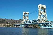
In the U.S. state of Michigan, US 41 is a state trunkline highway that enters the state via the Interstate Bridge between Marinette, Wisconsin and Menominee, Michigan. Along its 279.167-mile (449.276 km) route,[4] US 41 serves as a major conduit for Michigan traffic.[5] The route from the southern terminus to downtown Houghton is part of the National Highway System.[6] The trunkline comprises mostly two lanes, undivided except for sections that are concurrent with US 2 near Escanaba or M-28 near Marquette. US 41/M-28 is a four-lane expressway along the "Marquette Bypass", and segments of the highway in Delta and Marquette counties have four lanes.[7] and the Copper Country Trail National Scenic Byway. The trunkline ends at a cul-de-sac east of Fort Wilkins Historic State Park in Copper Harbor, serving the Central Upper Peninsula and Copper Country.[7][8]
Along the route, US 41 passes through farm fields, forest lands, and along the Lake Superior shoreline. The highway is included in the Lake Superior Circle Tour and the Lake Michigan Circle Tour.[7] It also passes through the Hiawatha National Forest and the Keweenaw National Historical Park.[9] Historical landmarks along the trunkline include the Marquette Branch Prison, Peshekee River Bridge, and the Quincy Mine.[10][11]
History
| |
|---|---|
| Location: | Naples–Miami |
| Existed: | 1926–1949 |
When their routes were originally laid out in 1926, US 41's southern endpoint was in Naples, Florida, at the western endpoint of US 94, which ran east to Miami. In 1949, US 94 was decommissioned, and the entire route became part of US 41, giving it an east–west section that retained the hidden SR 90 designation. The former US 94 ended in Miami at the same intersection where US 41 (and SR 90) do now. In 1953, US 41 was extended along US 1 and State Road A1A (SR A1A) to terminate in Miami Beach, Florida, but it was truncated back to the earlier terminus in 2000. Prior to 1993, when the Florida Department of Transportation color-coded U.S. highways in Florida, the color used for US 41 was orange.
US 41 initially took a more westerly route between Nashville, Tennessee, and Hopkinsville, Kentucky. The current US 41 was US 241. In 1930, the two routes became US 41W and US 41E, but in 1943 the western route became US 41 Alternate, with the main US 41 moving to the east route.
In July 2005, efforts started in Congress to re-designate US 41 between Milwaukee and Green Bay, Wisconsin, as I-41. The new Interstate would also include US 45 between current US 41 and the intersection with I-94 and I-894. It is believed that US 41 at that time would then be re-routed to remain concurrent with I-41.
Major intersections
- Florida
-
 US 1 in Miami
 -
 US 441 in Miami
 -
 US 17 in Punta Gorda
 -
 US 301 in Sarasota
 - US 301 in Bradenton. The highways travel concurrently to Palmetto.
-
 US 19 in Memphis
 -
 I‑275 north-northeast of Memphis
 -
 I‑4 in Tampa
 -
 US 92 in Tampa. The highways travel concurrently through the city.
 -
 US 98 in Brooksville. The highways travel concurrently through the city.
 -
 US 27 in Williston. The highways travel concurrently to High Springs.
 - US 441 in High Springs. The highways travel concurrently to south of Lake City.
-
 I‑75 in Ellisville
 -
 US 90 in Lake City
 -
 I‑10 northwest of Five Points
 -
 US 129 southeast of Jasper. The highways travel concurrently to Jasper.
 - Georgia
-

 US 84 / US 221 in Valdosta. US 41/US 221 travels concurrently through the city.
 - I‑75 northwest of Valdosta. The highways travel concurrently to Hahira.
-

 US 82 / US 319 in Tifton
 - I‑75 in Tifton
-
 US 280 in Cordele
 - I‑75 in Unadilla
- I‑75 in Perry
-
 US 341 in Perry
 - US 129 north of Sofkee. The highways travel concurrently to Macon.
- I‑75 in Macon
-
 US 80 in Macon
 -
 I‑475 in Bolingbroke
 - US 341 south of Barnesville
- US 19 south of Griffin. The highways travel concurrently to Atlanta.
- I‑75 west of Morrow
-
 I‑285 in Forest Park
 - I‑75 on the Atlanta–Hapeville city line
-
 I‑85 in Atlanta
 -
 US 29 in Atlanta. The highways travel concurrently through the city.
 -

 US 29 / US 78 / US 278 in Atlanta. US 41/US 78/US 278 travels concurrently through the city.
 - I‑75 in Atlanta
- I‑75 in Atlanta
- I‑75 in Atlanta
- I‑285 east of Smyrna
-
 US 411 in Cartersville. The highways travel concurrently to northwest of Cartersville.
 -
 US 76 east of Dalton. The highways travel concurrently to Chattanooga, Tennessee.
 - I‑75 in Dalton
- I‑75 southeast of Ringgold
- Tennessee
- I‑75 in East Ridge
-
 I‑24 in Chattanooga
 -

 US 11 / US 64 in Chattanooga. The highways travel concurrently through the city.
 - US 11 / US 64 in Chattanooga. US 11/US 41 travels concurrently through the city. US 41/US 64 travels concurrently to Jasper.
-
 US 27 / US 72 in Chattanooga. US 41/US 72 travels concurrently to Jasper.
 - I‑24 in Chattanooga
- I‑24 in Manchester
- I‑24 northwest of Manchester
-
 US 70S in Murfreesboro. The highways travel concurrently to Nashville.
 -
 US 231 in Murfreesboro. The highways travel concurrently through the city.
 -
 I‑24 / I‑40 in Nashville
 -
 US 31 in Nashville. The highways travel concurrently through the city.
 -

 US 70 / US 431 in Nashville. US 41/US 431 travels concurrently through the city.
 -

 US 31 / US 31E / US 31W in Nashville. US 31W/US 41 travels concurrently to Goodlettsville.
 -
 I‑65 in Nashville
 - US 431 in Springfield. The highways travel concurrently through the city.
- Kentucky
-
 US 79 in Guthrie
 -
 US 68 in Hopkinsville. The highways travel concurrently through the city.
 -
 US 62 in Nortonville
 -
.svg.png) Future I‑69 in Madisonville
Future I‑69 in Madisonville - Future I‑69 in Henderson. The highways travel concurrently through the city.
-
 Future I‑69 / US 60 in Henderson
 - Indiana
-
 I‑69 in Evansville
 -
 I‑64 on the Scott–Johnson township line
 -
 US 50 / US 150 in Vincennes. US 41/US 50 travels concurrently through the city. US 41/US 150 travels concurrently to Terre Haute.
 -

 I‑70 / US 40 in Terre Haute
 -
 US 36 in Rockville
 -
 US 136 in Veedersburg. The highways travel concurrently through the city.
 -
 I‑74 in Veedersburg
 -
 US 52 southeast of Earl Park. The highways travel concurrently to Kentland.
 -
 US 24 / US 52 in Kentland
 - US 231 in St. John
-
 US 30 in Schererville
 -


 I‑80 / I‑94 / US 6 in Hammond. The highways travel concurrently through the city.
 -
 I‑90 in Hammond
 -

 US 12 / US 20 in Hammond. The highways travel concurrently to Chicago.
 - I‑90 in Hammond
- Illinois
- I‑90 in Chicago
-
 I‑55 in Chicago
 -
 US 14 in Chicago
 - US 14 in Chicago
- I‑94 in Wilmette. The highways travel concurrently to Northbrook.
-
 I‑41 / I‑94 in Wadsworth. I-41/US 41 travels concurrently to Howard, Wisconsin. I-94/US 41 travels concurrently to Milwaukee, Wisconsin.
 - Wisconsin
-

 I‑43 / I‑894 in Milwaukee. I-43/US 41 travel concurrently through the city.
 -
 I‑43 / I‑794 in Milwaukee
 -
 US 18 in Milwaukee
 -
 US 45 in Milwaukee. The highways travel concurrently to Richfield.
 -
 US 151 in Fond du Lac
 - US 45 in Oshkosh
-
 US 10 northwest of Menasha
 -
 US 141 in Howard. The highways travel concurrently to the Town of Abrams.
 - I‑41 / I‑43 in Howard
- Michigan
-
 US 2 in Powers. The highways travel concurrently to Rapid River.
 - US 141 in Covington
- Cul-de-sac east of Fort Wilkins Historic State Park east of Copper Harbor
See also
References
- 1 2 Droz, Robert V. "The Big Table". U.S. Highways : From US 1 to (US 830). Retrieved February 20, 2006..
- ↑ Designated Roads of Florida. Florida Dept. of Transportation. http://www.dot.state.fl.us/planning/statistics/hwydata/desroads.pdf
- ↑ Estimated distance via Rand McNally (2004). The Road Atlas (Map) (2004 ed.). Chicago: Rand McNally.
- ↑ Michigan Department of Transportation & Michigan Center for Shared Solutions and Technology Partnerships (2009). MDOT Physical Reference Finder Application (Map). Michigan Department of Transportation. Retrieved January 25, 2008.
- ↑ Michigan Department of Transportation (April 28, 2004). "Chapter One" (PDF). US 41/M-28 Access Management Plan. Michigan Department of Transportation. Archived from the original (PDF) on December 23, 2007. Retrieved January 18, 2008.
- ↑ Michigan Department of Transportation (April 23, 2006). National Highway System, Michigan (PDF) (Map). Lansing: Michigan Department of Transportation. Retrieved February 4, 2008.
- 1 2 3 Michigan Department of Transportation (2007). Michigan: Official Department of Transportation Map (Map). c. 1:975,000. Lansing: Michigan Department of Transportation. §§ A4–F5. OCLC 42778335.
- ↑ Google (August 29, 2008). "Copper Harbor, Grant, MI" (Map). Google Maps. Google. Retrieved August 29, 2008.
- ↑ Rand McNally. "Michigan" (Map). The Road Atlas (2008 ed.). 1 in:20 mi. Chicago: Rand McNally. p. 50. §§ A13–B14, D1–I3. ISBN 0-528-93981-5.
- ↑ "National Register of Historic Places: Michigan (MI), Marquette County". National Register of Historic Places. 1999. Retrieved February 12, 2008.
- ↑ "National Register of Historic Places: Michigan (MI), Houghton County". National Register of Historic Places. 1999. Retrieved September 3, 2008.
- Endpoints of U.S. highways: U.S. Highway 41 and U.S. Highway 94
External links
| Wikimedia Commons has media related to U.S. Route 41. |
- Illinois Highway Ends: US 41
- Michigan Highway Ends: US 41
- US 41 entry at Michigan Highways
- Wisconsin Highways - US-41: The Complete History
| Browse numbered routes | ||||
|---|---|---|---|---|
| ← | GA | SR 41 | ||
| ← | KY | US 42 | ||
Routes in italics are no longer a part of the system. Highlighted routes are considered main routes of the system. |