U.S. Route 411
| |
|---|---|
 | |
| Route information | |
| Auxiliary route of US 11 | |
| Length: | 314 mi (505 km) |
| Existed: | 1934 – present |
| Major junctions | |
| South end: |
|
| |
| North end: |
|
| Location | |
| States: | Alabama, Georgia, Tennessee |
| Highway system | |

U.S. Route 411 (US 411) is an alternate parallel-highway associated with US 11. US 411 extends for about 313 miles (504 km) from US 78 in Leeds, Alabama, to US 25 in Newport, Tennessee. US 411 passes through northeastern Alabama, northwestern Georgia, and southeastern Tennessee. Notable towns and cities along its route include Gadsden, Alabama; Rome, Georgia; Cartersville, Georgia; Cleveland, Tennessee; Maryville, Tennessee; Sevierville, Tennessee, and Newport, Tennessee.
US 411 and US 11 never intersect with one another, though they come very close in Birmingham, Alabama, Gadsden, Alabama, Cleveland, Tennessee, and Maryville, Tennessee. US 411 also spends much of its route close to the Interstate Highway System: Interstate 40 (I-40), I-75, and I-59, though it never intersects I-59.
Route description
Most of the distance through which US 411 passes is rural countryside, with no major metropolitan areas directly along its route. However, it does pass relatively near the major cities of Birmingham, Alabama, Chattanooga, Tennessee, and Knoxville, Tennessee. In Sevier County, Tennessee, south of Knoxville, US 411 is used by many tourists as a route to the northern side of the Great Smoky Mountains National Park. US 411 passes about 20 miles (32 km) north of the national park, but it intersects with US 441, which actually goes through this park. Although US 411 has a south–north designation, it contains long stretches that are west–east, and its overall direction is actually southwest–northeast.
US 411 is generally a two-lane highway through the countryside. However, it has long been a four-lane, divided highway connecting Rome and Cartersville, Georgia, and it is a multi-lane highway connecting Cartersville with I-75. Also, for part of its route in the Cartersville area, US 411 shares a four-lane, divided highway with US 41. Furthermore, the Tennessee Department of Transportation is in the process of widening of this highway to four lanes between Maryville and Benton, Tennessee, with the two stretches from Maryville to Madisonville, Tennessee, and Englewood to Delano, Tennessee, completed.
Alabama
US-411 begins at US-78 (Parkway Drive) in the city of Leeds in far eastern Jefferson County. SR-25, the U.S. Highway's companion route, continues south as a signed highway that briefly follows US 78 east before splitting south toward Harpersville. US-411 heads north along two-lane 9th Street, which has a pair of at-grade crossings of Norfolk Southern Railway rail lines. The street's name changes to Whitmire Street, which the U.S. Highway follows to Ashville Road. US-411 follows Ashville Road, a two-lane road with center turn lane, northeast into St. Clair County, where the highway expands to four lanes. The U.S. Highway meets I-20 at a partial cloverleaf interchange as it leaves the city of Leeds. US-411 continues as two-lane Moody Parkway northeast through the Cahaba Valley formed by the Little Cahaba River between Pine Ridge to the west and Oak Ridge to the east. The highway has a brief concurrency with SR-174 through Odenville, where the highways pass under a CSX rail line.
US-411 continues northeast through the Beaver Creek Valley between Pine Ridge and the Beaver Creek Mountains. The highway leaves the valley after it joins US-231 (Heart of Dixie Highway) to pass through Pine Ridge to the city of Ashville. The U.S. Highways enter town along 5th Street and proceed to the county courthouse, where they meet the eastern end of SR-23 (6th Avenue). Both highways turn east onto 6th Avenue, then US-231 turns north onto Court Street East. US-411 leaves Ashville along Rainbow Drive, which heads northeast between Big Canoe Creek and Canoe Creek Mountain to the south. The U.S. Highway crosses the mountain and enters Etowah County where it crosses the Big Canoe Creek branch of Neely Henry Lake. US-411 follows the western flank of Dunaway mountain to Rainbow City, where the route intersects SR-77 (Grand Avenue).
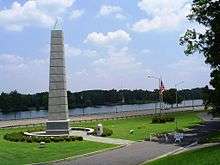
US-411 expands to a four-lane divided highway as it enters the city of Gadsden. The highway crosses the Big Wills Creek branch of Neely Henry Lake and meets the eastern end of I-759 at a partial cloverleaf interchange; that freeway continues east as SR-759. US-411 veers onto Albert Rains Boulevard, which follows the right bank of the Coosa River through downtown Gadsden. The highway passes by the Spirit of American Citizenship Monument and under Broad Street, a CSX rail line, and US-278 and US-431 (Meighan Boulevard), which access US-411 via a partial cloverleaf interchange. US-411 leaves (or will soon exit) Gadsden along a newly constructed four-lane divided highway that passes between Shinbone Ridge to the west and several loops of the Coosa River. The U.S. Highway drops to two lanes before it enters Cherokee County, then expands again to a four-lane divided highway, Weiss Lake Boulevard.
US-411 curves east along the northern edge of Weiss Lake and intersects SR-68 (Industrial Boulevard) in the town of Leesburg, east of which US-411 and SR-68 cross the lake, an impoundment of the Coosa River. Shortly after entering the city of Centre, the U.S. Highway and state highway turn onto the Clarence E. Chestnut Jr. Bypass, a four-lane road with center turn lane; US-411 Business and SR-25 continue along Main Street into the center of town. SR-68 diverges from the U.S. Highway at Cedar Bluff Road, which carries SR-283 southwest toward downtown. SR-283 becomes US-411's companion route on the bypass, which next intersects SR-9 (Armory Road), which intersects SR-68 immediately to the north. US-411 drops to two lanes east of SR-9 and curves south to collect the east end of US-411 Business (Main Street) and SR-25 on the eastern edge of Centre. US-411 continues east and crosses Cowan Creek before reaching the Alabama–Georgia state line and the northern terminus of SR-25 east of the hamlet of Forney.
Georgia
US 411 enters Georgia at the western terminus of its companion SR 53 in the southwestern corner of Floyd County. The two-lane highway, which is named Gadsden Road, has a brief concurrency with SR 100, which heads north as Fosters Mill Road and south as Mill Street, on the west side of the town of Cave Spring. US 411 enters town along Alabama Street and leaves to the northeast along Rome Street. The U.S. Highway continues as Cave Spring Road, which crosses Cedar Creek and passes through Vans Valley. US 411 passes under the West Rome Bypass and intersects US 27 and SR 1 (Cedartown Highway), which US 411 joins heading north. The four-lane road with center turn lane passes along the west side of Lindale and between Walker Mountain and Booze Mountain on the west and east, respectively.
US 411 and US 27 expand to a divided highway as they enter the city of Rome and then a four-lane freeway as they cross over a Norfolk Southern rail line. The freeway has a diamond interchange with Darlington Drive and Old Lindale Road and a half-diamond interchange with Maple Road. Immediately to the east of the second interchange, US 411 passes through a directional T interchange; US 27, SR 1, SR 20, and SR 53 head north toward downtown Rome and US 411 and SR 20 head east. Immediately to the east of the split, the U.S. Highway has a partial cloverleaf interchange with SR 101 (Dean Avenue); there is no ramp from SR 101 to westbound US 411. The freeway ends east of SR 101. US 411 has an intersection with the southern end of SR 1 Loop (East Rome Bypass) before leaving the city limits.
US 411 heads east along Cartersville Highway into Bartow County. The four-lane divided highway parallels and then crosses the Etowah River. US 411 crosses over an east–west CSX rail line immediately before its trumpet interchange with US 41 and SR 3 (Joe Frank Harris Parkway). The two U.S. Highways head southeast into the city of Cartersville then diverge immediately to the east of a north–south CSX rail line at the boulevard's partial cloverleaf interchange with SR 61 (Tennessee Street). Immediately to the north of the interchange, SR 20 (Canton Highway) splits east and SR 61 becomes US 411's companion highway toward Tennessee. The U.S. Highway heads north as a four-lane undivided highway that becomes divided temporarily through the highway's partial cloverleaf interchange with I-75 (Larry McDonald Memorial Highway).
US 411 drops to two lanes south of the town of White, where the highway begins to closely parallel the north–south CSX rail line. The U.S. Highway intersects SR 140 (Henry Mack Hill Road) in the hamlet of Rydal before entering Gordon County. US 411 passes through the town of Fairmount as Salacoa Street; the U.S. Highway runs concurrently with SR 53 between Calhoun Street and Fairmount Highway. North of the town of Ranger, through which the route is named Tennessee Highway, the highway meets the eastern end of SR 156 (Red Bud Road). US 411 passes through the town of Oakman, then diverges from a road called Old Highway 411, crosses to the west side of the railroad, intersects SR 156 (Nicklesville Road), and enters Murray County. The U.S. Highway passes to the west of Reregulation Reservoir and Carters Lake, both impoundments of the Coosawattee River, which the highway crosses to the west of the lakes.
US 411 intersects US 76 and SR 282, which follow part of Old Highway 411 before heading east through the Cohutta Mountains, and the U.S. Highways begin to run concurrently as a four-lane undivided highway along the west flank of Fort Mountain. US 411 and US 76 continue as 3rd Avenue through the city of Chatsworth. In the center of town, the highways intersect Fort Street, which carries SR 2 and SR 52 east toward Fort Mountain and State Route 52 Alternate to the west. At the north end of town, US 76 and SR 52 leave US 411 along G.I. Maddox Boulevard. The U.S. Highway passes along the west flank of Camp Ground Mountain and is named Hill Street through the town of Eton, where the route meets the eastern end of SR 286 (Coffey Road) and drops to two lanes. US 411 passes through the town of Crandall, crosses to the east side of the railroad, and follows the Fairy Valley to the hamlet of Cisco, where SR 2 splits to the west. US 411 crosses over to the west side of the rail line in the hamlet of Tennga immediately before reaching the Georgia–Tennessee state line, where SR 61 has its northern terminus.
Tennessee

US-411 enters Tennessee at the southern terminus of its companion SR-33 in the southwestern corner of Polk County. The highway crosses the Conasauga River in the hamlet of Conasauga and meets the eastern end of SR-313 (Ladd Springs Road) in Oldfort. US-411 parallels the Norfolk Southern rail line through the hamlet of Ocoee, where the highway expands to four lanes plus a center turn lane and has a partial cloverleaf interchange with US 64 and US 74. North of Ocoee, US-411 crosses over the railroad and the Ocoee River and passes through the town of Benton, where the route meets the northern end of SR-314 (Parksville Road). The U.S. Highway expands to a divided highway north of the town. US-411 intersects and begins to run concurrently with SR-30, crosses the Hiwassee River, and meets the eastern end of SR-163 in the village of Delano.
US-411 becomes undivided and crosses over the Norfolk Southern rail line shortly after entering McMinn County. In the town of Etowah, the highway follows Tennessee Avenue, meets the western end of SR-310 (Mecca Pike), and SR-30 splits west along David M. Lilliard Memorial Highway.
Major intersections
Alabama
| County | Location | mi [1] | km | Destinations | Notes |
|---|---|---|---|---|---|
| Jefferson | Leeds | 0.000 | 0.000 | Southern terminus of US-411; south end of concurrency with SR-25; SR-25 continues as a signed highway south of US-411 | |
| St. Clair | 2.118 | 3.409 | I-20 Exit 144 | ||
| Odenville | 12.428 | 20.001 | South end of concurrency with SR-174 | ||
| 13.430 | 21.613 | North end of concurrency with SR-174 | |||
| | 23.113 | 37.197 | South end of concurrency with US-231 | ||
| Ashville | 27.211 | 43.792 | Northern terminus of SR-23 | ||
| 27.235 | 43.830 | North end of concurrency with US-231 | |||
| Etowah | Rainbow City | 43.215 | 69.548 | ||
| Gadsden | 46.767 | 75.264 | I-759 Exit 4; Eastern terminus of I-759; Western terminus of SR-759 | ||
| 48.306 | 77.741 | Partial cloverleaf interchange | |||
| Cherokee | Leesburg | 66.460 | 106.957 | South end of concurrency with SR-68 | |
| Centre | 69.780 | 112.300 | North end of concurrency with SR-25 | ||
| 71.994 | 115.863 | North end of concurrency with SR-68; south end of concurrency with SR-283 | |||
| 72.143 | 116.103 | ||||
| 74.353 | 119.660 | Northern terminus of SR-283; south end of concurrency with SR-25 | |||
| Forney | 88.397 | 142.261 | Northern terminus of US-411 in Alabama; northern terminus of SR-25; Georgia state line | ||
1.000 mi = 1.609 km; 1.000 km = 0.621 mi
| |||||
Georgia
| County | Location | mi | km | Destinations | Notes |
|---|---|---|---|---|---|
| Floyd | Haney | Southern terminus of US 411 in Georgia; western terminus of SR 53; Alabama state line | |||
| Cave Spring | South end of concurrency with SR 100 | ||||
| North end of concurrency with SR 100 | |||||
| Six Mile | South end of concurrency with US 27 and SR 1 | ||||
| Rome | Darlington Drive / Old Lindale Road | interchange | |||
| Maple Road | interchange; southbound exit and northbound entrance | ||||
| interchange; north end of concurrencies with US 27 and SR 1 and SR 53; south end of concurrency with SR 20 | |||||
| interchange; no southbound entrance | |||||
| Bartow | | interchange; south end of concurrency with US 41 and SR 3 | |||
| Cartersville | interchange; north end of concurrency with US 41 and SR 3; south end of concurrency with SR 61 | ||||
| North end of concurrency with SR 20 | |||||
| I-75 exit 293 | |||||
| Rydal | |||||
| Gordon | Fairmount | South end of concurrency with SR 53 | |||
| North end of concurrency with SR 53 | |||||
| | |||||
| | |||||
| Murray | Ramhurst | South end of concurrency with US 76 | |||
| Chatsworth | South end of concurrency with SR 2 and SR 52 | ||||
| North end of concurrencies with US 76 and SR 52 | |||||
| Eton | |||||
| Cisco | North end of concurrency with SR 2 | ||||
| Tennga | Northern terminus of US 411 in Georgia; northern terminus of SR 61; Tennessee state line | ||||
1.000 mi = 1.609 km; 1.000 km = 0.621 mi
| |||||
Tennessee
| County | Location | mi | km | Destinations | Notes |
|---|---|---|---|---|---|
| Polk | Conasauga | Southern terminus of US 411 in Tennessee; southern terminus of SR-33; Georgia state line | |||
| Oldfort | |||||
| Ocoee | Partial cloverleaf interchange | ||||
| Benton | |||||
| | South end of concurrency with SR-30 | ||||
| Delano | |||||
| McMinn | Etowah | ||||
| North end of concurrency with SR-30 | |||||
| Englewood | South end of concurrency with SR-39 | ||||
| North end of concurrency with SR-39 | |||||
| Monroe | Madisonville | Partial cloverleaf interchange | |||
| Warren Street south – Madisonville | Southbound exit, northbound entrance | ||||
| Vonore | South end of concurrency with SR-72 | ||||
| North end of concurrency with SR-72 | |||||
| Loudon | | ||||
| Blount | | ||||
| | South end of concurrency with US-129 | ||||
| Maryville | |||||
| Directional T interchange; no access from southbound US-129 to northbound US-411; north end of concurrency with US-129 | |||||
| North end of concurrency with SR-33; south end of concurrency with SR-35 | |||||
| Sevier | Seymour | South end of concurrency with US-441 | |||
| Sevierville | North end of concurrency with US-441 | ||||
| Jefferson | Chestnut Hill | ||||
| Cocke | Newport | Northern end of US 25/US 70 concurrency | |||
| Northern terminus of US-411; SR-35 continues as an unsigned highway north of US-411; I-40 exits 432 A-B | |||||
1.000 mi = 1.609 km; 1.000 km = 0.621 mi
| |||||
See also
 Alabama portal
.svg.png) Georgia (U.S. state) portal
Georgia (U.S. state) portal Tennessee portal
 U.S. Roads portal
References
<div class="reflist columns references-column-width" style="-moz-column-width: 30em
[1]; -webkit-column-width: 30em
[1]; column-width: 30em
[1]; list-style-type: decimal;">
- 1 2 3 4 Alabama Department of Transportation. "Milepost Maps". Retrieved 2013-10-29.
- Jefferson County (PDF)
- St. Clair County (PDF)
- Etowah County (PDF)
- Cherokee County (PDF)
| Wikimedia Commons has media related to U.S. Route 411. |
| Browse numbered routes | ||||
|---|---|---|---|---|
| ← | TN | US 412 | ||