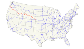
U.S. Route 26
| |
|---|---|
 | |
| Route information | |
| Length: | 1,485 mi[1] (2,390 km) |
| Existed: | 1926[1] – present |
| Major junctions | |
| West end: |
|
|
| |
| East end: |
|
| Location | |
| States: | Oregon, Idaho, Wyoming, Nebraska |
| Highway system | |

U.S. Route 26 is an east–west United States highway. It started in Ogallala, Nebraska, and gradually grew to reach the West Coast in Oregon. When the U.S. highway system was first defined, it was limited to Nebraska and Wyoming; by the 1950s, it continued into Idaho and Oregon. The highway's eastern terminus is in Ogallala, Nebraska at an intersection with Interstate 80. Its western terminus is south of Seaside, Oregon at an intersection with U.S. Route 101. Prior to 2004, the route's last 20 miles (32 km) were co-signed with U.S. Route 101 from the highways' junction south of Seaside north to Astoria where its intersection with U.S. Route 30 was also U.S. 30's western terminus.[2]
Much of the highway follows the path of the historic Oregon Trail. At its peak, immediately before the establishment of the interstate highway system, US 26 was 1,557 miles (2506 km) in length, and terminated in Astoria, Oregon.
Route description
Oregon
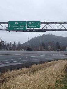
Starting at a junction with U.S. Highway 101 near Seaside, Oregon, U.S. Highway 26 heads southeast through the Coast Range to Portland. In the western Portland area, US 26 is a freeway known as the Sunset Highway. After passing through the Vista Ridge Tunnel, heading into downtown Portland, it intersects with Interstate 405 and runs along the interstate southbound for about a half-mile before exiting onto surface streets at the waterfront, meeting Oregon Route 43 at Macadam Avenue before crossing Interstate 5. After crossing the Willamette River and meeting at an incomplete interchange with Oregon Route 99E, US26 then heads east on Powell Boulevard where it crosses Interstate 205 and continues east to Sandy on what is known as the Mount Hood Highway No. 26 (see Oregon Routes and Highways), a four-lane divided highway that was supposed to be the Mount Hood Freeway, which was never built just south of Division St.
After passing through Sandy, Highway 26 (known there as the Mount Hood Highway) continues on towards Government Camp and Bennett Pass, where it eventually meets up with Oregon Route 35. The Mount Hood Highway continues north along Oregon Route 35, while Highway 26 heads southeast towards Madras, where it intersects with U.S. Route 97. It then continues southeast to Prineville, where it meets Oregon Route 126 and heads east through John Day where it meets U.S. Route 20 in Vale. The remainder of Highway 26 follows U.S. Route 20 to the Idaho state line.
Idaho
From the Oregon state line, U.S. 26 continues to follow U.S. 20 to Boise, with short multiplexes with U.S. Highway 95 near Parma and Interstate 84 at Caldwell. At Boise, U.S. 26/U.S. 20 merges with I-84 for about 40 miles until Mountain Home, where U.S. 20 splits from U.S. 26/I-84. About 41 miles later in Bliss, U.S. 26 splits from I-84 for 66 miles until again joining U.S. 20 at Carey, skirting the north edge of Craters of the Moon National Monument. Near Idaho National Engineering Laboratory, U.S. 26 again splits from U.S. 20 to the southeast, proceeding to Blackfoot, where U.S. 26 joins Interstate 15 for about 20 miles before splitting just south of Idaho Falls toward Alpine, Wyoming.
Wyoming
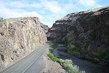
From Alpine, US 26 is co-signed with U.S. Route 89 east and north to Hoback Junction, then co-signed with US 89, U.S. Route 189, and U.S. Route 191 to Jackson. US 189 ends in Jackson, and the other three highways continue their concurrency through Grand Teton National Park up to Moran. At "Glacier View Turnout," a view of Teton Glacier, on the north of Grand Teton, can be seen.[3] At Moran, US 26 turns east, concurrent with U.S. Route 287. Crossing the Continental Divide at Togwotee Pass, US 26 passes through Dubois, Wyoming, the end of the Wyoming Centennial Scenic Byway, and at Diversion Dam Junction, US 26 and US 287 separate; US 26 continues southeast to Riverton, then northeast to Shoshoni. From Shoshoni to Casper, US 26 is co-signed with U.S. Highway 20. US 20-26 has a bypass north of Casper, the eastern half of which is concurrent with Interstate 25 and U.S. Route 87. US 20-26-87 parallels I-25 from Casper to Glenrock; east of Glenrock, US 26 (along with US 20 and US 87) is co-signed on I-25. US 26 follows I-25 to Dwyer Junction, where it turns east to continue along the Old Oregon Trail. US 26 passes through Guernsey, Fort Laramie, Lingle, and Torrington before entering Nebraska. U.S. Route 85 is concurrent with US 26 between Lingle and Torrington.[4]
Nebraska
US 26 runs southeastward parallel to the North Platte River. The largest city US 26 runs through in Nebraska is Scottsbluff, which is just 22 miles (35 km) from the Wyoming border. US 26 also goes past the Chimney Rock National Historic Site. US 26 intersects with U.S. Highway 385 in Bridgeport and then continues to its eastern terminus in Ogallala, Nebraska at Interstate 80. All told, there are 145 miles (233 km) of US 26 in the state of Nebraska.
History
U.S. Highway 320 (US 320) was part of the initial 1926 system, connecting US 20 in Shoshoni with US 87W in Riverton, Wyoming. It became WYO 320 in 1938, which was extended southwest to Lander in 1940 when US 287 (which had replaced US 87W) was realigned. The original part of US 320/WYO 320 became part of an extension of US 26 in 1950, and the rest of WYO 320 became part of WYO 789 in 1954.[5]
Major intersections
- Oregon
-
 US 101 south of Seaside
 -
 I‑405 in Portland. The highways travel concurrently through the city.
 -
 I‑205 in Portland
 -
 US 97 in Madras. The highways travel concurrently through the city.
 -
 US 395 in Mount Vernon. The highways travel concurrently to John Day.
 -
 US 20 in Vale. The highways travel concurrently to Mountain Home.
 - Idaho
-
 US 95 north-northwest of Parma. The highways travel concurrently to southeast of Parma.
 -

 I‑84 / US 30 north of Caldwell. The highways travel concurrently to Caldwell.
 -
 I‑184 in Boise. The highways travel concurrently through the city.
 - I‑84 / US 30 in Boise. I-84/US 26 travel concurrently to Bliss. US 26/US 30 travel concurrently to west-northwest of Bliss.
-
 US 93 in Shoshone. The highways travel concurrently to Arco.
 - US 20 in Carey. The highways travel concurrently to northwest of Atomic City.
-
 I‑15 in Blackfoot. The highways travel concurrently to Idaho Falls.
 -
 US 91 in Idaho Falls
 - Wyoming
-
 US 89 on the Alpine Northwest–Alpine Northeast line. The highways travel concurrently to Moran.
 -

 US 189 / US 191 in Hoback Junction. US 26/US 189 travel concurrently to Jackson. US 26/US 191 travel concurrently to Moran.
 -
 US 287 in Moran. The highways travel concurrently to west-northwest of Morton.
 - US 20 in Shoshoni. The highways travel concurrently to Orin.
-
 I‑25 / US 87 on the Casper–Hartrandt city line. I-25/US 26 travel concurrently into Casper proper. US 26/US 87 travel concurrently to west-southwest of Dwyer.
 - I‑25 southeast of Glenrock. The highways travel concurrently to west-southwest of Dwyer.
-
 US 18 in Orin
 -
 US 85 in Lingle. The highways travel concurrently to Torrington.
 - Nebraska
-
 US 385 in Bridgeport. The highways travel concurrently to Northport.
 - US 30 west of Ogallala. The highways travel concurrently to Ogallala.
-
 I‑80 in Ogallala. The roadway continues as
  N-61.
N-61.
See also
References
| Wikimedia Commons has media related to U.S. Route 26. |
- 1 2 US Highways from US 1 to US 830 Robert V. Droz
- ↑ "Endpoints of US highways". Retrieved 9 October 2014.
- ↑ Grand Teton National Park Photographer's Map & Guide. Earthwalk Press. 2008. ISBN 978-0-915749-25-6.
- ↑ "Wyoming @ AARoads - U.S. Highway 26". Retrieved 9 October 2014.
- ↑ Wyoming @ AARoads.com - U.S. Highway 320 (Decommissioned)
Routes in italics are no longer a part of the system. Highlighted routes are considered main routes of the system. |
| Browse numbered routes | ||||
|---|---|---|---|---|
| ← | NE | N-27 | ||
| ← | WY | WYO 26 | ||