Tugby and Keythorpe
| Tugby | |
 Hallaton Road, Tugby |
|
 Tugby |
|
| Population | 330 (2011 Census) |
|---|---|
| OS grid reference | SK768011 |
| Civil parish | Tugby and Keythorpe |
| District | Harborough |
| Shire county | Leicestershire |
| Region | East Midlands |
| Country | England |
| Sovereign state | United Kingdom |
| Post town | LEICESTER |
| Postcode district | LE7 |
| Police | Leicestershire |
| Fire | Leicestershire |
| Ambulance | East Midlands |
| EU Parliament | East Midlands |
|
|
Coordinates: 52°36′11″N 0°52′00″W / 52.60315°N 0.86672°W
Tugby and Keythorpe is a parish comprising the village of Tugby and land surrounding Keythorpe Grange, Keythorpe Hall, Hall Farm and Lodge Farm in Leicestershire, England, part of Harborough District. The Parish covers around 2,200 acres, situated 7 miles west of Uppingham, and 12 miles south of Leicester.[1] According to the 2011 census the population of the parish was 330.[2] The Anglican parish register for the parish dates back to 1568.[3] The boundaries of the parish has not changed throughout the years, meaning that the parish's size remains the same as it did in 1568.[3]
In the 1887 Gazetter of the British Isles it is suggested that the town dates back to Norman rule stating:
"The church has a Norman tower, and is good."[4]

Demographics
Population Overview
Over the years population has been an ever changing demographic, with there being distinct peaks and peaks and troughs.[5]

In the 1801 census population sat at 230 people, which then grew, reaching the parishes peak population of 365 people in 1851.[5] This figure rapidly declined after reaching a record low population of 220 in 1961.[5] This figure then began to increase overtime, seeing the population of the parish grow to 330 in 2011.[6] According to the 2011 census data, around 31% of the population was aged 35 to 54, and only 9% of the population aged 16–24.[7] 98% of the population were White British, with only 4 people in the parish identifying as another ethnic group.[8] However, 10 people were born outside of the UK.[8] 72% of the parishes population identify as Christian, 26% identify as having no religion, or religion not stated, with only 0.9% identifying as part of an another religious community.[9]
Occupation
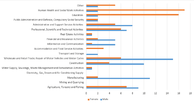
When studying the occupational fields of the 1881 census you can see a clear difference between the jobs of men and women. Many of the women’s occupations, 59.63% of the overall female population, at the time was unknown, which would suggest that they were unemployed, most likely staying at home.[10] Out of the women in employment the most common occupation type is domestic services, at 16.91% of the female population, likely due to the presence of Keythorpe manor.[10] The men at the time tended to peruse more manual labor based jobs, mainly agriculture based, with 61.36% of the total male population working in agriculture.[10]
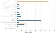
When looking at 2011 census data you can see that the divide between male and female employment has reduced, with only 4 women in the village not having a specific occupation.[11] The most popular occupation for women to have in the village is human health and social work activities, at around 21.8%, and education at around 20.5% of the overall female population of the village.[11] As for the males the type of work has really diversified quite significantly, with a drop in agricultural work, only 9 men working in this sector unlike in 1881, where 52 worked in this sector.[12] Although the majority of the male population work in wholesale and retail trade (18.3% of the population), there has been an increase in other occupations.[13]
Health
Overall health in the village is good with the results of the 2011 census data showing that 46.6% of Tugby’s population were in 'Very Good Health'.[14] No one was in very bad health, with only 1.5% of the population in bad health.[14] 87.9% of the population stated that their health did not limit their daily life.[14]
Housing
The typical housing types in Tugby and Keythorpe are terraced, flats, semi-detached, and detached.[15] House prices value, some being of low value whist others area very high. There is also a range of owner-occupied, social housing, and private rental homes, to match the needs of the community, with a NRS social grade of ABC1C2D.[15]
Notable Places
Church of St Thomas Becket
Tugby and Keythorpe is home to 9 Grade II listed buildings,[13] one of which being Church of St Thomas Becket, the Parish's church,[16] dedicated to St Thomas Becket. It is able to seat 300.[1] The St Thomas Beckett parish church was awarded £10,700 by the Heritage Lottery Fund (HLF) to invest in a project to help protect and conserve the church’s tower.[17] This work is planned take place over two years, hoping to prevent the deterioration of the tower which can be dated to Anglo Saxon, and Norman construction.[17]
Tugby C of E Primary school
Tugby C of E primary school, situated on Main Street,[18] is the parish's only primary school. It has a very large catchment area in order to provide for the local rural community, including the villages Tilton on the Hill, and Skeffington.[19]
Keythorpe Valley Farm
Keythorpe Valley farm is a farm in the parish that specializes in breading traditional rare breed British pigs such as the Gloucester Old Spot, British Saddleback, and Large Black, along with cattle, sheep and goats, of which their produce is sold in the farm shop.[20]
Keythorpe Hall/Manor
Keythorpe Hall and Keythorpe 'Manor' are two completely separate properties a little distance apart. Keythorpe 'Manor' now a wedding venue is based on the A47 and was originally called Keythorpe Grange, but was renamed when it became a wedding venue. Keythorpe Hall has always been called such but apparently was relocated stone by stone to a more prominent position many years ago.
Keythorpe Hall was owned by members of the Berners Barony, specifically Sir Raymond Robert Tyrwhitt-Wilson, as of 1912.[1] In more recent years its name was changed to Keythorpe Grange and sold in 2011 for £1,837,500.[21]
References
- 1 2 3 GENUKI. "Genuki: Tugby, Leicestershire". www.genuki.org.uk. Retrieved 2016-04-24.
- ↑ "" Tugby and Keythorpe (Parish): Key Figures for 2011 Census: Key Statistics". Neighbourhood Statistics. Office for National Statistics. Retrieved 15 March 2016.
- 1 2 "Tugby". Genuki. Retrieved 15 March 2016.
- ↑ Bartholomew, John (1887). Gazetteer Of the British Isles (1st ed.). Edinburgh: Bartholomew.
- 1 2 3 "Tugby's population changes 1801-1961". Vision of Britain. GB Historical GIS / University of Portsmouth. Retrieved 21 March 2016.
- ↑ "Tugby 2011 census data". Neighbourhood statistics. Office for National Statistics. Retrieved 21 March 2016.
- ↑ "Tugby 2011 census data: Adult Lifestage". Neighbourhood Statistics. Office for National Statistics. Retrieved 22 April 2016.
- 1 2 "Tugby 2011 census data:Ethnic Group". Neighbourhood Statistics. Office for National Statistics. Retrieved 22 April 2016.
- ↑ "Tugby 2011 census data: Religion". Neighbourhood Statistics. Office for National Statistics. Retrieved 22 April 2016.
- 1 2 3 "Tugby's employment data 1881". Vision of Britain. GB Historical GIS / University of Portsmouth. Retrieved 24 April 2016.
- 1 2 "Tugby 2011 census data: Industry Female". Neighbourhood statistics. Office for National Statistics. Retrieved 21 March 2016.
- ↑ "Tugby 2011 census data: Industry Male". Neighbourhood statistics. Office for National Statistics. Retrieved 21 March 2016.
- 1 2 "Listed Buildings in Tugby and Keythorpe". British listed buildings. Retrieved 15 March 2016.
- 1 2 3 "Tugby 2011 census data: Health and Provision of Unpaid Care". Neighbourhood statistics. Office for National Statistics. Retrieved 21 March 2016.
- 1 2 Services, Good Stuff IT. "Main Street, Tugby and Keythorpe, Tugby, Leicestershire Map and local information - the British Streets website". British Streets. Retrieved 2016-04-24.
- ↑ "Parish Finder". A church near you. Retrieved 15 March 2016.
- 1 2 "Funding award will save Tugby Church tower". Diocese of Leicester. 27 October 2015. Retrieved 15 March 2016.
- ↑ "Tugby CofE School". Tugby CofE School. Retrieved 21 March 2016.
- ↑ "Appendix 1 Tugby Catchment Document". Tugby CofE. Retrieved 21 March 2016.
- ↑ "Keythorpe Farm Info". Keythorpe Farm. Retrieved 21 March 2016.
- ↑ "Keythorpe grange sale". www.rightmove.co.uk. Retrieved 2016-04-24.
External links
![]() Media related to Tugby and Keythorpe at Wikimedia Commons
Media related to Tugby and Keythorpe at Wikimedia Commons