Tso Lhamo Lake
| Tso Lhamo Lake | |
|---|---|
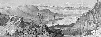 Tibet and Tso Lhamo Lake from the summit of the Donkia Pass, looking northwest as reported in Joseph Dalton Hooker's Himalayan Journals. | |
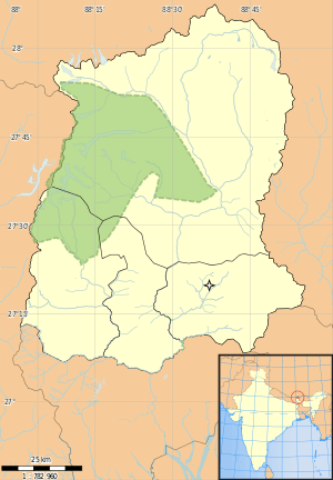 Tso Lhamo Lake Location in Sikkim | |
| Location | North Sikkim, Sikkim, India |
| Coordinates | 28°00′33″N 88°45′19″E / 28.0091°N 88.7553°ECoordinates: 28°00′33″N 88°45′19″E / 28.0091°N 88.7553°E |
| Primary inflows | Glacial |
| Basin countries | India |
| Designation | Restricted area |
| Max. depth | 5.5 m (18 ft) |
| Surface elevation | 5,330 m (17,490 ft) |
Tso Lhamo lake[1] or Chho Lhamo[2] or Cholamu lake [3] or Cholamoo lake[4][5] is one of the highest lakes in the world, located at an altitude of 5,330 m (17,490 ft).[6] It is situated in North Sikkim, India, only some 4 kilometres (2.5 mi) southwest of the Chinese border.
Geography
This glacial, fresh-water lake[7] is located northeast of the Kangchenjunga range in a high plateau area connected with the Tibetan Plateau.[1]
The Gurudongmar Lake lies some 5 km (3.1 mi) to the west.
See also
| Wikimedia Commons has media related to Tso Lhamo Lake. |
References
- 1 2 Negi, S.S. (1 April 2002). Himalayan Rivers, Lakes and Glaciers. New Delhi, India: Indus Publishing Company. p. 156. ISBN 978-81-85182-61-2. Retrieved 2009-11-27.
- ↑ Das, Sujoy; Roy, Anuradha (2 January 2002). Sikkim : A Traveller's Guide. New Delhi, India: Sangam Books Ltd. p. 38. ISBN 978-81-7824-008-4. Retrieved 2009-11-27.
- ↑ Bisht, Ramesh Chandra (1 January 2008). International Encyclopaedia of Himalayas (5 Vols.). New Delhi, India: Mittal Publication. p. 18. ASIN B002QVXS82. ISBN 978-81-8324-265-3. Retrieved 2009-11-28.
- ↑ as originally reported by Sir Joseph Dalton Hooker upon ascending the Donkia Pass on November 7, 1849.
- ↑ Hooker, Joseph Dalton (1854). Himalayan journals: or, Notes of a naturalist in Bengal, the Sikkim and Nepal Himalayas, The Khasia Mountains etc. London, England: John Murray, Albemarle Street. p. 125. Retrieved 2009-11-28.
- ↑ Ratika Pradhan; Mohan P. Pradhan; M. K. Ghose; Vivek S. Agarwal; Shakshi Agarwal (2010). "Estimation of Rainfall Runoff using Remote Sensing and GIS in and around Singtam, East Sikkim" (PDF). International Journal of Geomatics and Geosciences. Integrated Publishing Association. 1 (3): 466–476. ISSN 0976-4380. Retrieved 5 May 2012.
- ↑ Choudhury, Maitreyee (2006). Sikkim: Geographical Perspectives. New Delhi, India: Mittal Publication. p. 10. ISBN 978-81-8324-158-8. Retrieved 2009-11-27.
This article is issued from Wikipedia - version of the 10/13/2016. The text is available under the Creative Commons Attribution/Share Alike but additional terms may apply for the media files.