Trinity Bay (Texas)
| Trinity Bay | |
|---|---|
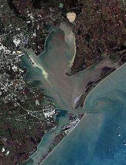 Galveston Bay with Trinity Bay at the top | |
| Location | Texas Gulf Coast |
| Coordinates | 29°40′57″N 94°47′31″W / 29.68250°N 94.79194°WCoordinates: 29°40′57″N 94°47′31″W / 29.68250°N 94.79194°W |
| Type | Bay |
| River sources | Trinity River |
| Ocean/sea sources | Galveston Bay/Gulf of Mexico |
| Basin countries | United States |
| Settlements | Anahuac, Greater Houston |
Trinity Bay is the northeast portion of Galveston Bay, bordered by Chambers and Harris counties in Texas, United States. The bay, approximately 20 miles (32 km) long, heads at the mouth of the Trinity River.[1] Trinity Bay is separated from the main part of Galveston Bay by the San Jacinto River, part of the Houston Ship Channel.
Trinity Bay fronts on the vast network of Chambers County marshes and prairie land. The Trinity Basin contributes 54% of the total bay system inflow for the Galveston Bay complex.[2] Near the head of the bay sits the town of Anahuac. Closer to the San Jacinto river lies the community of Beach City. The city of Baytown also lies near the bay although it does not actually reach its shores. Some smaller communities hug the shores of the bay as well. Much of the area near the shore is semi-rural or undeveloped, particularly the Anahuac National Wildlife Refuge which lies between Trinity Bay and East Bay, another segment of the Galveston Bay complex.
References
- ↑ Leatherwood, Art: Trinity Bay from the Handbook of Texas Online. Retrieved 30 Oct 2009. Texas State Historical Association
- ↑ "Galveston Bay: Excerpts from 'A State of the Bay: A Characterization of the Galveston Bay Ecosystem' by the Galveston Bay National Estuary Program". Texas Space Grant Consortium. Retrieved 18 Jan 2010.
| Large cities |  | |
|---|---|---|
| Other cities | ||
| CDPs and non- municipalities | ||
| Counties | ||
| Subregions | ||
| Bodies of water | ||
| Major ports | ||
| Nature preserves | ||
| Counties |  | |
|---|---|---|
| "Principal" cities | ||
| Other cities |
For a complete listing, see list of cities and towns in Houston–The Woodlands–Sugar Land MSA | |
| Unincorporated areas | ||
| Bodies of water | ||