Trawden Forest
| Trawden Forest | |
 Trawden countryside |
|
 Trawden Forest |
|
| Population | 2,765 (2011) |
|---|---|
| OS grid reference | SD9139 |
| Civil parish | Trawden Forest |
| District | Pendle |
| Shire county | Lancashire |
| Region | North West |
| Country | England |
| Sovereign state | United Kingdom |
| Post town | BURNLEY |
| Postcode district | BB12 |
| Dialling code | 01282 |
| Police | Lancashire |
| Fire | Lancashire |
| Ambulance | North West |
| EU Parliament | North West England |
| UK Parliament | Pendle |
|
|
Coordinates: 53°50′35″N 2°08′13″W / 53.843°N 2.137°W
Trawden Forest is a civil parish in the Pendle district of Lancashire, England. It has a population of 2,765,[1] and contains the village of Trawden (formerly called Beardshaw) and the hamlets of Cottontree, Winewall and Wycoller. Boulsworth Hill is a well known local landmark situated within the parish. It takes its name from a medieval royal forest or "chase" which was in the same area.
Trawden was once a township in the ancient parish of Whalley. This became a civil parish in 1866, forming an urban district from 1894.[2]
The parish adjoins the Pendle parishes of Nelson, Colne and Laneshaw Bridge, the Burnley parish of Briercliffe and West Yorkshire.
According to the United Kingdom Census 2011, the parish has a population of 2,765,[1] an increase from 2,580 in the 2001 census.[3]
Media gallery
 Watersheddles reservoir
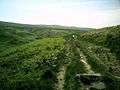 The Brontë Way crossing Brink Ends Moor
 Church of St Mary the Virgin, Trawden
 Wycoller Beck
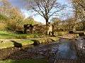 The ruins of Wycoller Hall
See also
References
Citations
- 1 2 "Key Figures for 2011 Census: Key Statistics". Office for National Statistics. Retrieved 1 July 2015.
- ↑ "Trawden Tn/CP through time". visionofbritain.org.uk. GB Historical GIS / University of Portsmouth. Retrieved 27 June 2015.
- ↑ Office for National Statistics : Census 2001 : Parish Headcounts : Pendle Retrieved 2009-09-18
External links
![]() Media related to Trawden Forest at Wikimedia Commons
Media related to Trawden Forest at Wikimedia Commons