Tours
| Tours | ||
|---|---|---|
|
Town hall and Place Jean Jaurès | ||
| ||
 Tours | ||
|
Location within Centre-Val de Loire region  Tours | ||
| Coordinates: 47°23′37″N 0°41′21″E / 47.3936°N 0.6892°ECoordinates: 47°23′37″N 0°41′21″E / 47.3936°N 0.6892°E | ||
| Country | France | |
| Region | Centre-Val de Loire | |
| Department | Indre-et-Loire | |
| Arrondissement | Tours | |
| Government | ||
| • Mayor (2014–2020) | Serge Babary | |
| Area1 | 34.36 km2 (13.27 sq mi) | |
| Population (2012)2 | 134,978 | |
| • Density | 3,900/km2 (10,000/sq mi) | |
| Time zone | CET (UTC+1) | |
| • Summer (DST) | CEST (UTC+2) | |
| INSEE/Postal code | 37261 / 37000, 37100, 37200 | |
| Elevation | 44–109 m (144–358 ft) | |
|
1 French Land Register data, which excludes lakes, ponds, glaciers > 1 km² (0.386 sq mi or 247 acres) and river estuaries. 2 Population without double counting: residents of multiple communes (e.g., students and military personnel) only counted once. | ||


Tours (French pronunciation: [tuʁ]) is a city located in the centre-west of France. It is the administrative centre of the Indre-et-Loire department and the largest city in the Centre-Val de Loire region of France (although it is not the capital, which is the region's second-largest city, Orléans). In 2012, the city of Tours had 134,978 inhabitants, while the population of the whole metropolitan area was 483,744.
Tours stands on the lower reaches of the River Loire, between Orléans and the Atlantic coast. The surrounding district, the traditional province of Touraine, is known for its wines, for the alleged perfection (as perceived by some speakers and for historical reasons) of its local spoken French, and for the Battle of Tours (732). The city is also the end-point of the annual Paris–Tours cycle race.
History
In Gallic times the city was important as a crossing point of the Loire. Becoming part of the Roman Empire during the 1st century AD, the city was named "Caesarodunum" ("hill of Caesar"). The name evolved in the 4th century when the original Gallic name, Turones, became first "Civitas Turonum" then "Tours". It was at this time that the amphitheatre of Tours, one of the five largest amphitheatres of the Empire, was built. Tours became the metropolis of the Roman province of Lugdunum towards 380–388, dominating the Loire Valley, Maine and Brittany. One of the outstanding figures of the history of the city was Saint Martin, second bishop who shared his coat with a naked beggar in Amiens. This incident and the importance of Martin in the medieval Christian West made Tours, and its position on the route of pilgrimage to Santiago de Compostela, a major centre during the Middle Ages.
Middle Ages
In the 6th century Gregory of Tours, author of the Ten Books of History, made his mark on the town by restoring the cathedral destroyed by a fire in 561. Saint Martin's monastery benefited from its inception, at the very start of the 6th century from patronage and support from the Frankish king, Clovis, which increased considerably the influence of the saint, the abbey and the city in Gaul. In the 9th century, Tours was at the heart of the Carolingian Rebirth, in particular because of Alcuin abbot of Marmoutier.
In 732 AD, Abdul Rahman Al Ghafiqi and a large army of Muslim horsemen from Al-Andalus advanced 500 kilometres (311 miles) deep into France, and were stopped at Tours by Charles Martel and his infantry igniting the Battle of Tours. The outcome was defeat for the Muslims, preventing France from Islamic conquest. In 845, Tours repulsed the first attack of the Viking chief Hasting (Haesten). In 850, the Vikings settled at the mouths of the Seine and the Loire. Still led by Hasting, they went up the Loire again in 852 and sacked Angers, Tours and the abbey of Marmoutier.
During the Middle Ages, Tours consisted of two juxtaposed and competing centres. The "City" in the east, successor of the late Roman 'castrum', was composed of the archiepiscopal establishment (the cathedral and palace of the archbishops) and of the castle of Tours, seat of the authority of the Counts of Tours (later Counts of Anjou) and of the King of France. In the west, the "new city" structured around the Abbey of Saint Martin was freed from the control of the City during the 10th century (an enclosure was built towards 918) and became "Châteauneuf". This space, organized between Saint Martin and the Loire, became the economic centre of Tours. Between these two centres remained Varennes, vineyards and fields, little occupied except for the Abbaye Saint-Julien established on the banks of the Loire. The two centres were linked during the 14th century.

Tours became the capital of the county of Tours or Touraine, territory bitterly disputed between the counts of Blois and Anjou – the latter were victorious in the 11th century. It was the capital of France at the time of Louis XI, who had settled in the castle of Montils (today the castle of Plessis in La Riche, western suburbs of Tours), Tours and Touraine remained until the 16th century a permanent residence of the kings and court. The rebirth gave Tours and Touraine many private mansions and castles, joined together to some extent under the generic name of the Châteaux of the Loire. It is also at the time of Louis XI that the silk industry was introduced – despite difficulties, the industry still survives to this day.
16th–18th centuries
Charles IX passed through the city at the time of his royal tour of France between 1564 and 1566, accompanied by the Court and various noblemen: his brother the Duke of Anjou, Henri de Navarre, the cardinals of Bourbon and Lorraine. At this time, the Catholics returned to power in Angers: the intendant assumed the right to nominate the aldermen. The Massacre of Saint-Barthelemy was not repeated at Tours. The Protestants were imprisoned by the aldermen – a measure which prevented their extermination. The permanent return of the Court to Paris and then Versailles marked the beginning of a slow but permanent decline. Guillaume the Metayer (1763–1798), known as Rochambeau, the well known counter-revolutionary chief of Mayenne, was shot there on Thermidor 8, year VI.
19th–20th centuries
However, it was the arrival of the railway in the 19th century which saved the city by making it an important nodal point. The main railway station is known as Tours-Saint-Pierre-des-Corps. At that time, Tours was expanding towards the south into a district known as the Prébendes. The importance of the city as a centre of communications contributed to its revival and, as the 20th century progressed, Tours became a dynamic conurbation, economically oriented towards the service sector.
First World War
The city was greatly affected by the First World War. A force of 25,000 American soldiers arrived in 1917, setting up textile factories for the manufacture of uniforms, repair shops for military equipment, munitions dumps, an army post office and an American military hospital at Augustins. Thus Tours became a garrison town with a resident general staff. The American presence is remembered today by the Woodrow Wilson bridge over the Loire, which was officially opened in July 1918 and bears the name of the man who was President of the USA from 1913 to 1921. Three American air force squadrons, including the 492nd, were based at the Parçay-Meslay airfield, their personnel playing an active part in the life of the city. Americans paraded at funerals and award ceremonies for the Croix de Guerre; they also took part in festivals and their YMCA organised shows for the troops. Some men married girls from Tours.
Inter-war years
In 1920, the city was host to the Congress of Tours, which saw the creation of the French Communist Party.
Second World War
Tours was also marked by the Second World War. In 1940 the city suffered massive destruction, and for four years it was a city of military camps and fortifications. From 10 to 13 June 1940, Tours was the temporary seat of the French government before its move to Bordeaux. German incendiary bombs caused a huge fire which blazed out of control from 20 to 22 June and destroyed part of the city centre. Some architectural masterpieces of the 16th and 17th centuries were lost, as was the monumental entry to the city. The Wilson Bridge (known locally as the 'stone bridge') carried a water main which supplied the city; the bridge was dynamited to slow the progress of the German advance. With the water main severed and unable to extinguish the inferno, the inhabitants had no option but to flee to safety. More heavy air raids by Allied forces devastated the area around the railway station in 1944, causing several hundred deaths.
Post-war developments
A plan for the rebuilding of the downtown area drawn up by the local architect Camille Lefèvre was adopted even before the end of the war. The plan was for 20 small quadrangular blocks of housing to be arranged around the main road (la rue Nationale), which was widened. This regular layout attempted to echo, yet simplify, the 18th-century architecture. Pierre Patout succeeded Lefèvre as the architect in charge of rebuilding in 1945. At one time there was talk of demolishing the southern side of the rue Nationale in order to make it in keeping with the new development.
The recent history of Tours is marked by the personality of Jean Royer, who was Mayor for 36 years and helped to save the old town from demolition by establishing one of the first Conservation Areas. This example of conservation policy would later inspire the Malraux Law for the safeguarding of historic city centres. In the 1970s, Jean Royer also extended the city to the south by diverting the course of the River Cher to create the districts of Rives du Cher and des Fontaines; at the time, this was one of the largest urban developments in Europe. In 1970, the François Rabelais University was founded; this is centred on the bank of the Loire in the downtown area, and not – as it was then the current practice – in a campus in the suburbs. The latter solution was also chosen by the twin university of Orleans. Royer's long term as Mayor was, however, not without controversy, as exemplified by the construction of the practical – but aesthetically unattractive – motorway which runs along the bed of a former canal just 1,500 metres (4,900 feet) from the cathedral. Another bone of contention was the original Vinci Congress Centre by Jean Nouvel. This project incurred debts although it did, at least, make Tours one of France's principal conference centres.
Jean Germain, a member of the Socialist Party, became Mayor in 1995 and made debt reduction his priority. Ten years later, his economic management is regarded as much wiser than that of his predecessor, the financial standing of the city having returned to a stability. However, the achievements of Jean Germain are criticised by the municipal opposition for a lack of ambition: no large building projects comparable with those of Jean Royer have been instituted under his double mandate. This position is disputed by those in power, who affirm their policy of concentrating on the quality of life, as evidenced by urban restoration, the development of public transport and cultural activities.
Climate
Tours has an oceanic climate that is very mild for such a northerly latitude. Summers are influenced by its inland position, resulting in frequent days of 25 °C (77 °F) or warmer, whereas winters are kept mild by Atlantic air masses.
| Climate data for Tours (1981–2010 averages) | |||||||||||||
|---|---|---|---|---|---|---|---|---|---|---|---|---|---|
| Month | Jan | Feb | Mar | Apr | May | Jun | Jul | Aug | Sep | Oct | Nov | Dec | Year |
| Record high °C (°F) | 16.9 (62.4) |
20.8 (69.4) |
23.7 (74.7) |
29.2 (84.6) |
31.8 (89.2) |
36.7 (98.1) |
37.5 (99.5) |
39.8 (103.6) |
34.5 (94.1) |
29.0 (84.2) |
22.3 (72.1) |
18.5 (65.3) |
39.8 (103.6) |
| Average high °C (°F) | 7.3 (45.1) |
8.5 (47.3) |
12.3 (54.1) |
15.2 (59.4) |
19.1 (66.4) |
22.8 (73) |
25.5 (77.9) |
25.4 (77.7) |
21.8 (71.2) |
16.8 (62.2) |
10.9 (51.6) |
7.5 (45.5) |
16.1 (61) |
| Average low °C (°F) | 2.0 (35.6) |
1.9 (35.4) |
3.9 (39) |
5.6 (42.1) |
9.2 (48.6) |
12.1 (53.8) |
14.0 (57.2) |
13.7 (56.7) |
11.1 (52) |
8.6 (47.5) |
4.6 (40.3) |
2.5 (36.5) |
7.5 (45.5) |
| Record low °C (°F) | −17.4 (0.7) |
−14.2 (6.4) |
−10.3 (13.5) |
−3.4 (25.9) |
−0.6 (30.9) |
2.6 (36.7) |
4.3 (39.7) |
4.8 (40.6) |
0.9 (33.6) |
−2.3 (27.9) |
−7.1 (19.2) |
−18.5 (−1.3) |
−18.5 (−1.3) |
| Average precipitation mm (inches) | 66.2 (2.606) |
55.8 (2.197) |
50.3 (1.98) |
55.8 (2.197) |
62.3 (2.453) |
46.1 (1.815) |
53.2 (2.094) |
42.5 (1.673) |
53.2 (2.094) |
70.9 (2.791) |
68.0 (2.677) |
71.3 (2.807) |
695.6 (27.386) |
| Average precipitation days | 11.9 | 9.5 | 9.9 | 9.6 | 9.8 | 7.0 | 6.9 | 6.2 | 7.8 | 10.5 | 11.2 | 11.4 | 111.6 |
| Average snowy days | 2.4 | 2.9 | 1.8 | 0.7 | 0.1 | 0.0 | 0.0 | 0.0 | 0.0 | 0.0 | 1.0 | 1.7 | 10.6 |
| Average relative humidity (%) | 87 | 84 | 79 | 74 | 77 | 75 | 72 | 73 | 77 | 84 | 87 | 89 | 79.8 |
| Mean monthly sunshine hours | 69.9 | 90.3 | 144.2 | 178.5 | 205.6 | 228.0 | 239.4 | 236.4 | 184.7 | 120.6 | 76.7 | 59.2 | 1,833.3 |
| Source #1: Météo France[1][2] | |||||||||||||
| Source #2: Infoclimat.fr (humidity and snowy days, 1961–1990)[3] | |||||||||||||
Sights


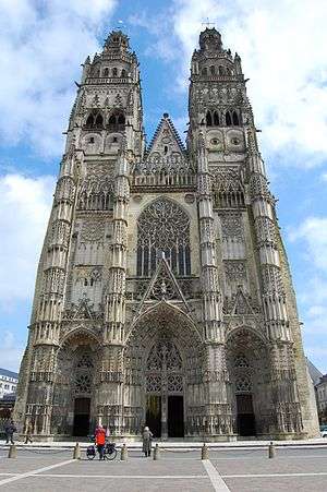
Tours Cathedral
The cathedral of Tours, dedicated to Saint Gatien, its canonized first bishop, was begun about 1170 to replace the cathedral that was burnt out in 1166, during the dispute between Louis VII of France and Henry II of England. The lowermost stages of the western towers (illustration, above left) belong to the 12th century, but the rest of the west end is in the profusely detailed Flamboyant Gothic of the 15th century, completed just as the Renaissance was affecting the patrons who planned the châteaux of Touraine. These towers were being constructed at the same time as, for example, the Château de Chenonceau.
When the 15th-century illuminator Jean Fouquet was set the task of illuminating Josephus's Jewish Antiquities, his depiction of Solomon's Temple was modeled after the nearly-complete cathedral of Tours. The atmosphere of the Gothic cathedral close permeates Honoré de Balzac's dark short novel of jealousy and provincial intrigues, Le Curé de Tours (The Curate of Tours) and his medieval story Maitre Cornélius opens within the cathedral itself.
Other points of interest
Language
Before the French Revolution, the inhabitants of Tours (Les Tourangeaux) were renowned for speaking the "purest" form of French in the entire country.[4] As their accent was that of the court, the pronunciation of Touraine was traditionally regarded as the most standard pronunciation of the French language, until the 19th century when the standard pronunciation of French shifted to that of Parisian bourgeoisie.[5] This is explained by the fact that the court of France was living in Touraine between 1430 and 1530 and concomitantly French, the language of the court, has become the official language of the entire kingdom.
A Council of Tours in 813 decided that priests should preach sermons in vulgar languages because the common people could no longer understand classical Latin.This was the first official recognition of an early French language distinct from Latin, and can be considered as the birth date of French.
The ordinance of Montils-lès-Tours, promulgated by Charles VII in 1454, made it mandatory to write, in the native language of the area, the oral customs which have force of law.
An ordinance of Charles VIII (born in Amboise, near Tours) in 1490 and one of Louis XII (born in Blois, near Tours) in 1510 broaden the scope of the ordinance of Charles VII.
Finally the ordinance of Villers-Cotterêts, signed into law by Francis I in 1539, called for the use of French in all legal acts, notarised contracts and official legislation to avoid any linguistic confusion.
Gregory of Tours wrote in the 6th century that some people in this area could still speak Gaulish.
City
The city of Tours has a population of 140,000 and is called "Le Jardin de la France" ("The Garden of France"). There are several parks located within the city. Tours is located between two rivers, the Loire to the north and the Cher to the south. The buildings of Tours are white with blue slate (called Ardoise) roofs; this style is common in the north of France, while most buildings in the south of France have terracotta roofs .
Tours is famous for its original medieval district, called le Vieux Tours. Unique to the Old City are its preserved half-timbered buildings and la Place Plumereau, a square with busy pubs and restaurants, whose open-air tables fill the centre of the square. The Boulevard Beranger crosses the Rue Nationale at the Place Jean-Jaures and is the location of weekly markets and fairs.
Tours is famous for its many bridges crossing the river Loire. One of them, the Pont Wilson, collapsed in 1978, but was rebuilt just like it was before.
Near the cathedral, in the garden of the ancient Palais des Archevêques (now Musée des Beaux-Arts), is a huge cedar tree planted by Napoleon . The garden also has in an alcove a stuffed elephant, Fritz. He escaped from the Barnum and Bailey circus during their stay in Tours in 1902. He went mad and had to be shot down, but the city paid to honor him, and he was stuffed as a result.
Tours is home to François Rabelais University, the site of one of the most important choral competitions, called Florilège Vocal de Tours International Choir Competition, and is a member city of the European Grand Prix for Choral Singing.
Transport

Today, with its extensive rail (including TGV) and autoroute links to the rest of the country, Tours is a jumping-off point for tourist visits to the Loire Valley and the royal chateaux.
Tours is on one of the main lines of the TGV. It is possible to travel to the west coast at Bordeaux in two and a half hours, to the Mediterranean coast via Avignon and from there to Spain and Barcelona, or to Lyon, Strasbourg and Lille. It takes less than one hour by train from Tours to Paris by TGV and one hour and a half to Charles de Gaulle airport. Tours has two main stations: the central station Gare de Tours, and Gare de Saint-Pierre-des-Corps, just outside the centre, the station used by trains that do not terminate in Tours.
Tours Loire Valley Airport connects the Loire Valley to London Stansted Airport, Marseille and Porto. Scheduled flights to Dublin and Manchester as well as charter flights to Ajaccio and Figari are also available during the summer.
Tours has a tram system (started at the end of August 2013 — 21 Citadis trams were ordered from Alstom designed by RCP Design Global.[6]), and a bus service, the main central stop being Jean Jaures, which is next to the Hôtel de Ville, and rue Nationale, the high street of Tours. The tram and bus networks are operated by Fil Bleu and they share a ticketing system.
Tours does not have a metro rail system.
Catholics from Tours

Tours is a special place for Catholics who follow the devotion to the Holy Face of Jesus and the adoration of the Blessed Sacrament. It was in Tours in 1843 that a Carmelite nun, Sister Marie of St Peter reported a vision which started the devotion to the Holy Face of Jesus, in reparation for the many insults Christ suffered in His Passion. The Golden Arrow Prayer was first made public by her in Tours.
The Venerable Leo Dupont also known as The Holy Man of Tours lived in Tours at about the same time. In 1849 he started the nightly adoration of the Blessed Sacrament in Tours, from where it spread within France. Upon hearing of Sister Marie of St Peter’s reported visions, he started to burn a vigil lamp continuously before a picture of the Holy Face of Jesus and helped spread the devotion within France. The devotion was eventually approved by Pope Pius XII in 1958 and he formally declared the Feast of the Holy Face of Jesus as Shrove Tuesday (the Tuesday before Ash Wednesday) for all Roman Catholics.[7] The Oratory of the Holy Face on Rue St. Etienne in Tours receives many pilgrims every year.
Tours was the site of the episcopal activity of St. Martin of Tours and has further Christian connotations in that the pivotal Battle of Tours in 732 is often considered the very first decisive victory over the invading Islamic forces, turning the tide against them. The battle also helped lay the foundations of the Carolingian Empire[8]
Notable natives and residents
| Historical population | ||
|---|---|---|
| Year | Pop. | ±% |
| 1793 | 21,000 | — |
| 1800 | 20,240 | −3.6% |
| 1806 | 21,703 | +7.2% |
| 1821 | 21,928 | +1.0% |
| 1831 | 23,235 | +6.0% |
| 1836 | 26,669 | +14.8% |
| 1841 | 30,072 | +12.8% |
| 1846 | 30,766 | +2.3% |
| 1851 | 33,530 | +9.0% |
| 1856 | 38,055 | +13.5% |
| 1861 | 41,061 | +7.9% |
| 1866 | 42,450 | +3.4% |
| 1872 | 43,368 | +2.2% |
| 1876 | 48,325 | +11.4% |
| 1881 | 52,209 | +8.0% |
| 1886 | 59,585 | +14.1% |
| 1891 | 60,335 | +1.3% |
| 1896 | 63,267 | +4.9% |
| 1901 | 64,695 | +2.3% |
| 1906 | 67,601 | +4.5% |
| 1911 | 73,398 | +8.6% |
| 1921 | 75,096 | +2.3% |
| 1926 | 77,192 | +2.8% |
| 1931 | 78,585 | +1.8% |
| 1936 | 83,753 | +6.6% |
| 1946 | 80,044 | −4.4% |
| 1954 | 83,618 | +4.5% |
| 1962 | 92,944 | +11.2% |
| 1968 | 128,120 | +37.8% |
| 1975 | 140,686 | +9.8% |
| 1982 | 132,209 | −6.0% |
| 1990 | 129,509 | −2.0% |
| 1999 | 132,677 | +2.4% |
| 2006 | 136,942 | +3.2% |
| 2009 | 135,218 | −1.3% |
| 2011 | 134,633 | −0.4% |
| 2013 | 134,803 | +0.1% |
Tours was the birthplace of
11th-18th century
- Berengarius of Tours (999–1088), theologian
- Bernard of Tours (fl. 1147, d. before 1178), philosopher and poet
- Jean Fouquet (1420–1481), painter
- Abraham Bosse (1604–1676), artist
- Louise de la Vallière (1644–1710), courtesan
- Philippe Néricault Destouches (1680–1754), dramatist
- Jean Baudrais (1749–1832), 18th-century French playwright
- Nicolas Heurteloup (1750-1812), surgeon
- Philippe Musard (1792-1859), conductor and composer
- Gabriel Lamé (1795–1870), mathematician
- Honoré de Balzac (1799–1850), novelist
.jpg)

19th century
- André-Michel Guerry (1802-1866), lawyer and statistician
- Théophile Archambault (1806-1863), psychiatrist
- Ernest Goüin (1815–1885), French engineer
- Marie of St Peter (1816–1848), mystic carmelite nun
- Philippe de Trobriand (1816–1897), author, American military officer
- Emile Delahaye (1843–1905), automobile pioneer
- Georges Courteline (1858–1929), dramatist and novelist
- Daniel Mendaille (1885–1963), stage and film actor
20th century
- Paul Nizan (1905-1940), novelist and philosopher
- Yves Bonnefoy (1923-2016), poet
- Paul Guers (1927) (Paul Jacques Dutron), actor
- Philippe Lacoue-Labarthe, (1940-2007), philosopher, literary critic and translator
- Jean-Louis Bruguière, (born 1943), top French investigating judge
- Jean Chalopin (born 1950), television and movie producer, director and writer
- Jacques Villeret, actor (1951-2005)
- Dominique Bussereau, (born 1952), politician
- Yves Ker Ambrun, (born 1954), known as YKA, cartoonist
- Laurent Petitguillaume (born 1960), radio and television host
- Luc Delahaye, (born 1962), photographer
- Stéphane Audeguy, (born 1964), writer, literary critic and teacher
- Pascal Hervé, (born 1964), cyclist
- Laurent Mauvignier, (born 1967), writer
- Xavier Gravelaine, (born 1968), football player
- Nâdiya (born 1973), singer
- Harry Roselmack (born 1973) television presenter
- Ludovic Roy (born 1977) footballer
- Zaz (born 1980), singer
- Luc Ducalcon (born 1984), rugby union player
- Josselin Ouanna (born 1986), tennis player

International relations
Tours is twinned with:
 Mülheim an der Ruhr, Germany, since 1962
 Segovia, Spain, since 1972
 Parma, Italy, since 1976
 Luoyang, People's Republic of China, since 1982
 Springfield, Missouri, USA, since 1984
 Trois-Rivières, Canada, since 1987
 Takamatsu, Japan, since 1988
 Braşov, Romania, since 1990
- Minneapolis, Minnesota USA, since 1991

Jardin de la Préfecture (central park). 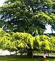
Giant Cedar tree. 

Place Plumereau. 
Slate rooves of Tours. 
Looking towards central Tours from the north bank of the River Loire, adjacent to the Pont Mirabeau.
See also
- Bishop of Tours
- Tours FC – a soccer club based in the town
- Listing of the work of Jean Antoine Injalbert-French sculptor Sculptor of Tours railway station statues also those on Tours Hotel de Ville.
- Marcel Gaumont. Sculptor of war memorial
References
- ↑ "Données climatiques de la station de Tours" (in French). Meteo France. Retrieved December 31, 2015.
- ↑ "Climat Centre-Val de Loire" (in French). Meteo France. Retrieved December 31, 2015.
- ↑ "Normes et records 1961-1990: Tours - St Symphorien (37) - altitude 112m" (in French). Infoclimat. Retrieved December 31, 2015.
- ↑ "Tours, France". Retrieved 3 August 2012.
- ↑ Montvalon, Jean-Baptiste de. "Pourquoi les accents régionaux résistent en France". Le Monde.fr (in French). ISSN 1950-6244. Retrieved 2015-07-19.
- ↑ "Tours selects Citadis and APS". Railway Gazette International. London. 14 September 2010. Retrieved 15 September 2010.
- ↑ Dorothy Scallan. "The Holy Man of Tours." (1990) ISBN 0-89555-390-2
- ↑ Davis, Paul K. (1999) "100 Decisive Battles From Ancient Times to the Present" ISBN 0-19-514366-3
Further reading
- Practical Tours, the comprehensive guide to living in Tours, Tours: Stéphanie Ouvrard, 2013
External links
| Wikimedia Commons has media related to Tours. |
| Wikivoyage has a travel guide for Tours. |
- Official website (French)
- INSEE commune file
- Tours on French version of Wikipedia
- Architecture of Tours
- François Rabelais University, Tours
- Satellite picture by Google Maps
|