River Torrens
| River Torrens | |
|---|---|
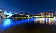
 View of Elder Park, the Riverside Precinct and the Torrens Lake, before construction of the pedestrian bridge in 2014. | |
| Basin | |
| Main source |
Mount Pleasant, Mount Lofty Ranges 480 m (1,570 ft) |
| River mouth | Gulf St Vincent at Henley Beach South (Man-made) |
| Basin size | ~508 km2 (196 sq mi)[1] |
| Physical characteristics | |
| Length | ~85 kilometres (53 mi) |
| Discharge |
|

The River Torrens /ˈtɒrənz/ is the most significant river of the Adelaide Plains and was one of the reasons for the siting of the city of Adelaide, capital of South Australia. It flows 85 kilometres (53 mi) from its source in the Adelaide Hills near Mount Pleasant, across the Adelaide Plains, past the city centre and empties into Gulf St Vincent between Henley Beach South and West Beach. The upper stretches of the river and the reservoirs in its watershed supply a significant part of the city's water supply. The river's long linear parks and a constructed lake in the lower stretch are iconic of the city.
At its 1836 discovery an inland bend was chosen as the site of the Adelaide city centre and North Adelaide. The river is named after Colonel Robert Torrens, chairman of the colonial commissioners and a significant figure in the city's founding. The river is also known by its native Kaurna name Karra wirra-parri. The river and its tributaries are highly variable in flow, and together drain an area of 508 square kilometres (196 sq mi). They range from sometimes raging torrents, damaging bridges and flooding city areas, to trickles and completely dry in summer. Winter and spring flooding has prompted the construction of flood reduction works. A constructed sea outlet, landscaped linear parks and three holding reservoirs contain peak flow.
The river's flora and fauna have been both deliberately and accidentally impacted since settlement. In the 19th century, native forests were cleared, gravel removed for construction and many foreign species introduced. With construction of the linear parks, many species native to the river have been replanted, and introduced species have been controlled as weeds. Since European settlement the river has been a frequently touted tourist attraction. During the early years of settlement, the river acted as both the city's primary water source and main sewer, leading to outbreaks of typhus and cholera.[3]
Physiography

The River Torrens runs largely westward from the Adelaide Hills, through the centre of Adelaide to the Gulf St Vincent. It originates close to the eastern fault scarp of the Mount Lofty Ranges, near Mount Pleasant, approximately 480 metres (1,575 ft) above sea level. It runs predominantly along faulted north-south ground structures, which were formed over 250 million years ago during the Paleozoic era then further dislocated during the Cretaceous and earliest Tertiary. There is a 400 metre subsidence along the Para Fault which also affects the rivers flow. This subsidence was formed in the last two million years, after the Pliocene era.[4]
From its origin to Birdwood the river follows rolling, relatively level country before entering a hilly section that continues to Gumeracha. The river then follows sedimentary rock strata before entering a gorge after Cudlee Creek. It flows through the gorge to Athelstone, passing over the Eden Fault Zone of the Adelaide Hills face and associated escarpment. After the scarp it flows over sedimentary rocks of varying resistance to erosion, which has led to interspersed narrows and broad basins.[4] From the base of the Adelaide Hills to Adelaide's central business district it runs in a shallow valley with a terraced floor, then down the slope of its own alluvial fan. The structure of this fan shows that the river formerly entered Gulf St Vincent via the Port River. Over time the Torrens deposited sediment, choking its own outflow; becoming locked behind coastal sand dunes and forming the swampy areas of the Cowandilla Plains and the reedbeds.[4]
Tributaries

The Torrens is fed by numerous seasonal creeks, which are dry for most of the year. There are five main creeks that join from the south side as it crosses the Adelaide Plains east of Adelaide, and at least five more in its path through the Adelaide Hills.[5] The plains tributaries, known as First to Fifth Creeks, with First being the closest to Adelaide's city-centre and the rest numbered consecutively eastward, were originally named Greenhill, Hallett, Todd, Anstey and Ormsley rivulets respectively. They flow vigorously in winter and spring but are otherwise dry, except for small flows in limited areas upstream.[6] "Moriatta" a Kaurna word meaning "ever flowing" is now the official name of Fourth Creek. This name has been adapted to Morialta which is now the name of an electoral district, school and the Morialta Conservation Park through which the creek flows.[7]
First, Second and Third Creeks have been particularly heavily modified. Some sections have been converted to concrete channels; others run through landscaped private gardens and some run in underground pipes. Much of the original vegetation has disappeared from the creeks, particularly those closest to the city. Introduced species including Olives, bamboo, boxthorn, watsonia and blackberries have displaced native flora.[8]
The largest catchment of the Torrens is Sixth Creek in the Adelaide Hills, which joins the Torrens at Castambul on Gorge Road.[9]
Water flow

At the time of European settlement the river was a summertime chain of waterholes bounded by large gum trees. Flowing through the area where the city of Adelaide is sited the river was sometimes invisible beneath its gravel stream bed. It frequently flooded in winter and did not reach the sea, instead ending at coastal dunes where its waters created a vast but shallow freshwater wetlands. These wetlands, known as The Reedbeds after the dominant vegetation, occupied a large area of the western Adelaide Plains and were also fed by other waterways.[3] The river only flowed to the sea through the Port River, Barker Inlet, and Patawalonga River following heavy rain.[10]
The river's catchment area of approximately 500 km2 (193 sq mi) is the largest of any waterway within the Adelaide region. The upper reaches are used to create a potable water supply for metropolitan Adelaide with the river supplying three of Adelaide's eight reservoirs.[3] The upper catchment has an average annual rainfall of between 575 millimetres (22.6 in) at its eastern end to 1,025 millimetres (40.4 in) near Uraidla.[11] The Torrens has a very variable flow leaving early settlers to use trial and error in determining bridge heights, with many bridges consequently being washed away.[12] Due to the variability of Adelaide's climate, flow rates can change from a trickle to flood conditions quickly. On 5 June 1889, prior to major flooding, the flow rate before it entered the suburbs was 0.7 m³/s(cubic metres per second), rising to 129.1 m³/s, 8 days later.[13]
What the River Torrens may be capable of performing for a week or two of the rainy season beyond sweeping down to the swamp the summer filth of Adelaide we cannot guess; but the Torrens at other times is not a river at all, but merely a chain of fresh water pools. At the present moment, its running water may be spanned with the hand and sounded with the forefinger— The Register, 1838[14]
Since settlement it has repeatedly flooded, sometimes with disastrous consequences. Adelaide's western suburbs were especially prone to flooding due to their location on the river's alluvial fan.[15] As development of Adelaide progressed the amount of rainfall required for flooding decreased and consequent damage increased. Increased stormwater runoff, modification of the river's banks and other changes all served to exacerbate the problem. Work done by various groups to minimise flooding was often counter productive with the creation of levees, moving and widening channels and other works simply shifting the flooding elsewhere.[16]
Two early floods were, 18 September 1841 which resulted in two people drowning while trying to cross the river at Klemzig, and 22 September 1844, the largest recorded since settlement began, when "Shands' Brewery" was washed away after the river undermined its foundations.[14] The 1899 flood was particularly widespread with extensive flooding of both the river and its tributaries, after a year with 785.6 millimetres of rain compared to the Adelaide average of 530 millimetres. The river flooded market gardens and farms throughout its hills course causing extensive damage. Norwood was inundated to The Parade, Adelaide to Pirie and Rundle Streets, and many areas west of the city were left in a shallow lake.[17] The river ran 9 feet (2.7 m) deep over the weir near Thorndon Park Reservoir, 3 feet (0.91 m) over the Torrens Lake Weir and 1-foot (0.30 m) over the Morphett Street Bridge. The Underdale (or Holbrooks) Bridge was destroyed, the Torrens Lake weir's bridge damaged, and the Felixstow Bridge over the Fourth Creek washed away.[18]
"Discovery" and naming
The first European sighting of the river was in November 1836 by an exploration party comprising Lieutenant W.G. Field, John Morphett and George Strickland Kingston. The river was named "The Yatala" by the party[19] but later renamed by Surveyor General Colonel William Light after Colonel Robert Torrens, chairman of the South Australian colonisation commissioners.[4] On 29 December 1836 Light announced the location of the new city of Adelaide, 6 miles (9.7 km) inland on the river's banks .[19] The first Europeans to explore the Torrens Gorge to the headwaters and sources of the river were Dr George Imlay and John Hill in January 1838.[20] [21]
In recent years the river has been dually known by the indigenous Kaurna people's name of Karra wirra-parri (meaning river of the Red Gum forest), referring to the dense eucalyptus forest that lined its banks prior to clearing by early settlers. This name, alternatively Karra-weera, only referred to the lake section of the river, between Adelaide and North Adelaide. It was known as Karrundo-ingga at Hindmarsh, Witoingga near the reed beds, and Yertala everywhere when in flood. Yertala has been translated as "water running by the side of a river" and has survived as Yatala in the naming of various places in Adelaide.[19]
Changes after 1836
During early years of colonisation, the surrounding trees were cut down and the river's gravel used in road making and construction of buildings. As the natural environment was removed, the banks were eroded and the riverbed gradually levelled as waterholes filled. By 1878 the river was noted to be a malodorous, black sewer rather than the sylvan stream of the 1830s.[22]
...anything in the guise of a river more ugly than the Torrens would be impossible to either see or describe...
Much of the river's catchment area consists of cleared farmland with run-off captured in private dams to sustain farming over Adelaide's dry summer. Combined with the river's use for potable water this has greatly reduced the overall flow especially in the lower river.
Flood mitigation
A flood mitigation bill was passed in 1917 to not only combat the damage caused by floods but also the public health risk due to the lack of mains sewerage in the western suburbs. Popular opinion favoured diverting the flood waters into their "natural" outlets of the Port and Patawalonga Rivers. The chief engineer of the department of works favoured a cutting through sand dunes near Henley Beach, allowing the river an outlet, mitigating floods and preventing silting of the Port River. He also advocated the construction of a reservoir where the Kangaroo Creek Reservoir is now, to both mitigate floods and provide summer irrigation water for market gardens. Unfortunately the bill lapsed with no action as the government and local councils were unwilling to fund the works.[24] The Millbrook Reservoir opened in 1918 as a summer water source, and flood mitigator if required. A bill was passed in 1923 to enact the earlier plan of cutting through the dunes and adding an upstream regulating weir. Again the bill lapsed due to a lack of commitment from parties on payment.[25]

A major flood in 1931 and another in 1933 led to the latest in a series of government enquiries. In 1934 the "Parliamentary Standing Committee on Public Works" recommended that an outlet for the river be created to accommodate flows of up to 370 m³/s (cubic metres per second) (13,000 ft³/s), covering a 1 in 60 year flood. The work was partly financed by a Commonwealth Government grant with the State Government arranging for the balance. The State Government, western and eastern local councils and the Municipal Tramways Trust shared interest costs. The scheme was enacted in 1935 and largely completed by 1939 with the creation of the "Breakout Creek" channel.[26] The scheme involved diversion of the river at Lockleys (near Adelaide Airport), with the original channel blocked and a new channel created to the sea.[3] The reedbeds and swamps were subsequently drained and some of their area is now the site for the suburb of West Lakes.
Based on recommendations in a 1925 report on flood mitigation, work began in the 1960s on the building of the Kangaroo Creek Reservoir, opened in 1969 with a capacity of 24.4 megalitres[27] It remains the only reservoir damming the river rather than being fed from weirs. The "River Torrens Committee" was formed in 1964 to advise the minister of works on preserving and enhancing the river's natural beauty, and developing it for recreational uses. The "River Torrens Acquisition Act 1970-72" was passed, authorising the purchase of land, in some cases 60 metres back from the top of the river's banks.[28]
By 1980, further development along the riverbanks and removal of levées had reduced the outlet's capacity to a 1 in 35 year flood. A study showed that a 1 in 200 year flood would inundate 13,000 properties; so the Kangaroo Creek dam's level was raised, its spillway modified, the breakout creek channel capacity increased and some bridges reinforced.[29] A development plan was approved in 1981 to purchase land along the length of the river, create a flood mitigating linear park and also to modify the Kangaroo Creek dam further. The sea outlet was enlarged to a capacity of 410 m³/s which now covered a 1 in 200 year flood.[30] When the O-Bahn Busway was opened, the bridges were designed to cope with this scale of flood, although the two bridges in St Peters would likely be awash.[31]
Torrens Lake

The 470 megalitre[32] Torrens Lake was created in 1881 with the construction of a weir, landscaping of Elder Park and modification of the river's bank and surrounds into an English formal park. The lake forms a centrepiece of many Adelaide events and postcard scenes. Elder Park with its iron rotunda was opened on 28 November 1882. The Rotunda is a largely Glasgow built 9 metre high iron bandstand which was funded by Sir Thomas Elder Smith, the park being named after him.[33]
In 1867, prison labour from Adelaide Gaol was used to build a wooden dam near the site of the current weir. The dam was poorly constructed and almost immediately the Torrens washed it away. Construction of a permanent concrete weir was begun in November 1880 and completed, at a cost of £7,000, in 1881. The sluice gates were closed to begin filling the 12-hectare (30-acre) Torrens Lake on 1 July 1881. At the lake's official opening on 21 July 1881 an estimated 40,000, almost the entire population of Adelaide, attended. During the 1889 flood, the weir was overwhelmed, its gates jammed, and in trying to free them the weir's designer John Langdon was crippled.[23] The weir was rebuilt from 1928 to 1929 with its footbridge relocated and the centre section replaced. The gates can now be fully raised and the river allowed to flow unimpeded.[34]


The "Popeye" boats are privately owned recreational ferries that operate on the lake between Elder Park and the Adelaide Zoo. The first boat was launched on the Torrens Lake by Gordon Watts in 1935. It was a 25-foot (7.6 m) boat, built on the banks of the Torrens to hold up to 20 passengers and named Popeye 1. Watts purchased a former Glenelg cruise boat in 1948 and placed it in service as Popeye 2. Over the next two years three new jarrah hulled boats were built at Port Adelaide; carrying 40 passengers each they were numbered Popeye 3 through Popeye 5. Trips on the Popeyes from Elder Park to the zoo became a treasured family outing and the boats hosted weddings and other events.[35] In March 1962 Keith Altman, owner of riverside eatery "Jolley's Boathouse", took over the Popeyes and introduced recreational paddle boats to the river. The Popeyes had a brush with royalty in March 1977 with Popeye 5 ferrying Queen Elizabeth II and Prince Philip followed by a choir in Popeye 4. Prime Minister Malcolm Fraser officially launched three new fibreglass models named Popeyes I, II and III in 1982 as the wooden boats' replacements.[36]
Water use
In the early days of Adelaide, the Torrens was used for bathing, stock watering, rubbish disposal, water supply and as a de facto sewer and drainage sump. This led to a range of health issues until finally, in 1839, when a dysentery outbreak killed 5 children in one day, Governor Gawler forbid bathing, clothes washing and the disposal of animal carcases in the Torrens within 1-mile (1.6 km) of town. The quality of the river's water was not helped by water supply methods. Carters used to drive water carts into the Torrens to refill. To prevent this the State Government built a facility with steam powered pumps and water storage in 1852, from which the carters then filled.[37]
The "Waterworks Act" of 1856 was passed to enable damming of the upstream Torrens for water supply purposes.[38] The resulting "Water Commission" arranged the following year for foundations to be laid for a water supply weir 7 miles (11 km) from Adelaide near Campbelltown. Unsuitable geology and shoddy work by contractors Frost & Watson led to it being washed away in July 1858 and the site abandoned. Engineer Hamilton was replaced by John England. Government then created a Waterworks Department, which started construction of a weir 10 miles (16 km) from the city and reservoir at Thorndon Park in 1859.[39] The weir was completed on 4 June 1860 and the reservoir began supplying piped water in December. Engineer England was found by a Select Committee to have overpaid the contractors and forced to resign.[40] The water was captured at the weir, piped for storage to the Thorndon Park Reservoir then to a water tower at Kent Town. Water from Kent Town storage was distributed via a manually controlled water system, unmetered for its first six years.[41] Within six years 20,000 citizens in Adelaide and Port Adelaide were connected to reticulated water from the Torrens.[42] By 1872, the 2840 megalitre Hope Valley Reservoir in the foothills of the Adelaide Hills was completed as a storage reservoir, supplied via an aqueduct and tunnel.[43]
Public baths were built in 1861 just north of the current Parliament House. They were supplied with reticulated water from the Torrens and progressively upgraded with the last change a 1940 remodelling including an Olympic size swimming pool and diving tower. The baths were demolished in 1970 to make way for the Adelaide Festival Centre.[44] The 16,500 megalitre Millbrook Reservoir was constructed high in the Adelaide Hills from 1913 to 1918 submerging the town of Millbrook. An earth bank dam fed by mile long tunnel from a weir on the river at Gumeracha, its elevation allows gravity supply of water to Adelaide's eastern suburbs.[45]
Bridges


Due to the river's path through the centre of Adelaide, transport necessitated the construction of many bridges. Prior to the bridges all crossings had been via fords which proved a dangerous practice in winter and spring. The first bridge was one of timber built in 1839 approximately 500 metres west of the current City bridge, but destroyed by floods in September 1844.[33] In 1849 £6000 was allocated to bridge the Torrens. Within four years three wooden bridges had been built and subsequently destroyed in floods.[38] In June 1856 the English manufactured, iron City Bridge was opened, extending King William Street to North Adelaide. It was widened in 1877 then converted into a two-lane bridge in 1884. In 1929 a new wider, concrete bridge was proposed, to be the same width as King William Road and would relieve congestion, particularly on match days at the Adelaide Oval.[46] The bridge was duly replaced in 1931 with the concrete arch structure proposed in 1929.[47] The distinctive lamp fittings and their pylons were designed by South Australian artist John C. Goodchild.[48]
The Victoria Bridge extends from Morphett Street and crosses the rail lines from the Adelaide railway station and the river. The first bridge was opened on 21 June 1871,[38] and over time various bridges have been built on the same site. The current bridge, a prestressed concrete box girder bridge, was opened in March 1968 by then Premier of South Australia Don Dunstan, and Adelaide Lord Mayor Walter Lewis Bridgland. The bridge is constructed as two bridges joined to appear continuous. The first spans North Terrace and the rail lines, and the second the river. The bridge was designed without a central pillar in the river, allowing three lanes of rowers to compete without interference.[49]

The Albert Bridge is adjacent to the Adelaide Zoo and carries Frome Road over the river. A timber bridge was constructed in 1859, west of the current bridge, and named the Old Frome Bridge.[50] The current bridge was named after Prince Albert, royal consort to Queen Victoria, on 7 May 1879.[51] The wrought iron structure is made from three parallel, scalloped girders that were manufactured in England. It is 120 feet (36.6 m) long with a cantilevered span of 60 feet (18 m). The bridge is 43 feet (13 m) wide and originally had a timber deck, which was replaced with concrete in 1922. The coats of arms on the inside of the bridge contains the city's motto, Ut Prosint Omnibus Conjuncti which translates as "united for the common good." The bridge is listed on the "City of Adelaide Heritage Register", the "South Australian Heritage Register" and the "Register of the National Estate". A complete restoration was finished in 1982, with the bridge now appearing as it did at the 1879 opening.[52]
Torrens River Park Pedestrian Bridge east of the zoo, was opened in late 2009 and is well patronised by cyclists.
The Hackney Bridge was first known as the "Second Company Bridge" as the South Australia Company built it. It was built so that wheat farmers from the northern side could access the South Australian Company's flour mill which stood where the Hackney Hotel was later built.[50] The current bridge is the third at the same site; in 1845 "Prescott's Crossing" was built as a timber beam bridge, 1860 saw it replaced with a four span, trussed timber bridge and 5 December 1885 with a 126-foot (38 m) long, 34-foot (10 m) wide truss arch bridge.[53]
University Footbridge connects Victoria Drive, at the rear of University of Adelaide, with University Oval, War Memorial Drive.[54][55] The bridge was conceived in 1928 by an engineering undergraduate at the university and funded with a £26,000 grant from Adelaide City Council. It was designed by university staff under the supervision of Robert Chapman, chief engineer of the South Australian Railways. Construction was delayed until 1937 due to the economic effects of the Great Depression. The bridge has an arch spanning 152 ft (46 m), 20 ft (6.1 m) over the river, and was the first welded bridge in South Australia.[56] A murder that occurred in the vicinity of the bridge on 10 May 1972 resulted in calls to reform South Australia's laws regarding homosexuality. University of Adelaide law lecturer Dr George Duncan was thrown into the river. A plaque on the bridge commemorates his death and the subsequent decriminalisation of homosexuality in South Australia.[57]
Various other bridges have spanned the Torrens including:
- Railway Bridge, Built in 1856 to carry the Port and Gawler Town railway lines. The bridge was constructed 1.5 km from Adelaide railway station.[58]
- Felixstowe Bridge, built in 1873 on OG Road and reconstructed in 1892, 1901, 1924 and 1961. The first bridge was narrow, and hay-laden carts often damaged posts while brushing past them.[50]
- Tennyson Bridge, built 1877 on Stephen Terrace, St Peters, replacing a ford at the same site.[50]
- Ascot Bridge, built in 1970 to connect Ascot Avenue and Lower Portrush Road.
- Dickson's Crossing, built on Darley Road in 1977 to replace a ford.[50]
Flora and fauna

The river was formerly a food source with yabbies, mussels and small fish, however the reduction in water quality, changing of the river's habitat, and introduction of European fish species has led to a reduction in fauna quantity and diversity.[22] Exotic pest species such as the European carp, redfin perch and trout have greatly reduced native fish populations like the big headed gudgeon (Philypnodon grandiceps) but native waterfowl are common along the river with Pacific black ducks, Australian wood ducks, black swans, ibis, egrets and herons amongst the more than 100 species seen. The number of exotic waterfowl species such as mallards has reduced in recent years. In places the steep banks of the river are an ideal habitat for long-necked tortoises.
The river, and its tributaries, had a population of water rats (Hydromys chrysogaster) and Australian swamp rats (Rattus lutreolus). Water rats remain in reduced numbers, but the introduced black rat (Rattus rattus) and brown rat (Rattus norvegicus) have largely supplanted the natives. The house mouse (Mus musculus) is now the most common mammal of the Torrens environ.[59]
Widely found native reeds, sedges and rushes along the upper river are bulrush, knobby club rush, spike rush, common reed, sea rush and pale rush. River red gum (Eucalyptus camaldulensis) and blue gum (Eucalyptus leucoxylon) trees are found along the riverbanks, although sparser than the forest that was seen by European discoverers. Still present are many of the original vegetation species like: Sheoak (Casuarina stricta), native cherry (Exocarpos cupressiformis), native pine (Callitris preissii) and Australia's floral emblem the golden wattle (Acacia pycnantha)[60]
Today's river
From its source the river flows westwards through Birdwood and Gumeracha. It then continues down through Torrens Gorge entering suburban Adelaide at Athelstone with some of its path paralleled by the O-Bahn Busway. It passes between the city-centre and North Adelaide, forming the Torrens Lake between the Adelaide Zoo and a weir opposite Adelaide Gaol. The river then continues the remaining eight kilometres to the sea at Henley Beach South, emptying into Gulf St Vincent via a constructed outlet.
Hope Valley, Millbrook and Kangaroo Creek Reservoirs, which provide water storage for Adelaide, capture the river's flow. These reservoirs form part of the Adelaide Hills catchment, which supplies 60% of Adelaide's water needs in an average year. Adelaide City Council uses water from the lower river to irrigate the city's surrounding parklands.[61] Rubbish accumulation in the lower river is controlled with numerous collection racks, and sediments and other pollutants are filtered through constructed wetlands.[62]
The earliest linear river park in Australia bounds the suburban end of the river. The park is 35 km long with numerous playgrounds walkways and bicycle tracks. On the south bank of the lake, adjacent to the Adelaide Festival Centre, Elder Park is used for the annual Tasting Australia festival, mass singing of christmas carols at the annual "Carols by Candlelight", and other public events throughout the year. The Popeye tourist boats, small paddle boats and Black Swans of the lake are icons of the area and frequently featured in postcard photographs of the city. Due to now-limited natural river flow and stormwater born organic material, the lower river, (particularly the lake), is often polluted with algal blooms and significant levels of E. coli bacteria in spring and summer. Numerous taskforces have been formed to improve the river's water quality, including one created in 2006 by the Minister for the Environment and Conservation.[63]
The river is a used by many for recreation, with the footpaths on the riverbanks often filled with cyclists and joggers. Rowers use the lake for training all year round, and many clubs such as the Adelaide University Boat Club, the Adelaide Rowing Club, and the boat houses of the secondary schools which participate in the annual Head of the River are located upon its banks. Several rowing regattas are held on the Torrens Lake course in the summer months of each year, contested by both club and school crews.
Notes
- ↑ "Torrens River". Australian Government, Bureau of Meteorology. 2007. Retrieved 9 September 2009.
- ↑ Noted as 22.4GL per year in Adelaide coastal waters study (Spring 2004). "Summary of the literature review and stormwater audit (pdf)" (PDF). City to Sea. 1 (4): 2. Retrieved 9 September 2009.
- 1 2 3 4 KESAB. "A LITTLE CATCHMENT HISTORY". Catchment Boards of South Australia. Archived from the original on 3 October 2006. Retrieved 21 November 2006.
New site: http://www.amlrnrm.sa.gov.au Active on 9 September 2009. - 1 2 3 4 Smith & Twidale 1987, p.v
- ↑ Smith & Twidale 1987, Figure 1 (River Torrens Catchment)
- ↑ Warburton J.W. (editor) 1977, p.9
- ↑ Warburton J.W. (editor) 1977, p.25
- ↑ Warburton J.W. (editor) 1977, pp12-14,116-125
- ↑ http://www.sixthcreek.com/index.php?page=watercourse
- ↑ "Wetlands of the catchment". Torrens catchment water management board. 5 July 2005. Archived from the original on 3 October 2006. Retrieved 21 November 2006. This site is LONG dead.
Try: http://www.amlrnrm.sa.gov.au/Caring_for_Water_Seas/Creeks_Rivers/River_Torrens.aspx Retrieved on 9 September 2009. - ↑ Surface Water Group (June 2003). Report DWLBC 20003/24, Surface Water Assessment of the Upper River Torrens Catchment (Figure 16). Adelaide: The Department of Water, Land and Biodiversity Conservation.
- ↑ Smith & Twidale 1987, p.1
- ↑ Smith & Twidale 1987, p.90
- 1 2 Smith & Twidale 1987, p.4
- ↑ Smith & Twidale, July 1988, foreword
- ↑ Smith & Twidale, July 1988, p.2
- ↑ Smith & Twidale 1987, pp.69-78
- ↑ Smith & Twidale 1987, pp.79-84
- 1 2 3 Altmann et al. 1999, p.2
- ↑ Supplement to The Australian, 27 March 1838, and Register, 16 June 1838, p. 3.
- ↑ "SOUTH AUSTRALIA.". The Australian. 27 March 1838. p. 3.
- 1 2 "An Essay on the River Torrens". State Library of South Australia, The Manning Index of South Australian History. Retrieved 9 September 2009.
- 1 2 Altmann et al. 1999, p.19
- ↑ Smith & Twidale, February 1988, p.2
- ↑ Smith & Twidale, July 1988, p.4
- ↑ Smith & Twidale 1989, p.1
- ↑ Smith & Twidale 1989, p.104
- ↑ Smith & Twidale 1989, p.103
- ↑ Smith & Twidale 1989, p.2
- ↑ Smith & Twidale 1989, p.125
- ↑ Smith & Twidale 1989, p.132
- ↑ "Torrens taskforce, storage options". Adelaide and Mount Lofty ranges natural resources management board. 18 April 2007. Archived from the original on 30 August 2007. Retrieved 14 October 2007.
Try: http://www.amlrnrm.sa.gov.au - 1 2 Altmann et al. 1999, p.4
- ↑ Altmann et al. 1999, p.20
- ↑ Altmann et al. 1999, p.21
- ↑ Altmann et al. 1999, p.22
- ↑ Altmann et al. 1999, p.6
- 1 2 3 Altmann et al. 1999, p.3
- ↑ "The Reservoir at Thorndon Park". South Australian Register. Adelaide: National Library of Australia. 18 April 1859. p. 2. Retrieved 16 August 2014. This article contains a lot of useful information about Thorndon Park reservoir.
- ↑ Cumming, D. A. and Moxham, G. They Built South Australia pub. by the authors, Adelaide SA 1986 ISBN 0 9589111 0 X
- ↑ Altmann et al. 1999, p.7
- ↑ Hammerton M. 1986, p.25
- ↑ "Water Supply". Atlas of South Australia 1986. Government of South Australia. Retrieved 9 September 2009.
- ↑ Altmann et al. 1999, p.8
- ↑ Hammerton M. 1986, pp.155-156
- ↑ "New City Bridge". The Advertiser. Adelaide: National Library of Australia. 16 February 1929. p. 14. Retrieved 15 November 2012.
- ↑ Altmann et al. 1999, pp.3,15
- ↑ Joyce Gibberd, 'Goodchild, John Charles (1898–1980)', Australian Dictionary of Biography, National Centre of Biography, Australian National University, published first in hardcopy 1996, accessed online 8 February 2015
- ↑ Altmann et al. 1999, p.18
- 1 2 3 4 5 Lewis H. John 1985, p.57
- ↑ National Library of Australia, TROVE: Opening of the Albert Bridge South Australian Register, 17 May 1879. Accessed 26 January 2014.
- ↑ Altmann et al. 1999, p.10
- ↑ Altmann et al. 1999, p.11
- ↑ University Footbridge, adelaide-in-photos.blogspot.com Retrieved on 9 September 2009.
- ↑ Kemp, Deane; Pickles John. "Fargher, John Adrian (1901–1977)". Australian Dictionary of Biography. Melbourne University Pressdate=1996. pp. 138–139. Retrieved 9 September 2009.
- ↑ Altmann et al. 1999, p.12
- ↑ "Call for release of documents relating to professor's death". Australian Broadcasting Corporation. 10 May 2002. Archived from the original on 17 February 2009. Retrieved 2009-09-09.
- ↑ Thompson & Sampson 2006, p.24
- ↑ Warburton J.W. (editor) 1977, p.23
- ↑ Warburton J.W. (editor) 1977, p.11-14
- ↑ "Water Proofing Adelaide, Exploring the issues – a discussion paper" (PDF). Government of South Australia. Archived from the original (PDF) on 26 February 2007. Retrieved 22 March 2007.
Try: Water Proofing Adelaide A thirst for change 2005–2025 Brochure (pdf 8 pages) and/or Strategy (pdf 64 pages) Both published 2005 and Retrieved on 9 September 2009. - ↑ 2006 signage by the (now defunct) Torrens water catchment board (at Breakout Creek near Henley Beach) showed four constructed wetlands and 12 (existing or in construction) trashracks.
- ↑ Owen, Michael (16 September 2006). "Taskforce to look at ailing Torrens". The Advertiser, Adelaide. News Limited.
References
- Altmann, Keith; Butcher M, Rodda L, Stacey B, Stewien R, Venus R (1999). Ponds, ponts & Pop-eye : notes for an afternoon afloat on Adelaide's River Torrens. North Adelaide: Institution of Engineers Australia, South Australian Division.
- Lewis, H. John (1985). Enfield and the northern villages. Enfield, South Australia: Corporation of the City of Enfield. ISBN 0-85864-090-2.
- Hammerton, Marianne (1986). Water South Australia, A History of the Engineering and Water Supply Department. Adelaide: Wakefield Press. ISBN 0-949268-75-5.
- Payne, Pauline (1996). Thebarton Old and New. Adelaide: Thebarton City Council. ISBN 0-646-30157-8.
- Smith, Derek L.; Twidale C.R. (1987). An Historical account of flooding and related events in the torrens river system from first settlement to 1986. 1, 1836–1899. Adelaide: The engineering and water supply department. ISBN 0-7243-4248-6.
- Smith, Derek L.; Twidale C.R. (February 1988). An Historical account of flooding and related events in the torrens river system from first settlement to 1986. 2, 1900–1917. Adelaide: The engineering and water supply department.
- Smith, Derek L.; Twidale C.R. (July 1988). An Historical account of flooding and related events in the torrens river system from first settlement to 1986. 3, 1918–1930. Adelaide: The engineering and water supply department.
- Smith, Derek L.; Twidale C.R. (1989). An Historical account of flooding and related events in the torrens river system from first settlement to 1986. 4, 1931–1988. Adelaide: The engineering and water supply department.
- Thompson, Malcolm; Sampson Bob (2006). 150 years of the Port Adelaide Railway 1856 to 2006. Port Adelaide: National Railway Museum.
- Warburton, J.W. (editor) (1977). Five creeks of the River Torrens. Adelaide: Department of adult education, University of Adelaide. ISBN 0-85578-336-2.
External links
| Wikimedia Commons has media related to River Torrens. |
- Adelaide & Mount Lofty Ranges Natural Resources Management Board
- State Library Manning Index: River Torrens
Coordinates: 34°55′S 138°36′E / 34.917°S 138.600°E