Topeiros
| Topeiros Τόπειρος | |
|---|---|
 | |
 Topeiros | |
|
Location within the region  | |
| Coordinates: 40°59′N 24°48′E / 40.983°N 24.800°ECoordinates: 40°59′N 24°48′E / 40.983°N 24.800°E | |
| Country | Greece |
| Administrative region | East Macedonia and Thrace |
| Regional unit | Xanthi |
| Area | |
| • Municipality | 312.5 km2 (120.7 sq mi) |
| Population (2011)[1] | |
| • Municipality | 11,544 |
| • Municipality density | 37/km2 (96/sq mi) |
| Time zone | EET (UTC+2) |
| • Summer (DST) | EEST (UTC+3) |
| Vehicle registration | AH |
Topeiros (Greek: Τόπειρος, Turkish: İnhanlı) is a municipality in the Xanthi regional unit, Greece. Population 11,544 (2011). The seat of the municipality is in Evlalo.[2]
History
Topeiros was an ancient Thracian settlement, which in the imperial times evolved into a great urban center survived until the Byzantine period. The city is identified with the late Roman and Byzantine ruins saved a little south of the modern village of Paradeisos, where there is a passage of the river Nestos. The city functioned as tribal, administrative and religious center of the Thracian tribe of Sapaioi.
Thanks to its strategic position, in early 2nd AD century it was rebuilt – according to the Greek type of city-states – by emperor Trajan under his provincial policy intended to urbanization of Thrace. It was then known as Ulpia Topirus in Latin. Within the limits of its territory that stretched on both banks of the river Nestos were a dense network of rural settlements and castles, as well several Roman stations of via Egnatia.[3]
References
- ↑ "Απογραφή Πληθυσμού - Κατοικιών 2011. ΜΟΝΙΜΟΣ Πληθυσμός" (in Greek). Hellenic Statistical Authority.
- ↑ Kallikratis law Greece Ministry of Interior (Greek)
- ↑ D. C. Samsaris, Historical Geography of Western Thrace during the Roman Antiquity (in Greek), Thessaloniki 2005, p. 79-91
Administrative division of the Eastern Macedonia and Thrace Region | ||
|---|---|---|
| Regional unit of Drama | 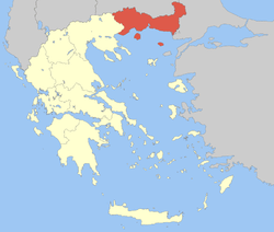 | |
| Regional unit of Evros | ||
| Regional unit of Kavala | ||
| Regional unit of Rhodope | ||
| Regional unit of Thasos | ||
| Regional unit of Xanthi | ||
| ||