Theddlethorpe
| Theddlethorpe | |
 Theddlethorpe |
|
| OS grid reference | TF474890 |
|---|---|
| – London | 135 mi (217 km) S |
| District | East Lindsey |
| Shire county | Lincolnshire |
| Region | East Midlands |
| Country | England |
| Sovereign state | United Kingdom |
| Post town | MABLETHORPE |
| Postcode district | LN12 |
| Police | Lincolnshire |
| Fire | Lincolnshire |
| Ambulance | East Midlands |
| EU Parliament | East Midlands |
| UK Parliament | Louth and Horncastle |
|
|
Coordinates: 53°22′39″N 0°12′53″E / 53.377399°N 0.214610°E
Theddlethorpe comprises two close villages and civil parishes, Theddlethorpe St Helen, and Theddlethorpe All Saints, in the East Lindsey district of the county of Lincolnshire, England. These two villages have operated as one entity for many years. They are situated approximately 3 miles (5 km) north from Mablethorpe and on the coast of the North Sea.
The National Grid-owned Theddlethorpe Gas Terminal processes natural gas extracted from beneath the North Sea for use in the UK.
A section of the seashore of the village is part of the Saltfleetby-Theddlethorpe Dunes National Nature Reserve, which comprises sea dunes and both saltwater and freshwater marshes. The reserve is one of only five locations in the UK where the natterjack toad can be found.
Theddlethorpe St Helen has a primary school.[1]
Theddlethorpe All Saints
53°22′16″N 0°11′55″W / 53.370989°N 0.198730°W
Located about 8 miles (13 km) east from the town of Louth.[2] Population according to the 2001 census was 212,[3] decreasing to 165 at the 2011 Census.[4]
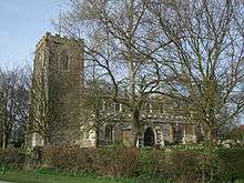
The parish church is dedicated to All Saints and is a Grade I listed building dating from the 12th century, with 1380–1400 and late 17th-century alterations, and minor repairs in 1865-66. It was built of greenstone and limestone and has a 15th-century font. At the west end is preserved the 15th-century wooden pinnacle from the tower roof. In the south aisle chapel is a brass to Sir Robert Hayton who died in 1424. Nearby is the matrix for a double brass of which only one brass shield remains. In the chancel are two early 18th-century marble wall plaques to members of the Newcomen family. A marble monument to Charles Bertie and his wife Mary died 1727, made by Andrew Carpenter, London.[5] All Saints was declared redundant by the Diocese of Lincoln in 1973[6] and it is now in the care of the Churches Conservation Trust.[7]
Hall Farmhouse is a Grade II listed 16th-century red-brick house, altered about 1680 with more alterations in the late 18th and 19th centuries.[8]
Within the parish there is a medieval moat, extant in 1963 but now only visible as cropmarks. A hearth tile bearing the arms of the Angevin family was found when excavation took place in the moated enclosure near Theddlethorpe All Saints church. The house within the moat was called Keleshall.[9]
| Population of Theddlethorpe All Saints Civil Parish | ||||||||||||||||
|---|---|---|---|---|---|---|---|---|---|---|---|---|---|---|---|---|
| Year | 1801 | 1811 | 1821 | 1831 | 1841 | 1851 | 1881 | 1891 | 1901 | 1911 | 1921 | 1931 | 1951 | 1961 | 2001 | 2011 |
| Population[10] | 194 | 187 | 211 | 266 | 326 | 356 | 329 | 261 | 242 | 210 | 222 | 189 | 213 | 157 | 212 | 165 |
Theddlethorpe St Helen
53°22′17″N 0°13′23″W / 53.3714000°N 0.2231001°W
Village and parish in Louth district 9 miles (14 km) east from Louth.[11] with a population according to the 2001 census of 595,[12] reducing to 525 at the 2011 Census.[13]
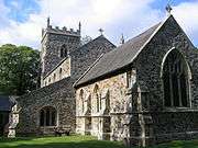
The parish church is a Grade II* listed building dedicated to Saint Helen and dating from the 14th and 15th centuries. The chancel and aisles were rebuilt by Samuel Sanders Teulon in 1866. The church is of greenstone and limestone, with a 15th-century tower, a 14th-century font, and a 19th- to 20th-century interior.[14]
Theddlethorpe Hall or The Hall, is a Grade II listed red-brick country house from the late 17th century, with early 18th- and 19th-century alterations.[15] The Stable Block is also Grade II listed and dates from the 19th century.[16]
Theddlethorpe railway station was a railway station on the Louth and East Coast Railway, opened in 1877, and closed 1960.[17]
| Population of Theddlethorpe St Helens Civil Parish | ||||||||||||||||
|---|---|---|---|---|---|---|---|---|---|---|---|---|---|---|---|---|
| Year | 1801 | 1811 | 1821 | 1831 | 1841 | 1851 | 1881 | 1891 | 1901 | 1911 | 1921 | 1931 | 1951 | 1961 | 2001 | 2011 |
| Population[18] | 220 | 207 | 239 | 275 | 347 | 360 | 414 | 349 | 311 | 281 | 319 | 261 | 312 | 308 | 495 | 525 |
Geography
 |
Skidbrooke, Marshchapel, Grimsby | Saltfleetby, Kilnsea | | |
| Grimoldby, Manby, Louth, Market Rasen | |
|||
| ||||
| | ||||
| Great Carlton, Tothill, Horncastle | Mablethorpe, Sutton on Sea, Mumby | Sandilands, Chapel St Leonards, Skegness |
References
- ↑ "Theddlethorpe Primary School". Theddelthorpe Primary School. Retrieved 15 August 2011.
- ↑ "Theddlethorpe All Saints". Vision of Britain. University of Portsmouth. Retrieved 14 August 2011.
- ↑ "Theddlethorpe All Saints". Neighbourhood Statistics. Office for National Statistics. Retrieved 14 August 2011.
- ↑ "Theddletorpe All Saints population 2011". Retrieved 22 August 2011.
- ↑ Historic England. "Church of All Saints, Theddlethorpe (1062991)". National Heritage List for England. Retrieved 14 August 2011.
- ↑ "Theddlethorpe". Genuki. Retrieved 15 August 2011.
- ↑ "Theddelthorpe Church Reopens". Louth Leader. 20 July 2011. Retrieved 15 August 2011.
- ↑ Historic England. "Hall Farmhouse (1308616)". National Heritage List for England. Retrieved 15 August 2011.
- ↑ Historic England. "Keleshall (355647)". PastScape. Retrieved 15 August 2011.
- ↑ "Vision of Britain". Retrieved 25 August 2011.
- ↑ "Theddlethorpe St Helen". Vision of Britain. University of Portsmouth. Retrieved 14 August 2011.
- ↑ "Theddlethorpe St Helen". Neighbourhood Statistics. Office for National Statistics. Retrieved 14 August 2011.
- ↑ "Theddlethorpe St Helen population 2011". Retrieved 22 August 2015.
- ↑ Historic England. "The Church of St Helen, Theddlethorpe (1147259)". National Heritage List for England. Retrieved 14 August 2011.
- ↑ Historic England. "The Hall, Theddlethorpe St Helen (1147241)". National Heritage List for England. Retrieved 14 August 2011.
- ↑ Historic England. "Stable Block at The Hall (1062993)". National Heritage List for England. Retrieved 14 August 2011.
- ↑ Historic England. "Theddlethorpe railway station (507092)". PastScape. Retrieved 14 August 2011.
- ↑ "Vision of Britain". Retrieved 25 August 2011.
External links
 Media related to Theddlethorpe at Wikimedia Commons
- Theddlethorpe Dunes NNR
- JNNC site
- Theddlethorpe Primary School
England Portal | |
| Unitary authorities | |
| Boroughs or districts | |
| Major settlements |
|
| Topics | |