The Pas
| Town of The Pas | ||
|---|---|---|
|
Welcome sign | ||
| ||
| Motto: Adventure Territory | ||
 Town of The Pas | ||
| Coordinates: 53°49′30″N 101°15′12″W / 53.82500°N 101.25333°WCoordinates: 53°49′30″N 101°15′12″W / 53.82500°N 101.25333°W | ||
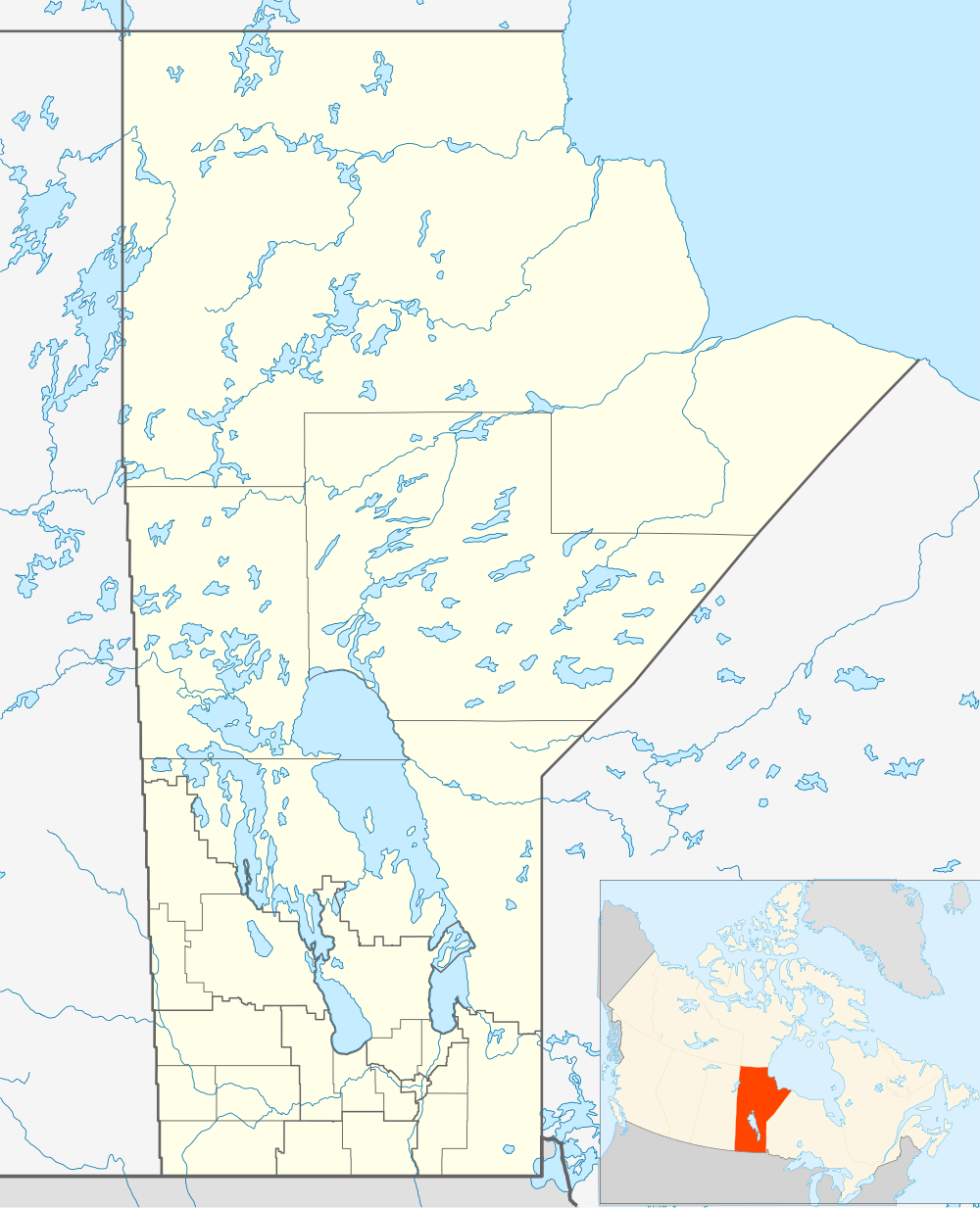
| Country | Canada | |
| Province | Manitoba | |
| Census division | 21 | |
| Region | Northern Region | |
| Incorporated (town) | 1912 | |
| Government | ||
| • Mayor | Jim Scott | |
| Area[1][2] | ||
| • Land | 47.83 km2 (18.47 sq mi) | |
| • Urban | 14.15 km2 (5.46 sq mi) | |
| Elevation | 271 m (889 ft) | |
| Population (2011)[1][2] | ||
| • City | 5,513 | |
| • Density | 115.3/km2 (299/sq mi) | |
| • Urban | 5,689 | |
| • Urban density | 402.1/km2 (1,041/sq mi) | |
| Time zone | CST (UTC−5) | |
| • Summer (DST) | CDT (UTC−6) | |

The Pas (/ðəˈpɑː/; French: Le Pas) is a town in Manitoba, Canada, located at the confluence of the Pasquia River and the Saskatchewan River within Division No. 21 in the Northern Region. It is approximately 630 km (390 mi) northwest of the provincial capital, Winnipeg, and 40 km (25 mi) from the border of Saskatchewan. It is sometimes still called Paskoyac by locals after the first trading post, called Fort Paskoya and constructed during French colonial rule. The Pasquia River begins in the Pasquia Hills in east central Saskatchewan. The French in 1795 knew the river as Basquiau.
Known as "The Gateway to the North", The Pas is a multi-industry northern Manitoba town serving the surrounding region. The main components of the region's economy are agriculture, forestry, commercial fishing, tourism, transportation, and services (especially health and education). The main employer is a paper and lumber mill operated by Tolko Industries. The Pas contains one of the two main campuses of the University College of the North.
The Pas is bordered by the Rural Municipality of Kelsey, as well as part of the Opaskwayak Cree Nation.
History
The area's original inhabitants were the Cree. Their ancestors are thought to have migrated from the southeastern prairies over 9000 years ago.
The first European recorded to encounter the Cree was Henry Kelsey, an employee of the Hudson's Bay Company. He travelled through the area between 1690 and 1692 on his way to the Canadian prairies.
During the years of New France, La Vérendrye, the first western military commander, directed the construction of Fort Paskoya near here. It was named after the people of the Pasquia River. For years the settlement was called Pascoyac, sometimes shortened to Le Pas.
The Pas Indian Band surrendered their reserve lands around the site of the Hudson Bay trading post and the Anglican Church Mission in the first decade of the 20th century to make way for the railroad and development of the Town of The Pas, which was incorporated in 1912. The Pas Indian Band was relocated to the north side of the Saskatchewan River and changed its name to Opaskwayak Cree Nation. The area today is composed of three distinct communities: The Town of The Pas, the Opaskwayak Cree Nation, and the Rural Municipality of Kelsey.
The history of the city and the region may be seen at the Sam Waller Museum, located in the old courthouse in downtown The Pas.
Demographics
| Historical population | ||
|---|---|---|
| Year | Pop. | ±% |
| 1921 | 1,858 | — |
| 1931 | 4,030 | +116.9% |
| 1941 | 3,181 | −21.1% |
| 1951 | 3,376 | +6.1% |
| 1961 | 4,671 | +38.4% |
| 1981 | 6,390 | +36.8% |
| 1986 | 6,283 | −1.7% |
| 1991 | 6,166 | −1.9% |
| 1996 | 5,945 | −3.6% |
| 2001 | 5,795 | −2.5% |
| 2006 | 5,589 | −3.6% |
| 2011 | 5,513 | −1.4% |
| [3][4][5][6][7][1] | ||


The population of The Pas in 2011 was 5,513, while its population density was 115.3 per km².[1] According to the 2011 National Household Survey,[8] the composition of its population was Aboriginals (46.2%): First Nations (26.4%) and Metis (19.8%); and white (51.3%). The visible minority population was 2.1%. The religious make up of The Pas is; Christian (67.2%), non-religious (30.2%), and the remaining 2.6% fall into another religion. Most of the residents are Canadian citizens (99.3%). About 10.3% of the population can speak a language that is not recognized as an official language of Canada. Aboriginal languages are the most common spoken non-official language (5.6%).
The median age in The Pas is 34.1 years old. Age groups are as follows: 9 and younger (16.2%), 10 to 19 (14.7%), 20's (13.6%), 30's (13.6%), 40's (13.1%), 50 to 64 (18.5%), and 65+ (10.2%).
For the peoples ages 24 to 65, the highest levels of education as follows: post-secondary educated (57.0%), high school educated (26.0%) and nothing beyond high school (17.0%). The unemployment rate in The Pas is 7.7%.
Regarding marital status, for those who are 15 and older it goes as follows; married or living with common-law partner (52.9%), never been married (32.3%), divorced or separated (8.8%), or widowed (5.7%).
There are 2,324 private dwellings in The Pas, most of them being occupied (94.1%). The average number of people per household is 2.5 people.
Culture
The Pas was made famous for many young Canadians when author Farley Mowat published in 1956, the first of two children's/young adults' books set in the vicinity and which mentions the town prominently, titled Lost in the Barrens. The story begins at a remote trapping lodge, and then moves the Canadian "barren lands" further north. The Pas is the main trading centre to which the book's protagonists travel to stock up on provisions and supplies to take back to their homes in the bush. In Canada and elsewhere, the book is used as part of school reading, and so despite its size, The Pas is widely known to several generations of Canadians.
Climate
The Pas experiences a Humid continental climate (Köppen Dfb) with long cold winters and short warm summers.
The highest temperature ever recorded in The Pas was 100 °F (37.8 °C) on 19 July 1941.[9] The coldest temperature ever recorded was −57 °F (−49.4 °C) on 18 February 1966.[10]
| Climate data for The Pas Airport, 1981−2010 normals, extremes 1910−present[lower-alpha 1] | |||||||||||||
|---|---|---|---|---|---|---|---|---|---|---|---|---|---|
| Month | Jan | Feb | Mar | Apr | May | Jun | Jul | Aug | Sep | Oct | Nov | Dec | Year |
| Record high °C (°F) | 9.4 (48.9) |
10.6 (51.1) |
15.6 (60.1) |
30.6 (87.1) |
33.9 (93) |
37.6 (99.7) |
37.8 (100) |
35.6 (96.1) |
33.9 (93) |
26.7 (80.1) |
18.4 (65.1) |
8.9 (48) |
37.8 (100) |
| Average high °C (°F) | −14.3 (6.3) |
−10.3 (13.5) |
−2.6 (27.3) |
7.2 (45) |
14.8 (58.6) |
20.8 (69.4) |
23.7 (74.7) |
22.5 (72.5) |
15.7 (60.3) |
7.2 (45) |
−3.8 (25.2) |
−12.0 (10.4) |
5.7 (42.3) |
| Daily mean °C (°F) | −19.1 (−2.4) |
−15.9 (3.4) |
−8.6 (16.5) |
1.3 (34.3) |
8.5 (47.3) |
14.9 (58.8) |
18.1 (64.6) |
16.9 (62.4) |
10.6 (51.1) |
3.1 (37.6) |
−7.4 (18.7) |
−16.4 (2.5) |
0.5 (32.9) |
| Average low °C (°F) | −23.9 (−11) |
−21.3 (−6.3) |
−14.5 (5.9) |
−4.6 (23.7) |
2.2 (36) |
9.0 (48.2) |
12.4 (54.3) |
11.3 (52.3) |
5.6 (42.1) |
−1.0 (30.2) |
−11.0 (12.2) |
−20.8 (−5.4) |
−4.7 (23.5) |
| Record low °C (°F) | −47.8 (−54) |
−49.4 (−56.9) |
−41.7 (−43.1) |
−30.0 (−22) |
−12.8 (9) |
−3.9 (25) |
1.4 (34.5) |
−5.6 (21.9) |
−9.4 (15.1) |
−23.9 (−11) |
−36.1 (−33) |
−46.1 (−51) |
−49.4 (−56.9) |
| Average precipitation mm (inches) | 16.8 (0.661) |
13.4 (0.528) |
17.8 (0.701) |
23.9 (0.941) |
40.1 (1.579) |
66.3 (2.61) |
68.8 (2.709) |
66.5 (2.618) |
57.3 (2.256) |
38.5 (1.516) |
20.9 (0.823) |
19.7 (0.776) |
449.9 (17.713) |
| Average rainfall mm (inches) | 0.2 (0.008) |
0.5 (0.02) |
3.1 (0.122) |
10.1 (0.398) |
36.4 (1.433) |
66.3 (2.61) |
68.8 (2.709) |
66.5 (2.618) |
56.5 (2.224) |
25.4 (1) |
3.1 (0.122) |
0.2 (0.008) |
336.9 (13.264) |
| Average snowfall cm (inches) | 22.8 (8.98) |
18.5 (7.28) |
18.8 (7.4) |
16.0 (6.3) |
3.9 (1.54) |
0.0 (0) |
0.0 (0) |
0.0 (0) |
0.8 (0.31) |
14.5 (5.71) |
23.5 (9.25) |
27.3 (10.75) |
146.1 (57.52) |
| Average precipitation days (≥ 0.2 mm) | 10.7 | 8.6 | 8.3 | 7.3 | 9.4 | 11.0 | 13.3 | 11.8 | 11.3 | 11.0 | 10.5 | 10.6 | 123.8 |
| Average rainy days (≥ 0.2 mm) | 0.27 | 0.37 | 1.2 | 4.1 | 8.6 | 11.0 | 13.3 | 11.8 | 11.1 | 7.6 | 1.4 | 0.38 | 71.0 |
| Average snowy days (≥ 0.2 cm) | 11.8 | 9.2 | 8.1 | 4.3 | 1.2 | 0.07 | 0.0 | 0.0 | 0.33 | 4.6 | 10.7 | 11.7 | 62.0 |
| Mean monthly sunshine hours | 98.8 | 123.2 | 190.3 | 239.4 | 276.5 | 284.5 | 297.8 | 281.3 | 177.7 | 118.9 | 77.7 | 80.4 | 2,246.6 |
| Percent possible sunshine | 39.7 | 44.8 | 51.9 | 57.0 | 55.9 | 55.7 | 58.0 | 61.1 | 46.5 | 36.2 | 30.1 | 34.6 | 47.6 |
| Source: Environment Canada[10][11][12][13][14][15][16][9][17][18][19][20][21][22][23][24][25] | |||||||||||||
Sports
The OCN Blizzard, hockey team, owned by the Opaskwayak Cree Nation, competes in the Manitoba Junior Hockey League. The Pas is also home to the OCN Storm of the Keystone Junior Hockey League, the Huskies minor hockey league, and the MBCI Spartans who compete in Zone 11 of the MHSAA. The Intermediate 'A' version of The Pas Huskies won the 1968-69 Manitoba championship.
The son of former Husky star defenceman Jack Giles, Curt Giles, had a career in the NHL with New York Rangers, St. Louis, and Minnesota. The Pas native Murray Anderson was the first known locally born player to make the NHL, with Washington Capitals in the 1970s. Warren Harrison, younger brother of ex-Husky Roger Harrison, was drafted 53rd overall by the Oakland Seals in the 1969 NHL amateur draft.
The Pas Teepees were baseball champions in the Polar League in 1959. The team included several members of the Huskies, and were inducted into the Manitoba Sports Hall of Fame in 2005.
Government
The Pas is governed by a mayor and six councilors who are elected by residents. The mayor is Jim Scott.
The region is represented in the Legislative Assembly of Manitoba as part of The Pas riding. The riding was held by New Democratic Party (NDP) Member of the Legislative Assembly Oscar Lathlin until his death in November 2008.
In the House of Commons of Canada, The Pas is part of the Churchill riding, held by NDP Member of Parliament Niki Ashton.
Education
The Pas's public school system is the Kelsey School Division, which consists of two elementary schools (Kelsey Community School and Opasquia School), One middle schools (Scott Bateman Middle School), One Alternate program and Adult learning centre (Mary Duncan School) and one high school (Margaret Barbour Collegiate Institute)
There is also a K-6 school (Joe A. Ross) and a junior high/high school (Oscar Lathlin Collegiate) located on the Opaskwayak Cree Nation.
The town hosts the main campus of the University College of the North.
Media
- Radio
- AM 1240: CJAR, adult contemporary
- FM 92.7: CITP-FM, First Nations community radio
- FM 93.7: CKSB-3-FM, Première Chaîne (repeats CKSB Winnipeg)
- FM 94.5: CBWJ-FM, CBC Radio One (repeats CBWK-FM Thompson)
- Television
CBWIT first went on the air in June, 1962 as CBWBT-1. The station broadcast kinescope recordings sent to the transmitter from CBWT. On March 1, 1969, the province-wide microwave system replaced the kinescope recordings, and The Pas has enjoyed live television since then.[26]
All stations serving The Pas are repeaters of Winnipeg-based stations.
Shaw Communications is the local cable television provider serving The Pas, and operates the local Shaw TV channel on cable channel 11.
- Newspapers
- Opasquia Times
See also
References
- 1 2 3 4 "Population and dwelling counts, for Canada, provinces and territories, and census subdivisions (municipalities), 2011 and 2006 censuses (Manitoba)". Statistics Canada. January 7, 2016. Retrieved February 28, 2016.
- 1 2 "Population and dwelling counts, for Canada, provinces and territories, and population centres, 2011 and 2006 censuses (Manitoba)". Statistics Canada. January 7, 2016. Retrieved February 28, 2016.
- ↑ Canada, Statistics (31 March 2008). "Canada Year Book (CYB) Historical Collection". Retrieved 30 May 2016.
- ↑ Canada, Statistics (31 March 2008). "Canada Year Book (CYB) Historical Collection". Retrieved 30 May 2016.
- ↑ Canada, Statistics (31 March 2008). "Canada Year Book (CYB) Historical Collection". Retrieved 30 May 2016.
- ↑ "File not found". Retrieved 30 May 2016.
- ↑ "File not found". Retrieved 30 May 2016.
- ↑ "NHS Profile, The Pas, T, Manitoba, 2011". Statistics Canada. November 27, 2015. Retrieved February 28, 2016.
- 1 2 "Daily Data Report for July 1941". Canadian Climate Data. Environment Canada. Retrieved 21 July 2016.
- 1 2 "The Pas A, Manitoba". Canadian Climate Normals 1981–2010. Environment Canada. Retrieved May 7, 2014.
- ↑ "Daily Data Report for January 1912". Canadian Climate Data. Environment Canada. Retrieved 21 July 2016.
- ↑ "Daily Data Report for February 1932". Canadian Climate Data. Environment Canada. Retrieved 21 July 2016.
- ↑ "Daily Data Report for March 1939". Canadian Climate Data. Environment Canada. Retrieved 21 July 2016.
- ↑ "Daily Data Report for April 1949". Canadian Climate Data. Environment Canada. Retrieved 21 July 2016.
- ↑ "Daily Data Report for May 1936". Canadian Climate Data. Environment Canada. Retrieved 21 July 2016.
- ↑ "Daily Data Report for June 1927". Canadian Climate Data. Environment Canada. Retrieved 21 July 2016.
- ↑ "Daily Data Report for August 1924". Canadian Climate Data. Environment Canada. Retrieved 21 July 2016.
- ↑ "Daily Data Report for August 1940". Canadian Climate Data. Environment Canada. Retrieved 21 July 2016.
- ↑ "Daily Data Report for September 1911". Canadian Climate Data. Environment Canada. Retrieved 21 July 2016.
- ↑ "Daily Data Report for September 1967". Canadian Climate Data. Environment Canada. Retrieved 21 July 2016.
- ↑ "Daily Data Report for October 1939". Canadian Climate Data. Environment Canada. Retrieved 21 July 2016.
- ↑ "Daily Data Report for October 1943". Canadian Climate Data. Environment Canada. Retrieved 21 July 2016.
- ↑ "Daily Data Report for November 1925". Canadian Climate Data. Environment Canada. Retrieved 21 July 2016.
- ↑ "Daily Data Report for December 1911". Canadian Climate Data. Environment Canada. Retrieved 21 July 2016.
- ↑ "Daily Data Report for December 1939". Canadian Climate Data. Environment Canada. Retrieved 21 July 2016.
- ↑ "Microwave Hook-Up Gives North Live TV". Winnipeg Free Press. April 29, 1969. p. 28.
- ↑ Climate data was recorded at The Pas from June 1910 to May 1969 and at The Pas Airport from January 1943 to present.
External links
| Wikimedia Commons has media related to The Pas, Manitoba. |
 |
Flin Flon Cranberry Portage |
| ||
| Nipawin | |
The Pas/Grace Lake Airport | ||
| ||||
| | ||||
| Hudson Bay | Swan River |