Horsforth
| Horsforth | |
 Town Street, Horsforth |
|
 Horsforth |
|
| Population | 18,895 [1] |
|---|---|
| OS grid reference | SE236376 |
| Civil parish | Horsforth |
| Metropolitan borough | City of Leeds |
| Metropolitan county | West Yorkshire |
| Region | Yorkshire and the Humber |
| Country | England |
| Sovereign state | United Kingdom |
| Post town | LEEDS |
| Postcode district | LS18 |
| Dialling code | 0113 |
| Police | West Yorkshire |
| Fire | West Yorkshire |
| Ambulance | Yorkshire |
| EU Parliament | Yorkshire and the Humber |
| UK Parliament | Pudsey |
| Leeds North West | |
Coordinates: 53°50′03″N 1°38′34″W / 53.83413°N 1.64288°W
Horsforth is a town and civil parish within the City of Leeds metropolitan borough, in West Yorkshire, England, lying about five miles north west of Leeds city centre. Historically within the West Riding of Yorkshire, it has a population of 18,895 according to the 2011 Census.[1] Horsforth was considered to have the largest population of any village in the United Kingdom during the latter part of the 19th century. It became part of the City of Leeds metropolitan borough in 1974, and became a civil parish with town council in 1999.
History

Horsforth was recorded in the Domesday Book of 1086 as Horseford, Horseforde, Hoseforde; but late-ninth-century coins with the legend ORSNA FORD and OHSNA FORD may have come from Horsforth. The name derives from Old English hors or, to judge from the coins, *horsa ('horse') in the genitive plural form horsa/horsna + ford 'ford', thus meaning 'horses' ford'.[2] This refers to a river crossing on the River Aire that was subsequently used to transport woollen goods to and from Pudsey, Shipley and Bradford. The original ford was situated off Calverley Lane, but was replaced by a stone footbridge at the turn of the 19th century.
The three unnamed Saxon thegns that held the land at the Conquest gave way to the king who granted it to lesser Norman nobles,[3] but not long after most of the village came under the control of Kirkstall Abbey, a Cistercian house founded in 1152 on the bank of the River Aire downstream of Horsforth.
After the Dissolution of the Monasteries in 1539, Horsforth was partitioned and sold to five families, one of them – the Stanhopes – achieved supremacy and controlled the village for the next 300 years. The estate record of the Stanhopes is regarded as one of the most extensive and important collections of its kind, complementing the extensive medieval record associated with Kirkstall Abbey.
Until the mid 19th century, Horsforth was an agricultural community but it expanded rapidly with the growth of the nearby industrial centre of Leeds. A tannery business was founded at Woodside in about 1820 by the Watson family. It was on the eastern edge of their small farm, and memorialised by Tanhouse Hill Lane. The business became a soap manufacturer and moved to Whitehall Road in Leeds in 1861 and under the chairmanship of Joseph Watson junior, created Baron Manton in 1922, as Joseph Watson & Sons Ltd, became the largest soap supplier to the north east of England, second in size nationally only to Lever Brothers.[4] Industrially, Horsforth has a history of producing high quality stone from its quarries. Not only did it supply Kirkstall Abbey with building materials and millstones in the medieval period, it provided the stone for Scarborough's seafront and sent sandstone from Golden Bank Quarry as far afield as Egypt. Situated on Horsforth Beck (Oil Mill Beck) were mills serving the textile trade.
Between 1861 and 1862, there was an outbreak of typhoid.[5]
Horsforth was historically a township in the parish of Guiseley. It became a separate civil parish in 1866.[6] In the late-19th century it achieved note as the village with the largest population in England. Railways, turnpike roads, tramways and the nearby canal made it a focus for almost all forms of public and commercial transport and it became a dormitory suburb of Leeds. The civil parish became Horsforth Urban District in 1894. The parish and urban district were abolished in 1974 and merged into the new City of Leeds metropolitan district. In 1999 Horsforth became a civil parish and a parish council was created, which exercised its right to declare Horsforth a town.[7]
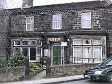
Horsforth Village Museum[8] has collections and displays illustrating aspects of life set against the backdrop of the changing role of the village.
During World War II the £241,000 required to build the corvette HMS Aubretia was raised entirely by the people of Horsforth. In 2000 the US President Bill Clinton acknowledged Horsforth's contribution to the war effort in a letter sent to MP Paul Truswell.[9] The letter is in the museum.
Transport
Rail
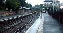
Horsforth railway station is on the Harrogate Line between Harrogate and Leeds. The station is just outside the Horsforth parish boundary, on the Cookridge side of Moseley Beck.
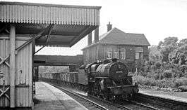
Newlay station, which was built by the Midland Railway, was renamed Newlay & Horsforth station in 1889. It was situated south of the River Aire and was accessible from Horsforth on Pollard Lane which connects Horsforth to Bramley.[10] The station, which was on the Airedale Line (Leeds-Shipley-Skipton), was renamed Newlay station in 1961. It closed on 22 March 1965, along with other stations on the Airedale Line: Armley Canal Road, Kirkstall, Calverley & Rodley and Apperley Bridge.
Bus
The town is served by several bus routes:
- 8 – Pudsey to Cross Gates via Horsforth
- 9 – Seacroft to Holt Park via Rothwell Rodley and Pudsey evenings and Sundays
- 31, 32 – Horsforth Town Circular
- 33, 33A – Leeds city centre to Guiseley/Otley via Kirkstall, New Road Side, Guiseley & Menston
- 50, 50A – Horsforth (The Green) to Seacroft via Burley, Leeds city centre & Harehills
- 97 – Leeds city centre to Guiseley via Headingley, Horsforth & Yeadon
- 757 – Leeds to Otley via New Road Side, Leeds/Bradford Airport
Air
The nearest airport is Leeds Bradford International Airport, in neighbouring Yeadon.
Education
Leeds Trinity University, formerly Leeds Trinity University College, is an independent university after a period as an accredited college of the University of Leeds. The residential campus is located off Brownberrie Lane, Horsforth.
The further education college Leeds City College has a site in Horsforth called the Horsforth Campus. It was previously part of Park Lane College.
The main secondary school is Horsforth School.[11] Horsforth's state sector primary schools are West End Lane Primary School, St Margaret's Primary School, Newlaithes Primary School, Westbrook Lane Primary School, Broadgate Lane Primary School, St Mary's Catholic Primary School and Featherbank Primary School.
Featherbank School opened in 1911 as a primary school, replacing the Grove Day School. The school's infant department was moved to the Grove Methodist Church on Stanhope Drive in 1933, but in 1960 transferred to the Featherbank School annexe. In 1972 Featherbank juniors (7–11 years) were allocated places at the newly built Newlaithes Junior School, at which point Featherbank became purely an infants' school (4–7 years).[12] In September 2011 Featherbank reverted to a full primary school.
There is an independent primary school, The Froebelian School.
Architecture
Horsforth has a large percentage of sandstone buildings sourced from local quarries, more than any other part of Leeds. A draft design statement[13] was produced in 2010, which summarises much of the architectural and historical character.
Churches
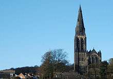
The main churches in Horsforth are;
- Lister Hill Baptist Church[14]
- Cragg Hill Baptist Church[15]
- St Margaret's Church of England[16]
- St James Woodside Church of England[17]
- Kingdom Hall of Jehovah's Witnesses[18]
- Central Methodist Church, Town Street[19]
- Grove Methodist Church[20]
- Woodside Methodist Church[21]
- Willow Green Christian Fellowship Pentecostal[22]
- St Mary's Roman Catholic Church[23]
- Leeds Trinity University campus chapel[24]
- Comboni Missionaries, Brownberrie Lane[25]
Scout and Guide hut
The Scout and Guide hut on New Road Side was requisitioned during the Second World War as an emergency mortuary for the factories based around what is now Leeds Bradford Airport (Yeadon Aerodrome at the time), but it was never needed. Before being purchased by the scouts and guides, the building was used as a cafe, a popular stop off on the way out to Otley, Ilkey and the Dales.
Sports clubs and facilities
- AFC Horsforth; Based at The Old Ball
- AFC Horsforth Junior Club; Trinity and All Saints College.
- Yarnbury Rugby Club
- Horsforth Saints FC
- Horsforth Cricket Club[26]
- Hall Park Cricket Club
- Hall Park Cricket Club is also the home of Horsforth Harriers[27] running club
- Horsforth Golf Club
- Old Ball Football Pitches (Home of Horsforth St Margaret's FC)
- Cragg Hill Football Pitches (Home of Horsforth St Margaret's FC and AFC Horsforth Reserves)
- The Rec FootballPitch (Home of Horsforth Ringway)
- Horsorth School Astroturf (Owned by Horsforth School)
- Horsforth School Football and Rugby Pitches (Owned by Horsforth School and Home of AFC Horsforth Firsts)
- Horsforth Ladies Hockey Club
- West Yorkshire Wolves Junior Rugby League Club
- Horsforth Tennis Club
Nightlife
Given its size, Horsforth has a relatively high number of bars and pubs of varying types from traditional pubs going back to the 17th century to more modern café bars and lounges. Horsforth Town Street has the highest concentration of these with 8 bars and pubs within a short distance of each other. Other popular night life areas include Station Road and New Road Side.[28]
Notable people
- Although originally from London, in the 1970s the former leader of the Labour Party Ed Miliband attended Featherbank Primary School,[29] and his brother David Miliband attended Newlaithes Primary School,[30] when their father Ralph Miliband was a professor at the University of Leeds[31]
- The footballer James Milner who attended Horsforth School and used to play for Leeds United, Newcastle United, Aston Villa and Manchester City. He currently plays for Liverpool and is an English International Footballer.
- The actors Matthew Lewis (Neville Longbottom in the Harry Potter film series), Patric Knowles and Frazer Hines
- The keyboard player Nick Baines, from the Kaiser Chiefs
- The singer Marc Almond, who was educated at Featherbank Primary School until 1968
- David Oxtoby, artist[32]
- Actor Malcolm McDowell, famous for his film roles including If..., A Clockwork Orange and O Lucky Man!.
- Paralympic gold medallist David Stone[33]
- Olympic cycling bronze medallist Jonny Clay[34]
- Sean Conlon who was in the boyband Five, grew up in Horsforth and attended St Mary's RC Primary School.
- BTCC racing driver Sam Tordoff [35]
- Kathryn Apanowicz, a British actress notable for appearing in EastEnders.
- Filmmaker David Nicholas Wilkinson grew up in Horsforth. He is perhaps best known for "The First Film" shot in Leeds
Gallery
 Leeds Country Way close to Horsforth
 Horsforth Millennium Stone
Location grid
 |
Yeadon | | ||
| Rawdon | |
Cookridge | ||
| ||||
| | ||||
| Bramley |
References
- 1 2 "Civil Parish population 2011". Neighbourhood Statistics. Office for National Statistics. Retrieved 27 February 2016.
- ↑ Victor Watts (ed.), The Cambridge Dictionary of English Place-Names Based on the Collections of the English Place-Name Society (Cambridge: Cambridge University Press, 2004), s.v. HORSFORTH.
- ↑ "Horsforth CA" (PDF). Leeds City Council. LCC. 10 November 2008. p. 5. Retrieved 26 November 2015.
- ↑ Wilson, Charles. History of Unilever, London, 1954. Vol.1
- ↑ Epidemiological Society of London, ''Transactions'' (in GoogleBooks). Books.google.com. Retrieved 10 January 2012.
- ↑ Vision of Britain: Horsforth CP
- ↑ "Horsforth Town Council". Retrieved 28 July 2015.
- ↑ "Horsforth Museum, Leeds – Yorkshire". UK Attraction. Archived from the original on 2 March 2012. Retrieved 10 January 2012.
- ↑ "Storm over U-boat film, BBC News, 2 June 2000". BBC News. 2 June 2000. Retrieved 10 January 2012.
- ↑ "Multi Map". Multi Map. Retrieved 10 January 2012.
- ↑ "Horsforth school". Horsforth.leeds.sch.uk. Retrieved 29 July 2015.
- ↑ "school history". Featherbank.leeds.sch.uk. Archived from the original on 27 February 2012. Retrieved 10 January 2012.
- ↑ "Horsforth Design Statement", requires Pdf download. Retrieved 10 January 2012
- ↑ "Lister Hill Baptist Church". Listerhill.org.uk. Retrieved 10 January 2012.
- ↑ "Cragg Hill Congregation". South Parade Baptist Church. Retrieved 10 January 2012.
- ↑ "St Margaret's Church Horsforth". Stmargaretshorsforth.org.uk. Retrieved 10 January 2012.
- ↑ "St James, Woodside". Stjameswoodside.org. Retrieved 10 January 2012.
- ↑ "The Kingdom Hall of Jehovah's Witnesses, Calverley Lane, Horsforth", GENUKI.org.uk. Retrieved 10 January 2012
- ↑ "Central Methodist Church, Town Street, Horsforth, Leeds", Geograph.org.uk. Retrieved 10 January 2012
- ↑ "Grove Methodist Church, Horsforth, Leeds". Grovemethodist.org.uk. 6 January 2012. Retrieved 10 January 2012.
- ↑ Thomson, Richard; "Woodside Methodist Church, Outwood Lane, Horsforth, Leeds", Genuki.org.uk. Retrieved 10 January 2012
- ↑ Horsforth Churches Together, Grovemethodist.org.uk. Retrieved 10 January 2012
- ↑ "St Mary's Roman Catholic Church, Horsforth", Genuki.org.uk. Retrieved 10 January 2012
- ↑ "History of the Chapel", Leedstrinity.ac.uk. Retrieved 10 January 2012
- ↑ Comboni Missionaries, Comboni.org.uk. Retrieved 10 January 2012
- ↑ Taylor, Chris. "Horsforth Cricket Club". Pitchero.com. Retrieved 10 January 2012.
- ↑ "Horsforth Harriers Running Club". Horsforthharriers.co.uk. Retrieved 10 January 2012.
- ↑ http://pubsinhorsforth.co.uk/
- ↑ "'Once a Featherbanker...' Ed Miliband returns to the Horsforth school that fostered his love of Leeds United", Yorkshire Post, 14 October 2011. Retrieved 27 June 2012
- ↑ McIntyre, Annette ". . . and that he would never be a professional footballer", Telegraph & Argus, 24 June 2010. Retrieved 10 January 2012
- ↑ "Ralph Miliband biography, London School of Economics website". Lse.ac.uk. 24 November 2010. Archived from the original on 27 May 2010. Retrieved 10 January 2012.
- ↑ "David Oxtoby" Redfern Gallery. Retrieved 10 January 2012
- ↑ 1 (17 September 2008). "Dave Stone: Horsforth cyclist wins second Paralympics gold – Sport – Yorkshire Evening Post". Horsforthtoday.co.uk. Retrieved 10 January 2012.
- ↑ 2 (27 August 2008). "Jonny Clay in Horsforth Today". Horsforthtoday.co.uk. Retrieved 10 January 2012.
- ↑ http://www.yorkshireeveningpost.co.uk/sport/other-sport/motorsport-tordoff-confident-of-being-in-the-touring-car-title-race-1-6440469
External links
| Wikimedia Commons has media related to Horsforth. |
- Horsforth Town council website
- Horsforth Today Online Newspaper
- Horsforth school website
- YEP Horsforth Today Community Website
- Horsforth Town Council website
- Horsforth Community website
- The ancient parish of Guiseley: historical and genealogical information at GENUKI (Horsforth was in this parish).
- Lister Hill Baptist Church site