The Centre, Bristol
| The Centre | |
|---|---|
|
The Centre, Bristol | |
 The Centre | |
| OS grid reference | ST586730 |
| Coordinates | 51°27′09″N 2°36′05″W / 51.4526°N 2.6015°W |

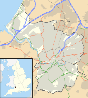
The Centre is a partially pedestrianised public open space in the central area of Bristol, England, created by covering over the River Frome.[1] The northern end of The Centre is a paved area circuited by Colston Avenue; the southern end is separated from this by a major road junction and is a larger paved area bounded by St Augustine's Parade to the west, Broad Quay the east, and St Augustine's Reach (part of the Floating Harbour) to the south. The Centre is managed by Bristol City Council.[2]
The name 'The Centre' (or 'The City Centre') appears to have been applied to the area from the mid-twentieth century; in the first half of the twentieth century it was known as the Tramways Centre,[3] and before the Tramways Centre island was built it was known as 'The Drawbridge'.[4]
The Centre is not the historic or civic centre of Bristol, nor is it the major shopping area. It is however an important local transport interchange and meeting place.[5] Many local bus services terminate at or pass through here,[6] and it is also served by ferry services to Hotwells and Temple Meads station,[7] and has busy taxi ranks.
The Centre has been altered on a number of occasions, originally to ease traffic flow[8][9] but latterly to try to strike a balance between its use as both public open space and an important traffic corridor.[10] Proposals are currently being developed for another remodelling.[11]
History
Before the culvert
The Centre owes its form to the channel dug in the 1240s to provide additional quays and wharves for the burgeoning Bristol Docks.
This channel, St Augustine's Reach, became the heart of Bristol Docks. As trade flourished and ships became larger the docks expanded, but the completion of the Floating Harbour in 1809,[12] and the building of docks at Avonmouth and Portishead made the wharves at the northern end of St Augustine's Reach increasingly marginal.
The northern end of St Augustine's Reach was narrower and accessed by opening The Drawbridge, which crossed the docks at the end of Clare Street (where present-day Baldwin Street was built in 1881). The Drawbridge was rebuilt for the fourth and final time in 1868, but by 1893 when it was replaced by a fixed structure it had been a source of "great congestion" to traffic (including the new trams) for many years,[3] often being left open for twenty minutes while ships were roped up.[13]
Magpie Park
In 1892 The Drawbridge was replaced by the elegant stone St Augustine's Bridge; at the same time the docks to the north were infilled. The new area, which was called Magpie Park, was enclosed by Colston Avenue.[14] It was named after the The Bristol Magpie newspaper, whose offices were located on the western side of Colston Avenue.[15] The Bristol Industrial and Fine Arts Exhibition was held here in 1893; a popular attraction which saw 500,000 attendees and raised £2200 for charity.[4]
This is now the site of Bristol's Cenotaph. Unveiled in 1932,[16] The Cenotaph continues to be the focus of local remembrance.[17]
Tramways Centre
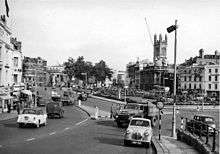
During the 1890s Bristol's tramway system was expanded and electrified. In 1895 the Bristol Tramways and Carriage Company (BT&CC) moved their head office to premises at 1–3 St Augustine's Parade (where they remained until 1970).[5] The need for a central interchange was recognised and to this end a large triangular traffic island, later nicknamed 'Skivvy's Island' because of its use by domestic servants,[18] was built between the BT&CC offices and St Augustine's Bridge.[4] The Tramways Centre became the most important of the BT&CC's three central termini, serving more routes than the others at Bristol Bridge and Old Market.[19] It was the terminus for trams from the north and east of the city, and trams from Hotwells to Temple Meads and Brislington also stopped here. Passengers could straightforwardly alight from one tram and board another to continue their journey without the need to cross roads. A large three-faced ornamental clock was fixed high on the Tramways offices, and 'under the clock on The Centre' became a popular meeting place.[5][20]
J.B Priestley visited Bristol in 1933, and described The Centre as 'a place where trams and coastal steamers seemed in danger of collision'.[21]
Buses first started to use the Tramways Centre in 1910,[22] initially only on the route to Clifton.[19] By 1913, ten bus routes started from The Centre.[23] In 1938 and 1939 the tram routes serving the Tramways Centre were replaced by buses,[24] so that trams ceased to use the island. Trams elsewhere in the city ceased completely in 1941.[3]
Inner Circuit Road
In 1938 construction started on a culvert covering the area between St Augustine's Bridge and the southern end of Broad Quay.[25] This created a route for the Inner Circuit Road, which had already bisected Queen Square, to continue northwards. Construction continued despite the outbreak of war. A large elongated roundabout was formed, with the central space initially being used as a car park. The Tramways Centre island was reshaped, and was no longer used as a transport interchange.[8]
After the war the central space was planted with lawns, ornamental borders and golden Irish yews and became known as the Centre Gardens.[8]
1957 remodelling
The Inner Circuit Road was extended northwards into Colston Avenue in 1957–58. The Tramways Centre island was removed and the Centre Gardens island was extended to a point near the end of St Stephen's Street. Magpie Park was reduced in length, Colston Avenue was widened and many of the (by then) mature plane trees were felled.[9]
1998 remodelling
It had been recognised since the 1960s that the southern half of the Inner Circuit Road had badly impacted the amenity of Queen Square and The Centre,[26] and by the 1990s tentative steps were being taken towards downgrading this part of the road and transferring traffic along less sensitive routes. By the mid-1990s, the road across Queen Square had been closed and plans were being developed to rebalance The Centre in favour of pedestrians and public transport.
Bristol City Council launched a consultation exercise in 1996, in which the public were asked to choose between a 'Dock Option' (reopening the old harbour as far as St Augustine's Bridge) and a cheaper 'Promenade Option'. Both options involved closing the road across Quay Head; the Promenade Option used the new space to create a larger pedestrianised area in place of the Centre Gardens, with fountains, a cascade leading down to the waterside, and a sail structure to evoke Bristol's maritime past. The remaining road space in both options would be designed to give greater priority to public transport.[10]
The Council decided to build the 'Promenade Option'. This soon came under criticism for its poor safety, particularly after a number of pedestrians were injured by vehicles and at least two people struck by buses and killed.[27] The new design was also criticised for its traffic noise and fumes, "dribbling" fountains, poor traffic flow, poor cycling infrastructure, and delays to public transport.[28] Few were happy with the new design, and many were disappointed that the 'Dock Option' had not been pursued.[28]
The area around the pedestrian crossing at the Baldwin Street end of Broad Quay was altered in 2003 after the Bristol Coroner called for improvements.[29]
Despite remedial work in 2007, the sail structure was found to be unsafe and removed in 2009.[30]
In 2011 plans were again being developed for major changes to The Centre. These plans include the possibility of prohibiting private vehicles from crossing The Centre on the east-west axis, as mooted in the 1996 consultation.[10][27]
2015 remodelling for MetroBus
._Works_commence_on_extending_Baldwin_St_towards_St_Augustine's_Parade.jpg)
Work began in September 2015 on an £8 million project to change the layout of The Centre once more, this time to accommodate the MetroBus bus rapid transit scheme.[31]
Planned alterations include:
- Improved public spaces, including a reduction in traffic around the Cenotaph;
- A new link between Baldwin Street and St Augustine’s Parade, approximately on the site of St Augustine's Bridge;
- New segregated paths for cyclists;
- Relocated taxi ranks;
- New bus stops for MetroBus services,
- Additional changes to traffic routes around The Centre.[32]
Sites of interest
As well as the Cenotaph, Magpie Park has statues of Edmund Burke (1894) and Edward Colston (1895). St Mary on the Quay stands on Colston Avenue to the west of the park, and St Stephen's Church stands nearby to the east.
The southern end of The Centre (the Centre Promenade) has a lead statue of Neptune, moved to The Centre from Temple Street in 1949,[33] and a modern water feature with fountains. Another water feature, this one stepped, leads down to a ferry landing stage at the current head of St Augustine's Reach. There is a busy taxi rank opposite the end of Baldwin Street.
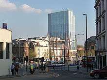
The Hippodrome stands to the west of the Centre Promenade on St Augustine's Parade. Further north is the Colston Tower and just west of this on Colston Street is the Colston Hall.
On Broad Quay, the former head office tower of the Bristol and West Building Society has recently been refurbished as a hotel[34] and serviced flats.[35]
References
- ↑ "The City Centre. Or is it?". About Bristol. Retrieved 20 February 2011.
- ↑ "City Spaces – Centre Promenade". Bristol City Council. Retrieved 17 February 2011.
- 1 2 3 Appleby, John B (1969). Bristol's Trams Remembered. J.B. Appleby.
- 1 2 3 Winstone, Reece (1983). Bristol as it Was 1845–1900. Reece Winstone. ISBN 978-0-900814-00-6.
- 1 2 3 Appleby, Butcher, Gailey, Hulin, Mathieson, Urwin, Robinson, Rootham and Wellman (1974). The People's Carriage 1974-1974. Bristol Omnibus Company Ltd.
- ↑ "Bus Departure Information (Bus shelter poster)". Bristol City Council. Retrieved 17 February 2011.
- ↑ "Ferry Map". Bristol Ferry Boat Co. Retrieved 17 February 2011.
- 1 2 3 Winstone, Reece (1980). Bristol in the 1940s (3rd Edition). Reece Winstone. ISBN 0-900814-61-6.
- 1 2 Winstone, Reece (1972). Bristol as it Was 1956–1959. Reece Winstone. ISBN 0-900814-39-X.
- 1 2 3 Creating a new Centre for Bristol (leaflet), Bristol City Council, 1996
- ↑ "Bristol transport supremo's vision for remodelled Centre". Bristol Evening Post. Retrieved 17 February 2011.
- ↑ Little, Bryan (1991). The Story of Bristol From the Middle Ages to Today. Redcliffe Press Ltd. ISBN 1-872971-40-7.
- ↑ Winstone, Reece (1978). Bristol in the 1880s (2nd edition). Reece Winstone. p. 23. ISBN 978-0-900814-55-6.
- ↑ "Bristol's Fascinating Fountains" (PDF). Temple Local History Group. Retrieved 17 February 2011.
- ↑ Winstone, Reece (1973). Bristol in the 1890s. Reece Winstone. p. 9. ISBN 0-900814-42-X.
- ↑ Winstone, Reece (1979). Bristol as it Was 1928–1933. Reece Winstone. ISBN 0-900814-57-8.
- ↑ "Remembrance Day parades and services across greater Bristol area". Bristol Evening Post. Retrieved 17 February 2011.
- ↑ Winstone, Reece (1977). Bristol in the 1920s. Reece Winstone. ISBN 0-900814-50-0.
- 1 2 "BT&CC tram map, 1911". Bristol Vintage Bus Group. Retrieved 2 March 2011.
- ↑ "Britain at War: Devastated by friend's death". Daily Telegraph. Retrieved 20 February 2011.
- ↑ Priestley, J.B. (1934). English Journey. Mandarin. ISBN 978-0-7493-1924-3.
- ↑ Hulin, P (1974). Bristol's Buses. Published by the author. p. 3. ISBN 0-9503889-0-4.
- ↑ Hulin, P (1974). Bristol's Buses. Published by the author. p. 4. ISBN 0-9503889-0-4.
- ↑ Hulin, P (1974). Bristol's Buses. Published by the author. p. 9. ISBN 0-9503889-0-4.
- ↑ Winstone, Reece (1978). Bristol as it Was 1939–1914 (5th Edition). Reece Winstone. ISBN 0-900814-54-3.
- ↑ City centre policy report and map 1966. City and County of Bristol. City of Bristol Printing and Stationery Department. 1966.
- 1 2 "Is it time to drive cars out of Bristol City Centre? Bristol's traffic supremo believes so". Bristol Evening Post. Retrieved 19 February 2011.
- 1 2 "Bristol Central Area Action Plan: Cherish & Change summary". Bristol City Council. 26 July 2010. Retrieved 19 February 2011.
- ↑ "Bristol centre to be revamped". BBC News. 15 May 2003. Retrieved 18 February 2011.
- ↑ "Bristol city centre landmark has wind taken out of its sails". Bristol Evening Post. Retrieved 19 February 2011.
- ↑ "Bus stop changes on Bristol's Centre mark the start of £8m remodelling scheme". Bristol Post. Retrieved 11 September 2015.
- ↑ "City Centre Improvements". travelwest. Retrieved 6 October 2015.
- ↑ "Statues and Sculptures – Introduction". About Bristol. Retrieved 18 February 2011.
- ↑ "From eyesore to Bristol icon". Bristol Evening Post. Retrieved 18 February 2011.
- ↑ "Broad Quay Serviced Apartments, Bristol". activehotels. Retrieved 18 February 2011.
External links
![]() Media related to The Centre, Bristol at Wikimedia Commons
Media related to The Centre, Bristol at Wikimedia Commons