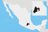
Tequixquiac
| Tequixquiac | |||
|---|---|---|---|
| Municipality | |||
|
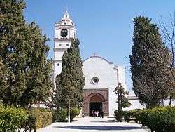
Church of Saint James Apostle in Tequixquiac | |||
| |||
 | |||
| Coordinates: 19°54′34″N 99°08′41″W / 19.90944°N 99.14472°WCoordinates: 19°54′34″N 99°08′41″W / 19.90944°N 99.14472°W | |||
| Country |
| ||
| State | State of Mexico | ||
| Region | Zumpango Region | ||
| Municipal seat | Santiago Tequixquiac | ||
| Founded | 1168 | ||
| Municipal Status | 1820 | ||
| Government | |||
| • Municipal President | Salvador Raúl Vásquez Valencia (2016-) | ||
| Elevation (of seat) | 2,200 m (7,200 ft) | ||
| Population (2010) | |||
| • Municipality | 33,907 | ||
| • Seat | 20,610 | ||
| Time zone | CST (UTC-6) | ||
| Postal code (of seat) | 55650 | ||
| Website | (Spanish) http://www.tequixquiac.gob.mx/ | ||


Tequixquiac is the municipality located in Zumpango Region, the northeastern part of the state of Mexico in Mexico, the municipal seat is Santiago Tequixquiac, although both are commonly called only Tequixquiac. The municipality is located at a northern pass leading out of the Valley of Mexico and Mezquital Valley to 84 kilometers north of Mexico City and about 280 km northeast of the state capital of Toluca. The name comes from Nahuatl and means "place of tequesquite waters".[1]
This municipality is knew as Prehistoric art cradle in the Americas by sacrum bone vestige and the fossil material found in this place,[2] also has got a chronology of interesting events in the municipal history.
Geography
The location of the municipality is northem of the state of Mexico, and is located in the low extreme geographical coordinates of Greenwich, north latitude 19º50'23" minimum, 19º58'28" maximum, west longitude 99°04'30" minimum, 99°13'35" maximum.[3]
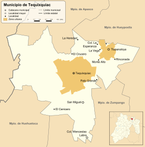
The town of Santiago Tequixquiac, a municipal seat, has governing jurisdiction over the following communities: La Heredad, San Miguel, Tlapanaloya, El Cenicero, Colonia Wenceslao Labra, Colonia La Esperanza, Palo Grande, Monte Alto, El Crucero, La Arenilla, La Rinconada and La Vega.[4] The total municipality extends 96.37 and borders with the municipalities of Apaxco, Hueypoxtla, Zumpango, Huehuetoca and the state of Hidalgo.
The Gran Canal de Desagüe is an artificial channel that crossing Tequixquiac, was named Xothé river in otomi language, this channel connect with Tula river and Enthó dam. Other small river is Río Salado of Hueypoxtla, Treviño river and La Pila river, connect with Gran Canal.[3]
The municipal seat is in a small, elongated valley but most of the municipality is on a high mesa which transitions from the Valley of Mexico to the Mezquital Valley.[1] The highest mountain in Tequixquiac is the Cerro Mesa Ahumada, it rises 2,600 metres (8,500 ft) above sea level,[5] on the border between the municipalities of Huehuetoca and Apaxco.
Flora and fauna

Tequixquiac municipality is a rural territory of Central Mexican Plateau, here there is a diversity in plants and animals of template climate (Mexico Valley) and semi-desertic climate (Mezquital Valley).[6] Inside this municipality, formerly it was populated by large mammals such as glyptodonts, mammoths, horses, bisons, during the prehistoric, at the stage of the population of the Americas.[7]
The native plants are maguey (agave americana), cardón or cholla (cylindropuntia imbricata), nopal or pickly pear (opuntia ficus-indica), viznaga or golden barrel (echinocactus), órgano or fencepost cactus (pachycereus marginatus), garambullo or billberry cactus (myrtillocactus geometrizans), palo dulce (eysenhardtia polystachya), mesquite (prosopis juliflora), ahuehuete (taxodium mucronatum), encino or netleaf oak (quercus rugosa), tepozán (buddleja cordata), huizache (vachellia farnesiana), cedro or white cedar (cupressus lusitanica), sause or willow (salix), xaixne or creosote bush (larrea tridentata), dingandán or pepicha (porophyllum linaria), depe or creeping false holly (Jaltomata procumbens), tule (schoenoplectus acutus), carrizo (phragmites communis), and fruit trees as tejocote (crataegus mexicana), capulin (prunus serotina), white sapote (casimiroa edulis).
The native animals are cacomistle, skunk, gopher, Virginia opossum, rabbit, Mexican gray squirrel, turkey, colibri, turkey vulture, northern mockingbird, rattlesnake, pine snake, xincoyote, red warbler, rufous-crowned sparrow, lesser roadrunner, great horned owl, axolotl, frog, toad, red ant, bee, others.
Ecology & environment


Tequixquiac is one of the State of Mexico's municipalities with low impact to the environment, people have denied any proposed Municipal Plan for Urban Development not to be victims of footloose capital speculators or in collusion with public officials.[8] The town is a large pool of rain water catchment for the Valley of Mexico, having no contaminating the soil industry remains undisturbed by the hand of man, the hills are protected from being undermined by construction materials companies.
The people have an attachment to the land and the natural environment, are semi-rural behavior by its proximity to the Mexico City metropolitan area, Cerro Mesa Ahumada is a well-preserved natural area that you can still enjoy their areas and also has many species of flora and fauna that is no longer possible to see in other neighbor municipalities.[9]
In addition, Tequixquiac is one of the metropolitan municipalities of Mexico City where the footprint is moderate and the impact of industrial and urban human activities is lower than in other municipalities in the state or shares quines neighborhood. However, a major environmental problem that has suffered the township is over Tequixquiac tunnel open, a great work of the government of former president Porfirio Díaz, the tunnel has been a focus of infection and the amount of waste gases given off by sewage from residential, commercial, industrial and hospital areas of Mexico City.
Tunnel of Tequixquiac causes debate among the locals, the Comición Nacional del Agua and different levels of government, if it continues the extension of the tunnel on the river Xothé (Great Channel) would be million-dollar of water in the area and that seems contradictory but wastewater are the ones who keep the fields green and the area also filtering the water is decanted into the ground and a number of underground streams vital to the ecological balance of the area, if you cancel the water suminstro black for agricultural use would grow ambisiosa speculation and force the ejidatarios to sell their land for housing developments and ecological desatre descadenaría a great impact on the country, since this region and others in the Midwest buffer areas rain water filtration for not disproportionately urban land and regulate the temperature of the Valley of Mexico.
Within the municipality there are environmental groups seeking to improve the natural environment through environmental campaigns of reforestation, garbage collection and recycling, information workshops for uses of wastewater and protection against forest fires. These groups highlighted Acatlán AC, Granito de Arena AC.
History

A sacrum bone found in Tequixquiac is considered a work of prehistoric art. The first indigenous settlers of Tequixquiac were the Aztecs and Otomi, who decided to settle here permanently for the abundance of rivers and springs. They were engaged mainly in agriculture and the breeding of domestic animals.
In 1152, the Aztecs, on their way to the Valley of Mexico from Tula-Xicocotitlan to Tequixquiac, decided to settle for a short time at a place called Tepetongo. This land is named Teotlalpan Province by Tepanecs tribe.
In 1168, the village of Tequixquiac was founded, which had approximately 250 houses scattered the length and breadth of the nearby hills. Tequixquiac village was conquered by the Aztecs under the rule of Emperor Chimalpopoca.

During colonialization after the fall of Tenochtitlan, Hernán Cortés rewarded his soldiers with parcels of land and one of them was Tequixquiac which was given to two Spaniards: one of whom was Martín López, builder of the launches in taking Tenochtitlan, and the other Andrés Núñez was being split in two, their children inherited after their death. Tequixquiac Corregimiento Zitlatepec belonged at this time the Viceroy Luis de Velasco to regulation mandates the protection of indigenous people.
In the territory of Tequixquiac, Apaxco and Hueypoxtla had deposits of limestone, and through grants awarded to the Spanish introduced a thriving industry using Indian labor, decimating the population in conditions of extreme poverty and forced labor.
They gathered the dispersed families tlaxcaltecas Francisco Lopez de Tlaltzintlale by the year 1552 to strip them of their land and these were distributed through grants to Spanish real.

The Spanish empire sought to justify their acts through the Christian Missions. The Franciscans arrived in New Spain in 1524, but clerics arrived even before that to proselytize to the Indians, building a chapel in each encomienda.
With the help of the Franciscan friars, the temple of Saint James the Apostle was built, raising Tequixquiac from vicarage rank to parish. The Church of Santiago Tequixquiac became a parish in 1590. The construction of the building was carried out at different stages; the parish was a large atrium space with a cross in the center of carved stone, with indigenous and Christian symbols in the four corner chapels in the pits and an open chapel with beautiful columns on the facade and two extraordinary stone-carved jambs by Indian hands who left part of his philosophy embodied in them. The temple was dedicated to Santiago Apostol, because some families Galicia, Asturias Andalusia and Leon were in the region.
At the beginning of the political jurisdiction of Tequixquiac covered the current territory of Tlapanaloya without the people to be integrated into the eighteenth century. For some time I add Apaxco because it did not for an economic infraestrctura jurisdiction. During the independence movement came to the news by Tequixquiac dances and arrieria as the media. Tequixquiac was among the first peoples of that province was constituted as a municipality on November 29, 1820 by joining the independence of Mexico on the basis of the Constitution of Cadiz.
Bando Municipal For the December 17, 1823, he published Tequixquiac the form of government that would govern the country. 'Mexican nation adopts for its government as representative of People's Federal Republic,' published in the same way the oath to the Constitution of the United Mexican States in October 1824.
By Decree No. 41 of April 8, 1825, was added to Zumpango: Hueypoxtla and Tequixquiac belonging andalusia Tetepango party, based on the law at the same time, the prefect of Tula and separates Tequixquiac haciendas de Tena and corners of the municipality of Guadalupe Atitalaquia.
.JPG)
Texquixquiac was one of the first town to become a municipality under the provisions of the Cadiz Constitution, before the end of the Mexican War of Independence: becoming so on 29 November 1820.
The Grand Canal was built through here during the presidency of Porfirio Díaz in order the drain the Valley of Mexico, was built in second phase by British company signed as Mexican Prospecting and Finance Co Ltd. y la Read & Campbell in 1867,[10] the workers stay in campament around the Hacienda of Acatlan in El Tajo de Tequixquiac.[11] During its construction many of the archeological finds telling of the early existence of humans in this area were found. One of the engineers of the canal project, Tito Rosas, is credited with finding the "Sacro de Tequixquiac".
During the Mexican Revolution, General Emiliano Zapata arrived to Tequixquiac and redistributed the lands of the municipality. Approximately 275 hectares of land was redistributed under the ejido system. Another 3,338 hectares was awarded as ejido land by President Emilio Portes Gil. A system to irrigate these lands was sponsored by President Lázaro Cárdenas between 1937 and 1938, installing a pump to take water out of the drainage canal to irrigate lands here.[1]
.jpg)
Another drainage canal for the Valley of Mexico was built through here in 1954 under the presidency of Adolfo Ruiz Cortines. This spurred economic development of the municipality by increasing the amount of cultivable land. The construction of a highway connecting the municipality to Zumpango, Apaxco and the state of Hidalgo helped it to reach new markets.[1]
Communication and transport

Two state roads cross through the municipality, linking it with Zumpango-Apaxco number 9 a way that connect with Mexico City and Atitalaquia in State of Hidalgo, other municipal road connect with Tlapanaloya, Hueypoxtla and Arco Norte highway; finally, Tequixquiac municipality has got other road at west, Huehuetoca-Apaxco number 6, a road with connection to Tula-Jorobas highway. Three rail lines pass through: one linking Mexico City, Pachuca and Querétaro. There is no main bus station, the principal destinies are Indios Verdes, Martín Carrera and Cuatro Caminos subway stations in Mexico City, for public transport to Hueypoxtla, Zumpango and Apaxco, other destinies are Ecatepec de Morelos, Tlahuelilpan Main bus station, International Airport of Mexico City, and Tepotzotlán Main bus station. Tequixquiac hasn't got connection with public transport to Toluca de Lerdo, only there is two routes connect to the state capital, Metro Observatorio bus station in Mexico City and Naucalpan de Juarez (Primero de Mayo bus station).[12]
The telephone code is 591+ for Santiago Tequixquiac and Colony Wenceslao Labra and telephone code 599+ for Tlapanaloya town,[13] all municipality is communicated with telephone web.
Politics

| Mayor | Time |
|---|---|
| Adrían Rojas Hernández | 1995-1997 |
| Emiliano Cruz Rodríguez | 1997-2000 |
| José Rafael Pérez Martínez | 2000-2003 |
| Gustavo Alonso Donís García | 2003-2006 |
| Enrique Martínez Astorga | 2006-2009 |
| Xóchitl Ramírez Ramírez | 2009–2012 |
| Juan Carlos González García | 2012–2015 |
| Salvador Raúl Vásquez Valencia | 2016– |
Tequixquiac municipality has a town hall, which is administered by a municipal president or mayor, a treasurer, a municipal secretary and councilors; the municipal seat is Santiago Tequixquiac town. This municipality has got a Municipal public announcement of police side and good governance (Bando municipal de policía y buen gobierno), are local laws, this issued each year and published every February 5, the national Constitution Day.
Tequixquiac is dissected politically in two towns (Santiago Tequixquiac and Tlapanaloya), neighborhoods, agricola colonies, and rancherías.[14]
Economy

Tequixquiac was recognized by production of calcium oxide during Aztec empire when otomi people paid tribute in Hueypoxtla province, the calcium oxide was used by construction and nixtamal, then Spaniards continued with production of calcium oxide in this region named Teotlalpan, as a tribute by construction.[12] During century XIX was recognized Tequixquiac also by corn agriculture and pulque production inside their haciendas, this beverage was transported to Mexico City on donkeys or mules.
The municipality's economy has traditionally been based in agriculture, especially in the growing of corn, alfalfa, tomato, wheat, chili and bean, mostly used for auto-consumption. However, climatic change has diminished harvests and the growth of commerce in the form of small and medium-sized businesses have grown. Industry here is minimal, only agro-industry in milk and forage; in Tequixquiac make cheese, cream, butter, tostadas and handcraft beer.[1]
Little opportunities and unemployment within the municipality, has led to the departure of building Tequixquiac workers to other Mexican cities and other countries; the tradition of masonry, is recognized in construction of buildings and industry, has been developed as a source of employment in this region, is a working very hard and dangerous but with good paying, also hiring people in manufacturing and build welding of branches, cones and pipes, construction in refractory horns, chimneys, channels, vault walls for cement plants, glass factories, and steel mills calcining.[12]
Demography
| Town | Population |
| Total | 31,080 |
| Santiago Tequixquiac | 19,772 |
| Tlapanaloya | 6,294 |
| Wenceslao Labra | 1,248 |
At the census of 2010, there were 33,907 people, The population density was 155.4 people per square mile (96.37/km²), The median age was twenty-four years. For every 17,113 females there were 16,794 males.[15]
Languages
| 2000 language groups[16] | |
|---|---|
| Languages | Population |
| Total | 398 |
| Otomi language | 106 |
| Mazahua language | 55 |
| Other languages | 237 |
In Tequixquiac the first language spoken is Spanish, it's mother language for the mayority, in 2005 only 189 persons speak other language[17] as soon as 398 persons speak an indigenous language in this municipality; the second language is Otomi, in Santiago Tequixquiac there are otomi toponyms as Taxdho, Vije and Bomitza (Gumisha), this land was inhabited, before and Spanish colonization, by Otomis and Aztecs, also named Chichimeca people. Other languages spoken in Tequixquiac are Mazahua, Nahuatl, Mixtec, Zapotec, Purepecha and Huastec, this languages are spoken by indigenous immigrants to this municipality. The migration to United States of America and elementary education, is introduced English language in the children and teens, but it is not possible to know how many people speak this language.
Religion
The predominant religion is Catholic Christianity have a 90% of the total population of the municipality in 16 796 as in 1990, there is a parish belonging to the Diocese of Cuautitlan, as well as a chapel in each neighborhood, district or ranch the second growing religious community is that of Jehovah's Witnesses have a Kingdom Hall located in the suburb of San Mateo and acceptance this denomination has spread rapidly throughout the whole town, the rest are Protestant communities of various denominations as evangelicals, Pentecostals, Methodists, Mormons, Only Christians, and Adventists cornerstone.[18]
In Tequixquiac there is the presence of Judaism since the Spanish colonial period to the present, the few believers are descendants of Spanish and Portuguese Sephardic people; majorly of these Crypto-Jews or marranos were absorbed by Roman Catholicism.[1] Another group of people claim not to believe in God and consider themselves atheists, mostly they are young; Atheists are on the rise in recent years.
| Religion | Population (1970) | Population (1990) |
| Total | 10,276 | 17,995 |
| Roman Catholic | 9,872 | 16,796 |
| Protestantism | 314 | 662 |
| Atheism | 71 | 275 |
| Judaism | 7 | 11 |
| Others | 12 | 202 |
| No specific | -- | 49 |
Health
Tequixquiac municipality has got with 4 public clinics of health of ISEM in San Mateo, San José, Colonia Adolfo López Mateos and Tlapanaloya town. The principal cases of death are diabetes mellitus, hypertension, cancer and crib death, other disease are kidney infections and respiratory problems, this unities serve these diseases and guide to prevent.[19] The service in public hospitals is attendant in Apaxco, Zumpango and Tecamac municipalities, in Santiago Tequixquiac there are two privated hospitals, they are serving mainly births and chronic diseases.
Culture
Folklore
.JPG)


The Contradanza de las Varas is a traditional creole dance that is performed in the town celebrations of Santiago Tequixquiac and Tlapanaloya, not based on indigenous dances.[20][21]
The Holy Week is a cultural celebration of Tequixquiac and Tlapanaloya towns, start with Palm Sunday, is manifested on processions with colonial sculptures, chants and prays or recitations at the streets. Holy Friday is a day most interesting for folkloric manifestations; at the night, the silence procession is a religious act with many regard.[22]
In this municipality, the concheros is an indigenous dance of Chichimeca people (Otomi and Aztec cultures) danced in this towns inside the atrium of church, it not is known since when was danced but is believed to be from the 20th century by a group formed in Tlapanaloya. They also dance in other towns, in archeological sites and Christian shrines as son as El Arenal, Hidalgo and Chalma.
Music
The band wind Longinos Franco, a native of the Barrio El Refugio, who stands out as the jealous guardian and interpreter of the contradanza de Las Varas, and dissemination of music under the guidance note wind symphony, paso doble, marches, a large repertoire of Mexican folk music and modern popular music.[23]
Other musical manifestations are the corridos, sings or popular chants about historical events during the Mexican Revolution in 1910, later the corrido was dedicated to the villages, to the people and their customs as the Corrido de Tequixquiac or Corrido de Tlapanaloya.
A musical group The internationally recognized named Los Bybys, which originated in Tequixquiac in 1991. This group has had appearances in many cities, so also in the United States, Argentina, Paraguay, Peru and Bolivia.[24]
Food and drinks
-
.JPG)
Mole, red rice and nopales
-

Etamalli or bean tamales
-

Gorditas and potatoes
-
.jpg)
Grilled rabbit


Education
.JPG)
In Tequixquiac municipality has got many elementary schools and kindergartens, educational demand is covered, it's one of the municipalities with the lowest illiteracy with 8% compared with other municipalities into the state.[25] In Tequixquiac no ingenious bilingual schools, but 298 persons speak an indigenous language.[16]
This municipality has 13 kindergartens, 14 elementary schools, 9 secondary schools and 4 high schools.[26] Tequixquiac has no universities or professional education; young people study at public and private universities in Zumpango, Pachuca, Tizayuca, Mexico City and Metropolitan Area (Ecatepec de Morelos, Cuautitlán Izcalli, Atizapan de Zaragoza, Tlalnepantla de Baz and Naucalpan de Juarez).
Sports and entertainment
.JPG)

.JPG)
.jpg)
The first sport practiced in Tequixquiac was the charrería, when the Spanish first settled in this town, they were under orders to raise horses, but not to allow indigenous to ride. The hills of Tequixquiac had been used by cows and rams, the Spanish had very large haciendas and found it necessary to employ indigenous people as vaqueros or herdsman, who soon became excellent horsemen.
When the building workers for the Channel of Tequixquiac (second channel) arrived, racquetball was practiced in this township and was brought by workers in the tunnel in 1938. In Barrio de San Mateo, there is evidence that previously played in front wall of the engineers who built Tequixquiac Tunnel and ports, this area is called the pediment precisely. Today racquetball is played at Deportivo 11 Brothers of Necaxa, site at north of town (Tlapanaloya road cross) and other sports such as baseball and basketball.
Part of the heritage of the engineers also, baseball is still practiced by elderly adults as Arnaldo Paez Navarro is 74-year-old Don Felix Vasquez Flores. Today baseball is played at Deportivo El Salado, site near to La Cinco and other sports such as association football and basketball.
At Campo Zaragoza there is a sporting area in Santiago Tequixquiac where basketball and associaion football are practiced. There is also a Cultural Center in Campo Zaragoza where they practice Tae Kwon Do, as a new sport in this township. The municipality has welcomed outside sports, where practice of horsemanship, mountain biking, and also has private gyms and a swimming school (Pixan kay).
People
- Fortino Hipólito Vera y Talonia, philosopher and writer, first bishop of Cuernavaca.
See also
References
- 1 2 3 4 5 6 "Enciclopedia de los Municipios de Mexico Estado de Mexico Tequixquiac" (in Spanish). Archived from the original on May 27, 2007. Retrieved 2008-11-27.
- ↑ Conaculta
- 1 2 Tequixquiac municipality INEGI, 2009.
- ↑ INEGI. "Link to tables of population data from Census of 2005 INEGI: Instituto Nacional de Estadística, Geografía e Informática". Retrieved 2008-10-25.
- ↑
- ↑ Rodríguez Peláez, Maria Elena, Monografía municipal de Tequixquiac, Denominación y toponinimia, Instituto Mexiquense de Cultura, Toluca de Lerdo, 1999. p.p. 44.
- ↑ La vanguardia May 4, 2016
- ↑
- ↑ No residencial units in Tequixquiac. (Spanish)
- ↑
- ↑
- 1 2 3 "Enciclopedia de los Municipios de México Estado de Sonora Hermosillo" (in Spanish). Mexico: Instituto Nacional para el Federalismo y el Desarrollo Municipal. Retrieved January 13, 2010.
- ↑ Portal telefónico.
- ↑ Bando municipal 2016.
- ↑ Municipality of Tequixquiac SEDESOL, catálogo de localidades. Archived from the original on May 8, 2016. (Spanish)
- 1 2 CDI Tequixquiac.
- ↑ CDI 2005 Tequixquiac.
- ↑ Rodríguez Peláez, Maria Elena, Monografía municipal de Tequixquiac, Denominación y toponinimia, Instituto Mexiquense de Cultura, Toluca de Lerdo, 1999. p.p. 24.
- ↑ Rodríguez Peláez, Maria Elena, Monografía municipal de Tequixquiac, Denominación y toponinimia, Instituto Mexiquense de Cultura, Toluca de Lerdo, 1999. p.p. 36-37.
- ↑ INAFED. "Link about the municipalities of Mexico (Monografía del municipio de Tequixquiac- Antecedentes Coloniales)". Retrieved 2016-04-16.
- ↑ Rodríguez Peláez, Maria Elena, Monografía municipal de Tequixquiac, Denominación y toponinimia, Instituto Mexiquense de Cultura, Toluca de Lerdo, 1999. p.p. 47.
- ↑ Monografía municipal de Tequixquiac, 1999.
- ↑ Rodríguez Peláez, Maria Elena, Monografía municipal de Tequixquiac, Denominación y toponinimia, Instituto Mexiquense de Cultura, Toluca de Lerdo, 1999. p.p. 47.
- ↑ Portal Grupero. "Link about Los Bybys". Retrieved 2016-04-16.
- ↑ Atlas de Riego en Tequixquiac State of Mexico.
- ↑ SEDESOL Pobreza y Rezago Social, June 15, 2016.
Bibliography
- Palma, Vladimira, Teotlalpan, la tierra de los dioses. La etnicidad entre los otomíes, Mexico City, 2015. pages 327.
- Rodríguez, María Elena (1999). "Tequixquiac, Monografía Municipal". Instituto Mexiquense de Cultura. 1 (2): 1–106. ISBN 968-841-374-7
- INEGI Municipality of Tequixquiac, INEGI, 2009.
| Wikimedia Commons has media related to Tequixquiac Municipality. |