Tauer
| Tauer | ||
|---|---|---|
| ||
 Tauer | ||
Location of Tauer within Spree-Neiße district  | ||
| Coordinates: 51°54′N 14°27′E / 51.900°N 14.450°ECoordinates: 51°54′N 14°27′E / 51.900°N 14.450°E | ||
| Country | Germany | |
| State | Brandenburg | |
| District | Spree-Neiße | |
| Municipal assoc. | Peitz | |
| Government | ||
| • Mayor | Dieter Sommer (FDP) | |
| Area | ||
| • Total | 41.91 km2 (16.18 sq mi) | |
| Population (2015-12-31)[1] | ||
| • Total | 709 | |
| • Density | 17/km2 (44/sq mi) | |
| Time zone | CET/CEST (UTC+1/+2) | |
| Postal codes | 03185 | |
| Dialling codes | 035601 | |
| Vehicle registration | SPN | |

Tauer (Lower Sorbian: Turjej) is a municipality in the district of Spree-Neiße, in Brandenburg, Germany.
History
The area is known to have been settled as early as the Bronze Age. The first written mention was in 1632 as Tawern Tauer. In 1652, it was known as the village of Taurow.[2]
Demography
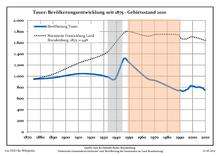
Development of Population since 1875 within the Current Boundaries (Blue Line: Population; Dotted Line: Comparison to Population Development of Brandenburg state; Grey Background: Time of Nazi rule; Red Background: Time of Communist rule)
|
|
|
|
Detailed data sources are to be found in the Wikimedia Commons.[4]
References
- ↑ "Bevölkerung im Land Brandenburg nach amtsfreien Gemeinden, Ämtern und Gemeinden 31. Dezember 2015 (Fortgeschriebene amtliche Einwohnerzahlen auf Grundlage des Zensus 2011)". Amt für Statistik Berlin-Brandenburg (in German). 2016.
- ↑ "Geschichtliches aus der Gemeinde Tauer". Retrieved 27 February 2011.
- ↑ Boundaries as of 2013
- ↑ Population Projection Brandenburg at Wikimedia Commons
External links
![]() Media related to Tauer at Wikimedia Commons
Media related to Tauer at Wikimedia Commons
This article is issued from Wikipedia - version of the 11/7/2016. The text is available under the Creative Commons Attribution/Share Alike but additional terms may apply for the media files.