Tarapoto
| Tarapoto | ||
|---|---|---|
| Town | ||
|
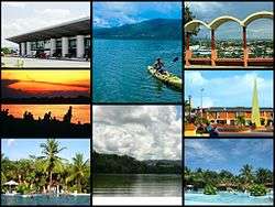
A collage of some places in Tarapoto | ||
| ||
| Nickname(s): City of Palms | ||
 Tarapoto Location of in Peru | ||
| Coordinates: 6°29′S 76°22′W / 6.483°S 76.367°W | ||
| Country |
| |
| Region | San Martín Region | |
| Province | San Martín Province | |
| Demonym | Tarapotino(a) | |
| Founded | 1782 | |
| Elevation | 356 m (1,168 ft) | |
| Population | ||
| • Estimate (2015)[1] | 144,186 | |

Tarapoto, known as the "City of Palms", is a thriving commercial hub in northern Peru, an hour by plane from Lima, situated in the San Martín Province of the San Martín Region, located in the high jungle plateau to the east of what is known as the selva baja (low jungle). Although Moyobamba is the capital of the region, Tarapoto is the region's largest city and is linked to the Upper Amazon and the historic city of Yurimaguas by a relatively well-maintained transandean highway, paved in 2008-9.[2]
Tarapoto sits approximately 356 metres above sea level on the high jungle plateau, also called the cloud forest.[3] It was founded in 1782 by Baltazar Martínez Jiménez de Compagnon. According to the 2007 census Tarapoto has a population of 63,484 within the city limits, and over 117,184 inhabitants including the outlying Morales and Banda de Shilcayo districts.
Tarapoto is often used by tourists and local visitors as a base for excursions into the vast Amazon Rainforest. The region's main activities are tourism, commerce, agriculture and a thriving illicit "shadow economy" that includes production of coca leaves, extraction of lumber and trading in land concessions.
Tarapoto is home to the Universidad Nacional de San Martín, an important center of higher education serving the professional and technical needs of a region of high biodiversity.[4] With its active nightlife, Tarapoto offers a wide variety of hotels and restaurants in and around the city. Moreover, the area's beautiful landscapes, waterfalls and lagoons form a tempting location for adventure tourism, such as river rafting and hiking in the tropical Andes, and attract numerous visitors to the "City of Palms".
History

Tarapoto was founded on August 20, 1782 by the Spanish bishop Baltazar Jaime Martínez de Compagnon y Bujanda. Its beginnings date back to the explorations of the Pocras and Chancas (old cultures of the Ayacucho region) who, when being conquered by the Inca Empire, headed a revolution led by the commander Ancohallo; a revolt that, when defeated, forced their tribal members to escape from terrible Inca vengeance.
Eventually settling down in the valleys of the Mayo and Cumbaza rivers, in what is now San Martín Region, they possibly formed the town of Lamas, before establishing a satellite in the valley of the rivers Cumbaza and Shilcayo, having as a central nucleus the Suchiche Lagoon (dried up in the colony). In this lagoon grew abundant Taraputus palms, a name that the Spanish bishop would later use when founding the city in this area of hunters and fishermen.
Founded September 14, 1906, Tarapoto is the main tourist and commercial hub of this part of northeastern Peru.
The city is located in the valleys of the Cumbaza and Shilcayo rivers, and is the center of the terrestrial networks and areas between the mountains, the coast and eastern Peru.
Climate
| Climate data for Tarapoto (1961–1990) | |||||||||||||
|---|---|---|---|---|---|---|---|---|---|---|---|---|---|
| Month | Jan | Feb | Mar | Apr | May | Jun | Jul | Aug | Sep | Oct | Nov | Dec | Year |
| Average high °C (°F) | 32.9 (91.2) |
32.5 (90.5) |
32.0 (89.6) |
31.8 (89.2) |
31.8 (89.2) |
31.6 (88.9) |
31.6 (88.9) |
32.9 (91.2) |
32.6 (90.7) |
32.7 (90.9) |
32.9 (91.2) |
33.1 (91.6) |
32.4 (90.3) |
| Average low °C (°F) | 20.0 (68) |
19.8 (67.6) |
19.9 (67.8) |
19.8 (67.6) |
19.3 (66.7) |
18.5 (65.3) |
17.9 (64.2) |
18.3 (64.9) |
19.1 (66.4) |
19.4 (66.9) |
19.6 (67.3) |
20.0 (68) |
19.3 (66.7) |
| Average precipitation mm (inches) | 97.7 (3.846) |
119.5 (4.705) |
137.0 (5.394) |
135.3 (5.327) |
100.9 (3.972) |
68.8 (2.709) |
58.8 (2.315) |
64.5 (2.539) |
78.8 (3.102) |
117.8 (4.638) |
96.2 (3.787) |
86.8 (3.417) |
1,162.1 (45.752) |
| Source: NOAA[5] | |||||||||||||
Access and transportation
Tarapoto is one hour by air from Lima and is served by the Cad. FAP Guillermo del Castillo Paredes Airport. This airport is the third-most important in Peru in flow of passengers and cargo. It operates flights to and from Lima on a daily basis, as well as being a stopover to other cities, such as Iquitos and Pucallpa, from Lima.
Lima can be reached by bus in approximately 28 hours. The route runs through Moyobamba and Pedro Ruiz before passing through the coastal city of Chiclayo.
Taxis and motorized rickshaws are frequently used as an inexpensive mode of transportation throughout Tarapoto. Due to the types of the engines used in many taxis, main intersections in Tarapoto are extremely noisy, especially at times of busy traffic. However recently there has been an attempt to certify rickshaws that abide by noise pollution standards.
Accommodation
Tarapoto offers a variety of hotels and guesthouses for tourists and businessmen, both within the city and its surrounding area. A number of resorts also provide for more upmarket tourists.
Local culture
Tarapoto is the site of the headquarters of the National University of San Martín, and the center of the cultural activity of the San Martín region.
Local food
In Tarapoto one can enjoy the most varied food typical of the jungle region. The area is famous for juane, made with rice, egg, olive and chicken, all wrapped up in leaves of bijao. Cured pork products are also common, most notably cecina and chorizo sausage.
Nearby tourist attractions
The spa of Cumbaza, the archaeological remains of the petroglyphs of Polish (Bello Horizonte), abundant plant and animal life, the waterfalls of Ahuashiyacu and Pucayaquillo, the Centro Urku Estudios Amazónicos[6] and the Venice Lagoon are just a few of the area's attractions.
Visitors can enjoy a landscape blessed with a wide variety of flora and fauna, numerous waterfalls and opportunities for adventure tourism (such as white water rafting on the Mayo River, abseiling, jungle expeditions and treks).[7]
Tarapoto is also one of the access points to the remote, but spectacular Rio Abiseo National Park.
Education
For the top level university, Tarapoto has the Universidad Nacional de San Martín with 15 professional careers: Accounting, Agroindustrial Engineering (Juanjui), Agroindustry, Agronomy, Architecture, Civil Engineering, Ecology (Moyobamba), Education-Primary and Secondary (Rioja), Economics, Languages, Management, Medicine, Midwifery, Nursing, Systems Engineering, and Tourism Management.
The National University of San Martín includes an important museum, the Museo Regional-UNSM, which is operated through FUDES (Fundación Para el Desarrollo de la Selva-Universidad Nacional de San Martín). The Regional Museum of the National University of San Martin has a notable anthropology section, which includes both ethnographic and archaeological collections from Peruvian Amazonia.
The Universidad César Vallejo offers careers in Accounting, Law, Psychology, Management, Systems Engineering. Other schools are the Universidad Peruana Union, the Universidad Alas Peruanas, the Instituto Superior Público de Tarapoto, the Instituto Superior Tecnológico Nororiental de la Selva, and numerous private vocational education centers. For special education, Tarapoto has the Education Centre No. 001 for children with Mental Retardation and/or physical limitations and Education Centre No. 002 or Blind Rehabilitation Center (CREC) for the visually impaired.
Use in popular culture
In the fictional Harry Potter Universe, Tarapoto is the hometown of the professional Quidditch team the Tarapoto Tree-Skimmers.[8]
See also
- Comandante FAP Guillermo del Castillo Paredes Airport - Tarapoto's airport
- Lamas, Peru - a town near Tarapoto
- Peruvian Amazon
- San Martín Province
- San Martín Region
- Tarapoto District
- Unión Tarapoto - Tarapoto's football (soccer) team.
References
- ↑ Perú: Población estimada al 30 de junio y tasa de crecimiento de las ciudades capitales, por departamento, 2011 y 2015. Perú: Estimaciones y proyecciones de población total por sexo de las principales ciudades, 2012-2015 (Report). Instituto Nacional de Estadística e Informática. March 2012. Retrieved 4 June 2015.
- ↑ Tarapoto.com
- ↑ http://www.tarapoto.com/servicios/ubicacion.php
- ↑ Info at fudes-unsm.org
- ↑ "Tarapoto Climate Normals 1961–1990". National Oceanic and Atmospheric Administration. Retrieved April 23, 2015.
- ↑ "URKU Estudios Amazónicos – URKU E.A.". www.urkuperu.org. Retrieved 2016-10-14.
- ↑ "5 Best Adventure Activities from Tarapoto". Peru North. Retrieved 2016-10-14.
- ↑ Whisp, Kennilworthy (2001). Quidditch Through the Ages. WhizzHard Books. pp. 31–46. ISBN 1-55192-454-4.
External links
| Wikimedia Commons has media related to Tarapoto. |
Coordinates: 6°29′S 76°22′W / 6.483°S 76.367°W