Talbehat
| Talbehat तालबेहट | |
|---|---|
| Town | |
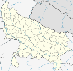 Talbehat Location in Uttar Pradesh, India | |
| Coordinates: 25°02′31″N 78°25′59″E / 25.042°N 78.433°ECoordinates: 25°02′31″N 78°25′59″E / 25.042°N 78.433°E | |
| Country | India |
| State | Uttar Pradesh |
| District | Lalitpur |
| Population (2011) | |
| • Total | 14,176 |
| Languages | |
| • Official | Hindi |
| Time zone | IST (UTC+5:30) |
| Sex ratio | .902 ♂/♀ |
Talbehat is a nagar panchayat city in Lalitpur district in the Indian state of Uttar Pradesh.[1]
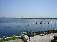
The Fort is situated on Jhansi-Lalitpur four lane road. Raja Mardan Singh ruled here from this fort & he fought along with Rani Laxmi Bai against the Britishers in 1857. The Fort contains three temples, dedicated to Angad, Hanuman & Narsimha . The Fort has massive structures and is situated on the bank of massive Mansarovar Lake. This lake is suitable for various water sports activities.[2] In the premises there is Hazaria Mahadev Temple on the banks of Lake.
Demographics

As of 2011 India census, Talbehat has a population of 14,176 divided into 12 wards. Male population is 7,452 and that of female is 6,724. Talbehat has an average literacy rate of 79.40%, higher than state average of 67.68 %, male literacy is 85.20%, and female literacy is 72.96%. In Talbehat, 12.81% of the population is under 6 years of age. Out of the total population, 4,492 are engaged in work or business activity with 3,678 are males and rest 814 are females.
Schedule Caste (SC) and Schedule Tribe (ST) constitutes 19.06 % and 0.23 % of the total population in Talbehat. Based on the census 88.22% of the total population are Hindus, 7.26% are Muslims, 4.32% are Jains and the rest is occupied by Christian, Sikh and Buddhist.[3]
Transportation
The town is located next to a major highway 26 and main line of Delhi & Bombay train route. Talbehat has very few trains stopping at the railway station established in 1980's, the preferable way to reach is by train from Jhansi or Lalitpur.
Places to visit
The places to visit includes nearby Matatila dam and places of worship such as Pawagir ji Jain temple, Deva Mata Temple and other tourists places includes Talbehat fort, Boat Club and Mansarovar lake.
Talbehat is surrounded by stony ridges descending towards the Betwa river valley. The area receives scanty rainfall.
Temples-N number of temples are in talbehat,Hajaria mahadev ,Madan Mohan Sharkar,Hanuman Gari,Gauri Bhawani are some of them.
Place to Stay- Gahoi Dharamsala ,Sahnai Garden & Bundela guest house.
Marrige Palace-Sahnai Garden ,Sudama Mandapam ,Durga Palace & Bundela Mangal Batika.
References
- ↑ "Talbehat Population Census 2011". Census 2011 - Census of India.
- ↑ Singh, Parvat. "Talbehat Boat Club". Retrieved 28 April 2015.
- ↑ "Talbehat Population Census 2011". Census 2011 - Census of India.