Takhatgarh
| Takhatgarh तखतगढ़ | |
|---|---|
| city | |
 Takhatgarh  Takhatgarh Location in Rajasthan, India | |
| Coordinates: 25°20′N 73°00′E / 25.33°N 73.0°ECoordinates: 25°20′N 73°00′E / 25.33°N 73.0°E | |
| Country |
|
| State | Rajasthan |
| District | Pali |
| Talukas | Sumerpur |
| Government | |
| • Body | Takhatgarh Municipality |
| Area | |
| • Total | 24 km2 (9 sq mi) |
| Elevation | 221 m (725 ft) |
| Population (2011) | |
| • Total | 16,729 |
| • Density | 697/km2 (1,810/sq mi) |
| Languages | |
| • Official | Hindi, Marwari |
| Time zone | IST (UTC+5:30) |
| PIN | 306912 |
| Telephone code | 02933 |
| Vehicle registration | RJ-22 |
| Sex ratio | 948 ♂/♀ |
| Literacy | 58% |
| Lok Sabha constituency | Pali (Lok Sabha Constituency) |
| Vidhan Sabha constituency | Sumerpur |
| Civic agency | Takhatgarh Municipality |
| Avg. annual temperature | 22.5 °C (72.5 °F) |
| Avg. summer temperature | 45 °C (113 °F) |
| Avg. winter temperature | 00 °C (32 °F) |
Takhatgarh is a town in Sumerpur tehsil of Pali District of Rajasthan state in India. The town is one of the 9 municipalities in the district, located near the district border. It is about 150 years old only.
History
The town is named after the "Takhat Singh", then king of Jodhpur. Some people ran away due to atrocities of the Muslims and wanted to settle in the empire of Jodhpur State. They taken permission of the king Takhat Singh and told him their desire that they want to establish a village on king's name and want to settle there. They dug a well, but the water was not sweet. They found one already dug well nearby and taken permission to settle there.

It is said that this well was dug by the 60,000 sons of King Sagar, who dug a well for their father every day. The well is still used as drinking water for the town, which is called Pechka.
After there settlement also the Thakur was coming there, and one soldier of king Pir singh is killed there in struggle with Thakur. Pir Bavasi Majar is situated there now. In 1858 (Vikram Samvat 1914), Takhatgarh's Janma-Patrika prepared by Pandits and Pond, Cremation place, temples etc. established according to the Vastu. So now the town is about 150 years old. Chauhata is also called as Jawahar Chauk, as in 1947 on the occasion of independence here Guard of Honour was given to the country by police. The old Police station was near to Jawahar Chauk only.
Geography
Takhatgarh is located at 25°20′N 73°00′E / 25.33°N 73.0°E.[1] It has an average elevation of 221 metres (725 feet) Area of Takhatgarh is 24 km2.
It is located near the Jalore district border. It lies on Jalore-Sanderao road NH325(old SH-16). Takhatgarh map can be seen on Google Maps.[2] There is one pond and one dam also in Takhatgarh. Pond water is very useful here in increasing water level in wells, used for drinking water supply to the town.
Economy
Here people are mostly agriculture dependents and many people do business in other states like Maharashtra, Karnataka, Tamil Nadu, Gujarat etc. Except SBBJ, here three more banks are Bank of Baroda, MGB Gramin Bank and Pali Co-operative Bank.
In 1961-62, the highest per capita income was recorded at Rs. 17.86 per capita in Takhatgarh Panchayat.[3] The Panchayat was richest in the Rajasthan that time.
Administration

Takhatgarh comes under Sumerpur tehsil of Pali district in Rajasthan state. It is represented in the center under Pali (Lok Sabha constituency), while in state it is represented under the Sumerpur (Rajasthan Assembly constituency).First Sarpanch of the village was Saremal Kesarimal Sanghavi. It is a municipality of class IV since 1974. Takhatgarh was considered as town in 1951, but in the 1961, as definition of the town is changed, so it is made again rural during 1961 to 1974. There are 20 wards for the municipality. Presently Takhatgarh has BJP board and Chairperson is Ms. Ranjana Kumari, who is elected in Municipal election of August 2015.
Takhatgarh municilpality is the only municipality in Rajasthan, which also manage the water supply to the town.
Transport
The usual mode of transport is state owned buses, although private buses are also a part of it, whereas for long journeys trains are preferred and the most preferred station is Falna, which is approx 28 km from the town, while some people prefer Jawai Bandh also.
Demographics
As of 2011 India census,[4] Takhatgarh had a population of 16,729. Males constitute 51% of the population and females 49%. Density per km2 is 678. Growth rate of population from 1991 to 2001 is 28.48% and 2001 to 2011 is 5.8% . Takhatgarh has an average literacy rate of 59%, lower than the national average of 59.5%: male literacy is 71%, and female literacy is 47%. In Takhatgarh, 14% of the population is under 6 years of age.[5]
| Population growth | |||
|---|---|---|---|
| Census | Pop. | %± | |
| 1951 | 5,256 | — | |
| 1981 | 11,106 | — | |
| 1991 | 12,305 | 10.8% | |
| 2001 | 15,809 | 28.5% | |
| 2011 | 16,729 | 5.8% | |
| Source:[World Gazetteer:Pali][6] Data is based on Government of India Census. | |||
People and culture

There ar mainly three religion Hindu, Jain and Muslim. They celebrate every festival with full joy. Deepawali, Holi and Eid are the main festivals here. The town is a center for the nearby all villages.
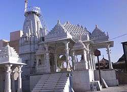
Here people speak mostly Marwari language, while official language is Hindi. There is one Govt Hospital, while many private clinics run by individual doctors. Here life is very peaceful. There is an old (Hindu) temple of Shri Kundeshwar Mahadev and Jain temple of Shri Adinath Bhagwan in the town. There is also temple of Jain deity Ambikadevi situated opposite to hospital. There are many temples of Hindu deities, some of them are Baba Ramdevji temple, Chondra Mataji temple, Mahalaxmi temple, Panchmukhi Hanuman temple, Gogaji Temple. On temple of Takhat Bihari Raj Thakurji's Pran Pratistha is happened on 29 April 2011. This temple is dedicated to the then king Takhat Singhji.
Education
There is one Govt high school, namely Sanghvi Keshari Senior Secondary School, having classes VIII to XII, three Govt. upper primary schools and three Govt Girls Schools out of them one is up to Senior Secondary level. While in Private there are many primary and middle schools out of which Defence Secondary School(An English Medium School), Abhay Nobles School, Tagore Public Senior Secondary school located at jalore road Takhatgarh, is one of the best schools of Takhatgarh, Sainik Children Academy, Saraswati Bal Vidya Mandir and Ray Gandhi Adarsh Vidya Mandir school are main. New Adarsh School is located at Adarsh Nagar in front of the bus stand. On the whole there are totally 22 schools in Takhatgarh. The present municipal administration is also trying to get sanction for a government college in Takhatgarh.One girls college Tagore Girls College,situated at Jalore road takhatgarh affiliated with Jay Narayan Vyas university jodhpur. In takhatgarh one more college namely Shri Rajat College is also there and it is situated near new bus stand. Shri Rajat College, Takhatgarh is working in the field of computer education and distance education. In computer education it is approved from RKCL, Jaipur and providing RS-CIT course. In distance education it is approved centre fron NIMS University, Jaipur, Jaipur National University, Jaipur and Jayoti Vidhyapeeth Women's University, Jaipur providing courses like BA, MA, BSC, MSC, BCOM, BCA, PGDCA, MCA, BBA, MBA, DMLT, BMLT, MMLT, etc.
Sub-areas

Some area in Takhtgarh are: 01) Jodha Nagar (Padarli Road 02) Sainik Colony (Ex Soldiers Coloney) 03) sav.Shri Sher Singh Ji JOdha Margh(gogra road) 04) Khedawas 05) Dhorawas 06) Mahaveer Basti 07) Chakki Gali 08) Ramdev Gali 09) Sutharo ki gali 10) Hanumanji ki Gali 11) Main Bazar 12) Chunda Gali 13) Jogni Gali 14) Nehru chauk (Chauhta) 15) Kachramuta Gali 16) Balana Gali 17) Holi Chauk 18) Masjid area 19) Nehru Road 20) Chauraha 21) Vishwakarma Colony 22) Chandanbala Nagar 23) Taskavawas 24) Adarsh Basti 25) Bandhara Gali 26) Talavo gali 27) Bandi Gali 28) Banshilal Baldia Marg 29) Bheru Chauk 30) Bhilo ki Basti 31) Bokra Gali 32) Gogra Road 33) Kalalo Ki Gali 34) Kharchiyawas 35) Nag Chuak 36) Sado Ki Gali 37) Harijan Basti 38) Ramkavawas 39) Rabariyo ka was 40) Rajpura Road 41) Pechka Gali 42) Suni Gali 43) Sanga Gali
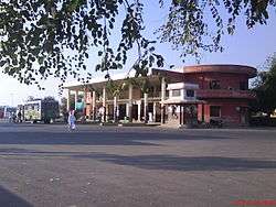
Photo gallery
 Radio design in a building, Takhatgarh, Pali district, Rajasthan
 Talab, Takhatgarh, Pali district, Rajasthan
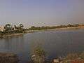 Talab, Takhatgarh, Pali district, Rajasthan
 Shri Ambika Devi, Takhatgarh, Pali district, Rajasthan
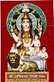 Shri Ambikadevi, Padarli, Jalore district, Rajasthan
References
- ↑ Falling Rain Genomics, Inc - Takhatgarh
- ↑ Takhatgarh Map
- ↑ Sugan Chand Jain (1967). "Community development and panchayati raj in India", p. 180
- ↑ "Census of India 2001: Data from the 2001 Census, including cities, villages and towns (Provisional)". Census Commission of India. Archived from the original on 2004-06-16. Retrieved 2008-11-01.
- ↑ Takhatgath Population
- ↑ "World Gazetteer". Archived from the original on 9 February 2013.
Further reading
External links
- Satellite view of Takhatgarh
- Takhatgarh at Archive.is (archived 2013-02-09)
- Population of Takhatgarh
- Official website of Govt. Senior Secondary School Takhatgarh