Tailem Bend, South Australia
| Tailem Bend South Australia | |
|---|---|
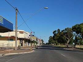 Railway Tce, the main street of Tailem Bend | |
 Tailem Bend | |
| Coordinates | 35°15′0″S 139°27′0″E / 35.25000°S 139.45000°ECoordinates: 35°15′0″S 139°27′0″E / 35.25000°S 139.45000°E |
| Population | 1,457 (2006 census)[1] |
| Established | 1887 |
| Postcode(s) | 5260 |
| Location |
|
| LGA(s) | Coorong District Council |
| State electorate(s) | Hammond |
| Federal Division(s) | Barker |
Tailem Bend is a town on the Murray River in South Australia. The town was proclaimed in 1887, the year after the main railway came through. At the 2006 census, Tailem Bend had a population of 1,457.[1]
Once often written as "Tail'em Bend",[2][3][4] the name is a corruption of the Aboriginal name tailem which was used for the area. The word means bend and is associated with the sharp bend that the Murray River makes in this location.
It is located about 100 km south-east of Adelaide. It is located on the cliffs above the east (left) bank of the Murray River close to where the river empties into Lake Alexandrina. The Tailem Bend Ferry, a cable ferry, operates across the river to Jervois. Major industries in the area include pig farming, dairying, grain growing and Hay Exporting from a Purpose Built Facility.
Tailem Bend is also the head office of the Coorong District Council. The other two minor offices are at Meningie and Tintinara.
Transport
Tailem Bend has junctions on both the railway and highways linking Adelaide to Melbourne.
Railway

There are large grain storage silos and bunkers, where branch lines into the Murray Mallee join the main line. The two remaining branches are the Pinnaroo railway line and the Loxton railway line via Karoonda.[5] The Loxton line was originally one of five branch lines from the Barmera railway line but was the last to remain in service, and the only one to be converted to standard gauge (along with the separate Pinnaroo line) when the main line was converted from broad gauge, however they remain as light rail and ballast with low speed limits. They are only used for collection of bulk grain, as the speed limits are too low to be practical for transport of time-sensitive freight. Both are expected to close in July 2015.[6] The Pinnaroo line continues as the original broad gauge into Victoria to Ouyen where it joins the Mildura to Melbourne line.
Tailem Bend station was once a significant junction station for passenger trains on the Mallee lines, and home to a locomotive depot.
Roads
Tailem Bend is at the end of the South Eastern Freeway from Adelaide. From Tailem Bend, there is a choice of the Dukes Highway as the direct route to Melbourne, the Princes Highway along the Coorong and coast towards Melbourne, or the Mallee Highway east towards Sydney. Tailem Bend is a common stopping point for truck drivers into and out of Adelaide, as there are no further fuel or food outlets with truck facilities on the freeway.
Sport
In March 2016, construction commenced on the The Bend Motorsport Park.[7]
See also
References
- 1 2 Australian Bureau of Statistics (25 October 2007). "Tailem Bend (Urban Centre/Locality)". 2006 Census QuickStats. Retrieved 2010-02-06.
- ↑ "Country Intelligence". The Mount Barker Courier and Onkaparinga and Gumeracha Advertiser (SA : 1880 - 1954). SA: National Library of Australia. 14 March 1884. p. 2. Retrieved 16 August 2015.
- ↑ "From the Metropolis.". The Narracoorte Herald (SA : 1875 - 1954). SA: National Library of Australia. 13 May 1884. p. 3. Retrieved 16 August 2015.
- ↑ ""Augur" in South Australia". The Australasian (Melbourne, Vic. : 1864 - 1946). Melbourne, Vic.: National Library of Australia. 11 May 1889. p. 22. Retrieved 16 August 2015.
- ↑ Mid North & Murray Mallee map SA Track & Signal
- ↑ Freight Study & Rail Operations Investigation Flywheel Advisory 17 November 2014
- ↑ Construction underway at SA Motorsport Park Speedcafe 25 March 2016
External links
| Wikimedia Commons has media related to Tailem Bend, South Australia. |