Tai Long Wan, Sai Kung
- For other places with the same name in Hong Kong, see Tai Long Wan.
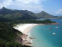

Tai Long Wan (Chinese: 大浪灣; literally: "Big Wave Bay") is a 3 kilometer-wide bay on the east coast of the Sai Kung Peninsula in Hong Kong.[1] Considered one of the most beautiful places in Hong Kong, it is a popular surf destination. In Chinese, Tai Long Wan translates as Big Wave Bay.[2]
Geography
There are four beaches along the bay: Sai Wan (西灣; "West Bay"), also called Tai Long Sai Wan, Ham Tin Wan (鹹田灣), Tai Wan (大灣; "Big Bay") and Tung Wan (東灣; "East Bay"). The three tiny islands of Tsim Chau, Tai Chau and Lan Tau Pai sit picturesquely near the centre of the bay.
Columnar-jointed volcanic rocks characterize the coastline in the south of Tai Long Wan, formed by the cooling and contraction of hot ash during the volcanic eruption in Cretaceous Period. Cliffs in Tai Long Wan are formed in the columnar-joint fine-grained tuffs. These give rise to high, steep cliffs that are commonly penetrated by sea caves and natural sea arches.
History
Artifacts of the Neolithic and Bronze Ages were found in the archaeological site at Ham Tin.[1] Tai Long Tsuen (大浪村), village near Ham Tin Wan, was established over 250 years. ago
Conservation
Tai Long Wan is located within the Sai Kung East Country Park.[3] It was declared a Site of Special Scientific Interest in 1979.[1][4] It also forms an important part of Hong Kong Global Geopark, High Island volcanic rock region.
Section 2 of the Maclehose Trail, one of the most popular hiking trails in Hong Kong, runs through impressive peaks, uplands, peninsulas and bays around Tai Long Wan.
See also
References
| Wikimedia Commons has media related to Tai Long Wan, Sai Kung. |
Coordinates: 22°24′19″N 114°23′22″E / 22.405395°N 114.389464°E