Tadjourah Region
| Tadjourah Region | |
|---|---|
| Region | |
 | |
| Coordinates: 11°47′N 42°54′E / 11.783°N 42.900°ECoordinates: 11°47′N 42°54′E / 11.783°N 42.900°E | |
| Country |
|
| Capital | Tadjourah |
| Area | |
| • Total | 7,100 km2 (2,700 sq mi) |
| Population (2010) | |
| • Total | 84,041 |
| • Density | 12/km2 (31/sq mi) |
| ISO 3166 code | DJ-TA |
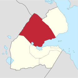
The Tadjourah Region (Somali: Gobolka Tajuura, Afar: Tagórri Rakaakay) is a region in north-central Djibouti, the largest of its six regions. With its capital at Tadjourah, it has an area of 7,100 square kilometres (2,700 sq mi). The region has active salt and fisheries industries, and is served by the Tadjoura Airport.
History
One of the first French people to work in Djibouti the poet Arthur Rimbaud became a trader, and lived in Tadjourah from 1885 to 1886. He was the owner of a particular ship carrying weapons to be sold to the king of Shoa, cousin of the father of future Ethiopian Emperor Haile Selassie. Among the villages in the region include Tadjourah, Kalaf, Sagalou and Hankatta.
Overview
The region is the largest of the country's 'six' (one of which is sometimes termed a city instead of a region, the country's eponymous capital with the bulk of the country's population, Djibouti (city)). A mixture of semi-desert mountains and desert, the region is 35.5 times larger than the capital's area and has a population nine times smaller. The region is bordered by Eritrea to the north, Ethiopia to the northwest, the Obock Region to the northeast, the Dikhil and Arta regions and Lake Asal to the south, and the Gulf of Tadjourah to the southeast.
The capital of the Tadjourah Region is Tadjourah city. Mousa Ali, the highest point in Djibouti is in the northern part. Tadjourah City is one of two ports in the northern part of the country. Administrative and customary center Tadjourah is also an important trading center. The small city also plays an important role in the political stability of Djibouti. The main towns are: Sagallou, Dorra Bankoualé, Randa, Adailou, Garbannab, Guirori, Kalaf, Assa-Gueyla, Balho, Bouyya, Mouddo, The Day and Ambado. Besides its deep religious tradition with its seven mosques it has far-reaching panoramas.
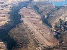
Due to its many whitewashed buildings and structures, Tadjourah is known as the White City. Most people in the wider region are involved in marine commerce, including a large number of fishermen. The region has sandy beaches, tourism and trade. It exports salts from deposits around Lake Assal, one of the country's main natural resources. Tadjourah will soon have a modern port, complementary to that of Djibouti City and the fisheries industry is growing. The western half of it is steep valleys and high escarpments. Almost 65% of its area can be considered agricultural to the extent of seasonal grazing in many years and a minority of land in the wettest areas such as the south-western highlands near Randa near the south support year-round grazing and subsistence crop agriculture for a few months of the year, being mild and semi-arid.
According to the 2009 Census, the local population consists of 89,567 individuals, 48,402 of whom are nomads.
Day Forest

The region has the roughly circular Day Forest National Park in many, often precipitous valleys of the Goda Mountains which is set back from the coastal RN9 route from Tadjourah City to the west. This it the main road of the region, providing a circuitous, up and down route to the capital city compared to the sea route which is approximately a fifth of the distance. It also provides the only proper road of the region into Ethiopia.[1] This is the largest forest in the country, a semi-arid surrounded by semi-desert, with four dominant species: Juniperus procera, Olea africana, Buxus hildebrantii, and Tarchonanthus camphoratus.
Climate
Elevations play a major factor in temperature, with the escarpments and plateaus on average 11°C (20°F) cooler, day or night. The climate of the coastal strip is influenced by warm ocean waters, keeping the closest parts free from extremes highs and providing occasional rainfall. The overnight lows in the highlands - the western half of the region - drop to about 50–54 °F (10–12.2 °C).
The annual mean statistics for some Tadjoura Region centres is shown below:
| Town | Min. Temp | Max. Temp | Rainfall |
|---|---|---|---|
| Tadjoura | 22.2 °C (72.0 °F) | 41.7 °C (107.1 °F) | 145 mm (5.7 in) |
| Adailou | 13.7 °C (56.7 °F) | 34.4 °C (93.9 °F) | 322 mm (12.7 in) |
| Randa | 13.7 °C (56.7 °F) | 34.7 °C (94.5 °F) | 325 mm (12.8 in) |
| Airolaf | 10.9 °C (51.6 °F) | 31.9 °C (89.4 °F) | 431 mm (17.0 in) |
| Dorra | 20.1 °C (68.2 °F) | 39.5 °C (103.1 °F) | 148 mm (5.8 in) |
Transportation
For air transportation, the Tadjourah Region is served by the Tadjoura Airport.
Towns
- Tadjourah
- `Assa Gaila
- Ambabbo
- Randa
- Dorra
- Balho
- Airolaf
- Bankouale
- Madgoul
- Debne
- Adailou
- Sagallo
- Guirrari
- Malaho
- Bouyya
References
- "Djibouti". World Factbook. Central Intelligence Agency. 2007-09-06. Retrieved 2007-09-18.
- ↑ Ham, Anthony; Bainbridge, James (2010-07-30). Lonely Planet Africa. Lonely Planet. pp. 653–. ISBN 9781741049886. Retrieved 3 November 2012.