Swain Reefs National Park
| Swain Reefs National Park Queensland | |
|---|---|
|
IUCN category II (national park) | |
| Coordinates | 21°14′22″S 151°50′48″E / 21.23944°S 151.84667°ECoordinates: 21°14′22″S 151°50′48″E / 21.23944°S 151.84667°E |
| Established | 1995 |
| Area | 0.58 km2 (0.22 sq mi) |
| Managing authorities | Queensland Parks and Wildlife Service |
| See also | Protected areas of Queensland |
Swain Reefs is a national park in North Queensland, Australia, 703 km north of Brisbane. It was established in 1995 and covers an area of 0.58 km2. It is managed by the Queensland Parks and Wildlife Service.
Important Bird Area
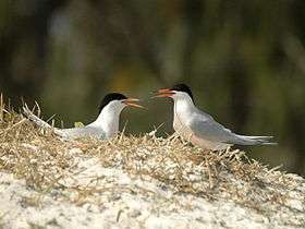
Nine small cays, with a combined area of 9 ha, comprise the Swain Reefs Important Bird Area (IBA), identified as such by BirdLife International because together they support over 1% of the world population of breeding roseate terns, and even larger numbers of non-breeding roseate terns, with up to 25,000 individuals recorded there.[1] Other birds recorded on the cays include masked and brown boobies, silver gulls, black-naped, sooty, bridled, greater crested, lesser crested and little terns, black and common noddies, and lesser frigatebirds. Cays supporting seabirds include Gannet Cay (1.7 ha), Bylund Cay (0.6 ha), Thomas Cay (1 ha), Bacchi Cay (0.5 ha), Frigate Cay (2 ha), Price Cay (1.6 ha), Distant Cay (0.25 ha), Riptide Cay (0.25 ha) and Bell Cay (1.5 ha).[2]
See also
References
- ↑ "IBA: Swain Reefs". Birdata. Birds Australia. Retrieved 2011-10-26.
- ↑ BirdLife International. (2011). Important Bird Areas factsheet: Swain Reefs. Downloaded from http://www.birdlife.org on 2011-10-26.