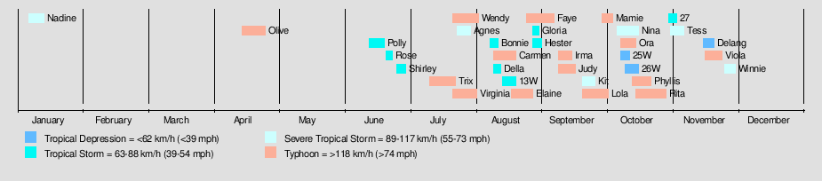
1978 Pacific typhoon season
| |
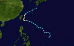
| Season summary map |
| First system formed |
January 6, 1978 |
| Last system dissipated |
December 16, 1978 |
| Strongest storm1 |
Rita – 878 hPa (mbar), 220 km/h (140 mph) (10-minute sustained) |
| Total depressions |
34 |
| Total storms |
30 |
| Typhoons |
15 |
| Super typhoons |
1 |
| Total fatalities |
Unknown |
| Total damage |
Unknown |
| 1Strongest storm is determined by lowest pressure |
Pacific typhoon seasons
1976, 1977, 1978, 1979, 1980 |
The 1978 Pacific typhoon season has no official bounds; it ran year-round in 1978, but most tropical cyclones tend to form in the northwestern Pacific Ocean between June and December. These dates conventionally delimit the period of each year when most tropical cyclones form in the northwestern Pacific Ocean.
The scope of this article is limited to the Pacific Ocean, north of the equator and west of the international date line. Storms that form east of the date line and north of the equator are called hurricanes; see 1978 Pacific hurricane season. Tropical Storms formed in the entire west pacific basin were assigned a name by the Joint Typhoon Warning Center. Tropical depressions in this basin have the "W" suffix added to their number. Tropical depressions that enter or form in the Philippine area of responsibility are assigned a name by the Philippine Atmospheric, Geophysical and Astronomical Services Administration or PAGASA. This can often result in the same storm having two names.
Storms
33 tropical depressions formed this year in the Western Pacific, of which 29 became tropical storms. 15 storms reached typhoon intensity, of which 1 reached super typhoon strength. Many of the storms either remained at sea or failed to do any damage.
Severe Tropical Storm Nadine
| Severe tropical storm (JMA) |
| Tropical storm (SSHWS) |
|
|
| Duration |
January 6 – January 13 |
| Peak intensity |
100 km/h (65 mph) (10-min) 970 hPa (mbar) |
Typhoon Olive (Atang)
| Typhoon (JMA) |
| Category 2 typhoon (SSHWS) |
|
|
| Duration |
April 15 – April 26 |
| Peak intensity |
150 km/h (90 mph) (10-min) 955 hPa (mbar) |
In the Philippines, Typhoon Olive (Atang) killed 3 people and left 3,500 homeless.[1] A lengthened ex-”FS” ship of Compania Maritima was caught in it, the MV Leyte. She was wrecked in the southwestern portion of Sibuyan Island trying to reach shelter. She was then on a Manila-Cebu voyage.[2]
Tropical Storm Polly (Bising)
| Tropical storm (JMA) |
| Tropical storm (SSHWS) |
|
|
| Duration |
June 13 – June 20 |
| Peak intensity |
85 km/h (50 mph) (10-min) 985 hPa (mbar) |
Tropical Storm Rose (Klaring)
| Tropical storm (JMA) |
| Tropical storm (SSHWS) |
|
|
| Duration |
June 21 – June 24 |
| Peak intensity |
85 km/h (50 mph) (10-min) 990 hPa (mbar) |
Tropical Storm Shirley (Deling)
| Tropical storm (JMA) |
| Tropical storm (SSHWS) |
|
|
| Duration |
June 26 – June 30 |
| Peak intensity |
85 km/h (50 mph) (10-min) 992 hPa (mbar) |
Typhoon Trix
| Typhoon (JMA) |
| Category 1 typhoon (SSHWS) |
|
|
| Duration |
July 11 – July 23 |
| Peak intensity |
130 km/h (80 mph) (10-min) 965 hPa (mbar) |
Typhoon Virginia
| Typhoon (JMA) |
| Category 1 typhoon (SSHWS) |
|
|
| Duration |
July 22 – August 2 |
| Peak intensity |
130 km/h (80 mph) (10-min) 975 hPa (mbar) |
Typhoon Wendy (Emang)
| Typhoon (JMA) |
| Category 1 typhoon (SSHWS) |
|
|
| Duration |
July 22 – August 3 |
| Peak intensity |
130 km/h (80 mph) (10-min) 960 hPa (mbar) |
Severe Tropical Storm Agnes
| Severe tropical storm (JMA) |
| Tropical storm (SSHWS) |
|
|
| Duration |
July 24 – July 30 |
| Peak intensity |
100 km/h (65 mph) (10-min) 980 hPa (mbar) |
Agnes formed on July 24, made a complete loop, and struck China on July 29 with winds of 55 mph after peaking at 60 mph.[3] It dissipated the 30th. In Hong Kong Tropical Storm Agnes killed 3 people.[4]
Tropical Storm Bonnie (Gading)
| Tropical storm (JMA) |
| Tropical storm (SSHWS) |
|
|
| Duration |
August 8 – August 12 |
| Peak intensity |
75 km/h (45 mph) (10-min) 985 hPa (mbar) |
Typhoon Carmen (Iliang)
| Typhoon (JMA) |
| Category 4 typhoon (SSHWS) |
|
|
| Duration |
August 10 – August 20 |
| Peak intensity |
215 km/h (130 mph) (10-min) 935 hPa (mbar) |
Tropical Storm Della (Heling)
| Tropical storm (JMA) |
| Tropical storm (SSHWS) |
|
|
| Duration |
August 10 – August 13 |
| Peak intensity |
85 km/h (50 mph) (10-min) 985 hPa (mbar) |
Tropical Storm 13W
| Tropical storm (JMA) |
| Tropical depression (SSHWS) |
|
|
| Duration |
August 14 – August 20 |
| Peak intensity |
75 km/h (45 mph) (10-min) 999 hPa (mbar) |
Typhoon Elaine (Miding)
| Typhoon (JMA) |
| Category 1 typhoon (SSHWS) |
|
|
| Duration |
August 18 – August 28 |
| Peak intensity |
120 km/h (75 mph) (10-min) 965 hPa (mbar) |
Typhoon Faye
| Typhoon (JMA) |
| Category 3 typhoon (SSHWS) |
|
|
| Duration |
August 25 – September 7 |
| Peak intensity |
165 km/h (105 mph) (10-min) 935 hPa (mbar) |
Tropical Storm Gloria (Oyang)
| Tropical storm (JMA) |
| Tropical storm (SSHWS) |
|
|
| Duration |
August 28 – August 31 |
| Peak intensity |
75 km/h (45 mph) (10-min) 992 hPa (mbar) |
Tropical Storm Hester
| Tropical storm (JMA) |
| Tropical storm (SSHWS) |
|
|
| Duration |
August 28 – September 1 |
| Peak intensity |
85 km/h (50 mph) (10-min) 990 hPa (mbar) |
Typhoon Irma (Ruping)
| Typhoon (JMA) |
| Category 1 typhoon (SSHWS) |
|
|
| Duration |
September 9 – September 15 |
| Peak intensity |
120 km/h (75 mph) (10-min) 970 hPa (mbar) |
Irma, the eighth typhoon of the 1978 season, developed in the monsoon trough southeast of Taiwan.[5] It made landfall in Honshu, Japan. With winds of up to 120 km/h, Typhoon Irma killed at least 6 people and made about 3,000 homeless. Four people were missing and about 100 were injured by floods and landslides in southwestern Japan.[6] It destroyed or damaged 1,597 homes and left 6,266 homes flooded.[7] Irma smashed windows, overturned cars, and capsized several fishing boats. Several athletes at the Japan-China Friendship Track and Field Meet in Kitakyushu were injured when a freak gust blew them ten feet in the air. A Liberian-registered tanker was swept from its moorings off the port of Kure and drifted for nearly 5 kilometers before running aground off a small island in the Inland Sea.[6] Irma remained a typhoon for only 12 hours becoming the shortest-lived typhoon of the season.[5]
Typhoon Judy
| Typhoon (JMA) |
| Category 2 typhoon (SSHWS) |
|
|
| Duration |
September 9 – September 17 |
| Peak intensity |
150 km/h (90 mph) (10-min) 950 hPa (mbar) |
Severe Tropical Storm Kit
| Severe tropical storm (JMA) |
| Tropical storm (SSHWS) |
|
|
| Duration |
September 20 – September 26 |
| Peak intensity |
95 km/h (60 mph) (10-min) 990 hPa (mbar) |
Typhoon Lola (Weling)
| Typhoon (JMA) |
| Category 1 typhoon (SSHWS) |
|
|
| Duration |
September 20 – October 2 |
| Peak intensity |
130 km/h (80 mph) (10-min) 965 hPa (mbar) |
Typhoon Mamie
| Typhoon (JMA) |
| Category 1 typhoon (SSHWS) |
|
|
| Duration |
September 29 – October 4 |
| Peak intensity |
130 km/h (80 mph) (10-min) 960 hPa (mbar) |
Severe Tropical Storm Nina (Aning)
| Severe tropical storm (JMA) |
| Tropical storm (SSHWS) |
|
|
| Duration |
October 6 – October 16 |
| Peak intensity |
110 km/h (70 mph) (10-min) 975 hPa (mbar) |
According to the official reports, 59 people died and more than 500,000 were in evacuation centers in the Philippines.[8]
Typhoon Ora (Yaning)
| Typhoon (JMA) |
| Category 2 typhoon (SSHWS) |
|
|
| Duration |
October 8 – October 15 |
| Peak intensity |
150 km/h (90 mph) (10-min) 940 hPa (mbar) |
Tropical Depression 25W
| Tropical depression (PAGASA) |
| Tropical depression (SSHWS) |
|
|
| Duration |
October 8 – October 12 |
| Peak intensity |
55 km/h (35 mph) (10-min) 999 hPa (mbar) |
Tropical Depression 26W
| Tropical depression (SSHWS) |
|
|
| Duration |
October 10 – October 16 |
| Peak intensity |
35 km/h (25 mph) (1-min) 1002 hPa (mbar) |
Typhoon Phyllis
| Typhoon (JMA) |
| Category 2 typhoon (SSHWS) |
|
|
| Duration |
October 13 – October 22 |
| Peak intensity |
150 km/h (90 mph) (10-min) 955 hPa (mbar) |
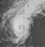
Super Typhoon Rita (Kading)
| Typhoon (JMA) |
| Category 5 super typhoon (SSHWS) |
|
|
| Duration |
October 15 – October 29 |
| Peak intensity |
220 km/h (140 mph) (10-min) 878 hPa (mbar) |
Tropical Depression 28 developed October 15. Three and a half days later, it strengthened into a tropical storm. Rita became a typhoon late on October 19. Rita reached Category 5 status on October 23, reaching a minimum central pressure of 878 millibars, only 8 mb higher than Typhoon Tip's record set in 1979. After spending over three consecutive days at that intensity, Rita weakened to a Category 4 and smashed ashore on Luzon. Rita stayed a typhoon during its entire passage over the Philippines and emerged into the South China Sea as a minimal typhoon. Rita then decayed slowly and dissipated as a depression near the coast of Vietnam. The typhoon caused considerable damage and loss of life in the Philippines, though exact numbers are unknown.
Tropical Storm 27
| Tropical storm (JMA) |
|
|
| Duration |
October 30 – November 3 |
| Peak intensity |
65 km/h (40 mph) (10-min) 994 hPa (mbar) |
Severe Tropical Storm Tess
| Severe tropical storm (JMA) |
| Tropical storm (SSHWS) |
|
|
| Duration |
October 31 – November 6 |
| Peak intensity |
110 km/h (70 mph) (10-min) 975 hPa (mbar) |
A tropical depression developed on October 31. The depression was upgraded to a tropical storm on November 2. Tess continued to intensify and reached it's peak intensity as a 70 mph (110 km/h) storm; just short of typhoon status. The storm became extratropical on November 7.
Tropical Depression 30W (Delang)
| Tropical depression (PAGASA) |
| Tropical depression (SSHWS) |
|
|
| Duration |
November 15 – November 20 |
| Peak intensity |
55 km/h (35 mph) (10-min) 1002 hPa (mbar) |
Typhoon Viola (Esang)
| Typhoon (JMA) |
| Category 4 typhoon (SSHWS) |
|
|
| Duration |
November 16 – November 24 |
| Peak intensity |
195 km/h (120 mph) (10-min) 910 hPa (mbar) |
Increased convective activity in the monsoon trough was first noticed on satellite data on November 14 about 690 mi (1110 km) southeast of Truk. On November 16, the disturbance was upgraded to Tropical Depression 33. Based on an improved satellite signature, TD 33 was upgraded to Tropical Storm Viola at 1200 UTC November 17.[3] Viola continued to intensify as the storm moved on a northwestward track.[9] Late on November 19 reconnaissance aircraft confirmed that viola’s surface pressure had fallen to 977 mb; and, that an eye was beginning to form. Early on November 20, Viola was upgraded to a typhoon. Viola then started to rapidly intensify and reached peak intensity on November 21 with winds of 145 mph (230 km/h). Viola recurved away form Luzon on November 22.[3] By the next day, the storm had already weakened to a category 1 and further weakened to a tropical storm. Viola dissipated on November 24.[9]
Severe Tropical Storm Winnie
| Severe tropical storm (JMA) |
| Tropical storm (SSHWS) |
|
|
| Duration |
November 25 – November 30 |
| Peak intensity |
100 km/h (65 mph) (10-min) 980 hPa (mbar) |
A tropical depression developed on November 25. It started to intensify while moving on a north-northwestward track. By November 28,the depression was upgraded to a tropical storm and was named Winnie. On the 29th, Winnie reached it's peak intensity as severe tropical storm with (10-min) winds of 65 mph (100 km/h). Winnie became extratropical early on November 30.
Tropical Depression Garding
| Tropical depression (PAGASA) |
|
|
| Duration |
December 13 – December 16 |
| Peak intensity |
55 km/h (35 mph) (10-min) |
Storm names
During the season 28 named tropical cyclones developed in the Western Pacific and were named by the Joint Typhoon Warning Center, when it was determined that they had become tropical storms. These names were contributed to a revised list from late-1950. However the JTWC changed their naming scheme by the next year, now including both female and male names.
| Nadine | Olive | Polly | Rose | Shirley | Trix | Virginia | Wendy | Agnes | Bonnie | Carmen | Della | Elaine | Faye |
| Gloria | Hester | Irma | Judy | Kit | Lola | Mamie | Nina | Ora | Phyllis | Rita | Tess | Viola | Winnie |
One name, Susan, developed over the Central Pacific and was named from this list. The storm never became apart of the West Pacifc basin.
Philippines
| Akang | Bising | Klaring | Deling | Emang |
| Gading | Heling | Iliang | Loleng | Miding |
| Norming | Oyang | Pasing | Ruping | Susang |
| Tering | Uding | Weling | Yaning | |
| Auxiliary list |
| | | | | Aning |
| Bidang | Kading | Delang | Esang | Garding |
The Philippine Atmospheric, Geophysical and Astronomical Services Administration uses its own naming scheme for tropical cyclones in their area of responsibility. PAGASA assigns names to tropical depressions that form within their area of responsibility and any tropical cyclone that might move into their area of responsibility. Should the list of names for a given year prove to be insufficient, names are taken from an auxiliary list, the first 6 of which are published each year before the season starts. Names not retired from this list will be used again in the 1982 season. This is the same list used for the 1974 season. PAGASA uses its own naming scheme that starts in the Filipino alphabet, with names of Filipino female names ending with "ng" (A, B, K, D, etc.). Names that were not assigned/going to use are marked in gray.
Retirement
Due to extreme damages and death toll caused by Typhoon Rita (Kading), PAGASA retired the name Kading in its auxiliary list. The name replaced was Katring.
See also
References
- ↑ "Typhoon". The Canberra Times. April 27, 1978. Retrieved October 23, 2016 – via Trove.
- ↑ "Typhoon "Atang" | Philippine Ship Spotters Society". psssonline.wordpress.com. Retrieved 2016-10-23.
- 1 2 3 1978 ATCR TABLE OF CONTENTS
- ↑ Historical Information
- 1 2 Morford, Dean R.; Lavin, James K. (January 1, 1995). "1978 Annual Typhoon Report" (PDF). Retrieved October 23, 2016.
- 1 2 "Typhoon Irma leaves 3,000 homeless". The Canberra Times. September 18, 1978. Retrieved September 22, 2016 – via Trove.
- ↑ "Typhoon brushes Japan; 6 die (September 16, 1978)". Retrieved 2016-10-23.
- ↑ "59 flood deaths". The Canberra Times. October 13, 1978. Retrieved October 23, 2016 – via Trove.
- 1 2 . Unisys Weather http://weather.unisys.com/hurricane/w_pacific/1978/31/track.dat. Retrieved 2016-11-25.
External links