Sundarbans National Park
| Sundarbans National Park | |
|---|---|
| সুন্দরবন জাতীয় উদ্যান | |
|
IUCN category II (national park) | |
|
Tiger from Sundarbans Tiger Reserve | |
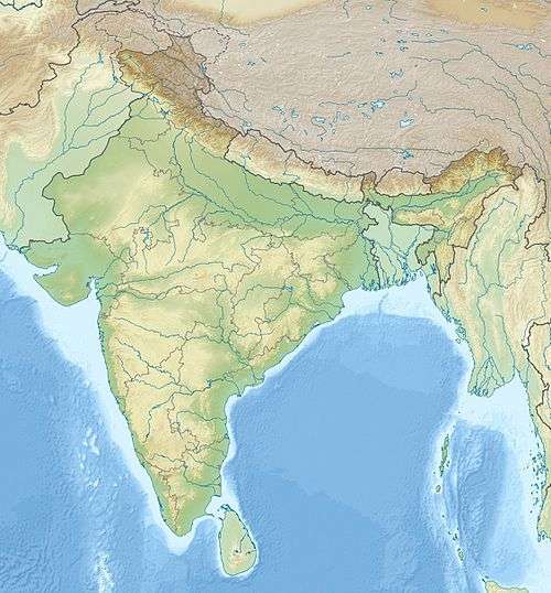 Location in West Bengal, India | |
| Location | South 24 Parganas, West Bengal, India |
| Nearest city | Kolkata |
| Coordinates | 21°56′42″N 88°53′45″E / 21.94500°N 88.89583°ECoordinates: 21°56′42″N 88°53′45″E / 21.94500°N 88.89583°E |
| Area | 1,330.12 km2 (328,680 acres) |
| Established | 1984 |
| Governing body | Government of India |
| Type | Natural |
| Criteria | ix, x |
| Designated | 1987 (11th session) |
| Reference no. | 452 |
| State Party | India |
| Region | Asia-Pacific |

The Sundarban National Park (Bengali: সুন্দরবন জাতীয় উদ্যান Shundorbôn Jatiyo Udyan) is a National Park, Tiger Reserve, and a Biosphere Reserve in West Bengal, India. It is part of the Sundarbans on the Ganges Delta, and adjacent to the Sundarban Reserve Forest in Bangladesh. The delta is densely covered by mangrove forests, and is one of the largest reserves for the Bengal tiger. It is also home to a variety of bird, reptile and invertebrate species, including the salt-water crocodile. The present Sundarban National Park was declared as the core area of Sundarban Tiger Reserve in 1973 and a wildlife sanctuary in 1977. On 4 May 1984 it was declared a National Park.
Administration

The Directorate of Forest is responsible for the administration and management of Sundarban. The Principal Chief Conservator of Forests (PCCF), Wildlife & Bio-Diversity & ex-officio Chief Wildlife Warden, West Bengal is the senior most executive officer looking over the administration of the park. The Chief Conservator of Forests (South) & Director, Sundarban Biosphere Reserve is the administrative head of the park at the local level and is assisted by a Deputy Field Director and an Assistant Field Director. The park area is divided into two ranges, overseen by range forest officers. Each range is further sub-divided into beats. The park also has floating watch stations and camps to protect the property from poachers.
The park receives financial aid from the State Government as well as the Ministry of Environment and Forests under various Plan and Non-Plan Budgets. Additional funding is received under the Project Tiger from the Central Government. In 2001, a grant of US$20,000 was received as a preparatory assistance for promotion between India and Bangladesh from the World Heritage Fund.
Geography
Sundarban National Park is located in between 21° 432' – 21° 55' N latitude and between 88° 42' – 89° 04' E longitude. The average altitude of the park is 7.5 m above sea level. The park is made up of 54 small islands and is crisscrossed by several distributaries of the Ganges.
Climate Temperature
The average minimum and maximum temperature is 20 °C and 48 °C respectively. Rainfall is heavy with humidity as high as 80% as it is close to the Bay of Bengal. The monsoon lasts from mid-June to mid-September. Prevailing wind is from the north and north-east from October to mid-March and south west westerlies prevails from mid-March to September. Storms which sometimes develop into cyclones are common during the months of May and October.
Eco-geography, rivers and watercourses
There are seven main rivers and innumerable watercourses forming a network of channels at this estuarine delta. All the rivers have a southward course towards the sea. The eco-geography of this area is totally dependent on the tidal effect of two flow tides and two ebb tides occurring within 24 hours with a tidal range of 3–5 m and up to 8 m[1][2] in normal spring tide, inundating the whole of Sunderban in varying depths. The tidal action deposits silts back on the channels and raising the bed, it forms new islands and creeks contributing to uncertain geomorphology.[3] There is a great natural depression called "Swatch of No Ground" in the Bay of Bengal between 21°00' to 21°22' latitude where, the depth of water changes suddenly from 20 m to 500 m.[1][4] This mysterious depression pushes back the silts towards south and/or further east to form new islands.
Mudflats
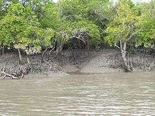
The Sunderban mudflats[2] are found at the estuary and on the deltaic islands where low velocity of river and tidal current occurs. The flats are exposed in low tides and submerged in high tides, thus being changed morphologically even in one tidal cycle. The interior parts of the mudflats are the right environment for mangroves.
There are a number of mudflats outside the Sundarbans National Park is a mudflat that have the potential to be tourist spots in the Sundarbans. One can visit them and enjoy the beauty of the place during low tide. If one is lucky, one can see Sea Anemones, Horseshoe crab (Nearing extinction)and small octopus.
Flora and fauna
The coastal active delta of Sunderban at the mouth of Bay of Bengal in Bangladesh, having a complex geomorphologic and hydrological character with climatic hazards, has a vast area of mangrove forests with a variety of flora and diverse fauna in a unique ecosystem. The natural environment and coastal ecosystem of this Biosphere Reserve and World Heritage Site is under threat of physical disaster due to unscientific and excessive human interferences. Conservation and environmental management plan for safeguarding this unique coastal ecology and ecosystem is urgently required.
Flora
Sundarban has achieved its name from the Sundari Trees. It is the most exquisite variety of tree that are found in this area, a special kind of Mangrove tree. It has specialised roots called pneumatophore which emerge above ground and help in gaseous exchange i.e. respiration. During the rainy season when the entire forest is waterlogged, the spikes rising from the ground has their peak in the air and helps in the respiration process.
Fauna
The Sundarbans forest is home to more than 400 tigers. The royal Bengal tigers have developed a unique characteristic of swimming in the saline waters, and are famous for their man-eating tendencies. Tigers can be seen on the river banks sunbathing between November and February. Apart from the Bengal tiger, Fishing cats, Leopard cats, Macaques, Wild boar, Indian grey mongoose, Fox, Jungle cat, Flying fox, Pangolin, Chital, are also found in abundance in the Sundarbans.
Avifauna
Some of the birds commonly found in this region are openbill storks, black-capped kingfishers, black-headed ibis, water hens, coots, pheasant-tailed jacanas, pariah kites, brahminy kite, marsh harriers, swamp partridges, red junglefowl, spotted doves, common mynahs, jungle crows, jungle babblers, cotton teals, herring gulls, Caspian terns, gray herons, common snipes, wood sandpipers, green pigeons, rose ringed parakeets, paradise-flycatchers, cormorants, grey-headed fish eagles, white-bellied sea eagles, seagulls, common kingfishers, peregrine falcons, woodpeckers, whimbrels, black-tailed godwits, little stints, eastern knots, curlews, golden plovers, northern pintails, white-eyed pochards and whistling teals.
Aquatic fauna
Some of the aquatic animals found in the park are sawfish, butter fish, electric rays, silver carp, starfish, common carp, horseshoe crabs, prawn, shrimps, Gangetic dolphins, skipping frogs, common toads and tree frogs.
Reptiles
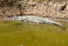
The Sundarbans National Park houses a large number of reptiles as well, including estuarine crocodiles, chameleons, monitor lizards, turtles, including olive ridley, hawksbill, and green turtles; and snakes including python, king cobra, rat snake, Russell's viper, dog faced water snake, checkered keelback, and common krait.
Endangered species
The endangered species that lives within the Sundarbans are royal Bengal tiger, saltwater crocodile, river terrapin, olive ridley turtle, Ganges River dolphin, hawksbill turtle and mangrove horseshoe crab.
Marine mammals
The proposed Sundarbans Cetacean Diversity Protected Area,[5] includes the coastal waters off Sundarbans that host critical habitats for endangered cetaceans;[6] resident groups of Bryde's whales, a newly rediscovered critical population of Irrawaddy dolphins,[7] Ganges River dolphins,[8] and humpback dolphins. Finless porpoises, Indo-Pacific bottlenose dolphins, spinner dolphins, and pantropical spotted dolphins are also found in this area.[9]
Management and special projects

Bengal tiger is the commonly found species in this national park. The park had protection since its creation. The core area is free from all human disturbances like collection of wood, honey, fishing and other forest products. However, in the buffer area fishing, honey collection and wood cutting are permitted in limited form. Protection of the park from poaching and theft of forest products is done by well armed forest staff who patrol in motorboats and launches. Forest offices and camps are located at several important parts of the park. Anti-poaching camps are managed by two to three knowledgeable labourers under supervision of concerned beat guard/Forester/Range officer.
Habitat of wildlife is maintained through eco-conservation, eco-development, training, education and research. Ten Forest Protection Committees and 14 Eco-development Committees have been formed in the fringe of Sundarbans Tiger Reserve to help in this regard. Seminars, workshops and awareness camps are organised in the vicinity of park to educate the people on eco-conservation, eco-development and such other issues. Mangrove and other plants are planted in the fringe area to meet the local need of fuel wood for about 1000 villages and to conserve the buffer area. Conservation of soil is done to maintain the ecological balance. Several sweet water ponds have been dug up inside the park to provide drinking water for the wild animals.
Controlling man-eating tigers is another major activity. The number of casualties has been reduced from 40 to 10 per year. The reduction in number of casualties is a result of strict control over the movement of the people inside the tiger reserve, alternative income generation and awareness building among people. It is also believed that due to use of human masks and electric human dummies the tigers will stay away from the people. Straying of tigers into nearby villages is prevented through measures such as nylon net fencing and solar illumination of villages. The youths of the villages are given training in controlling the straying of tigers into the villages.
The Mangrove Interpretation Centre is established at Sajnekhali to make the local people and tourists aware of the importance of conservation of nature in general and specially the mangrove ecosystems.
Constraints
Though protection exists in the park, there are a few loopholes. The geographical topography with hostile terrain cris-crossed by several rivers and their tributaries, long international border with Bangladesh, fishing trawlers and launches enables poaching and the cutting of wood, affecting the mangrove forests. Lack of staff, infrastructure and lack of funds exacerbate the situation.
Park-specific information

The only means of travelling the park is to by boat, down the various lanes formed by the many flowing rivers. Local boats or vessels operated by the West Bengal Tourism Development Corporation, namely M.V. Chitrarekha and M.V. Sarbajaya.

Apart from viewing the wildlife from boat safaris, visitors also visit the Bhagatpur Crocodile Project, a crocodile breeding farm, Sagar Island, Jambudweep, Sudhanyakali watchtower, Buriidabri Tiger Project, Netidhopani Watchtower, Haliday Island, Kanak, and Sajnekhali Bird Sanctuary.
Sunderban Tiger Reserve
Background
The Sunderban Tiger Reserve is located in South 24 Paraganas, West Bengal and has a total geographical area of 2585 km2 with 1437.4 km2 consisting of populated areas and forest covering 1474 km2. Sunderban landscape is continuous with the mangrove habitat in Bangladesh.
Sunderban mangroves form part of the subcontinent's largest mangrove system with a tiger population in a distinct ecological setting. These forests have salt water crocodiles, estuarine and marine turtles and a number of bird species. Besides tiger, the reserve has fishing cat, spotted deer, rhesus monkey and wild pigs.
The Sunderban is isolated with no forest connection to other tiger-occupied main land. Hence, there is heavy biotic pressure for forest resources. On average 500 quintals of honey and 30 quintals of wax are collected each year by local people under licence from Forest Department. The habitat is traversed by many narrow tidal channels forming small to large islands. Tigers readily cross these islands and man-tiger interactions are common.
The estimation of tiger population in Sunderban, as a part of the all India tiger estimation using the refined methodology, could not be carried out owing to the unique habitat and obliteration of evidences due to high and low tides. Phase-I data collection has been completed and process is on for tiger estimation using a combination of radio telemetry and pugmark deposition rate from known tigers.
Damage from Cyclone Aila

Cyclone Aila struck Sunderban on 25 May 2009, causing damage to field camps and fringe villages bordering the reserve. Breaches in the embankments on the village side have caused large scale flooding, leaving lakhs of people marooned in the area. The field camps were under 12 to 15 feet of water for around seven hours, resulting in soil erosion and damage to staff quarters, generators and bamboo pilling. There was a report of a tiger wandering inside an abandoned cattle shed in a village, which was captured and released back in the wild. No tiger death has been reported, apart from mortality of two spotted deer. Several NGOs have been involved in the relief operation.
The Forest Department of the State has constituted a Committee and has assessed a damage of almost Rs. 11150,000. Central assistance amounting to Rs. 10 million under Project Tiger has been provided to the State for restoring the damage done to infrastructure.
Challenges
The Sunderban Tiger Reserve has several challenges to its future operations. Due to wandering tigers, man-tiger conflict continues to be an issue. Sunderban tigers hunt humans, and it is estimated that over a thousand of the local people have been killed by tigers over the past four decades.[10] An estimation of the number of tigers present in the reserve using the refined method has not yet been completed. A tiger conservation plan is awaited as are constitutions for the State level Steering Committee under the Chairmanship of the Chief Minister and the reserve-specific Tiger Conservation Foundation.
Transport
Air: Sundarban National Park is located 140 km far from Kolkata Airport(Also known as Netaji Subash Chandra Bose Airport and Dum Dum Airport)
Rail: The nearest Railway station of Sundarban National Park is Canning Railway station which is located 29 km far from the Gate way of Sundarban (i.e. Godhkhali)
Road:Sundarban National Park is well connected with kolkata – Basanti High way.
Ecosystem Valuation
An economic assessment study of Sundarbans estimated that the tiger reserve provides flow benefits worth 12.8 billion rupees (0.50 lakh / hectare) annually. Important ecosystem services include nursery function (5.17 billion), gene-pool protection (2.87 billion year), provisioning of fish (1.6 billion) and waste assimilation services (1.5 billion). The study also mentioned about services such as generation of employment for local communities (36 million), moderation of cyclonic storms (275 million year), provision of habitat and refugia for wildlife (360 million) and sequestration of carbon (462 million).[11]
See also
- Haliday Island Wildlife Sanctuary
- Indian Council of Forestry Research and Education
- Wildlife sanctuaries in India
- Sangu Matamuhari
References
- 1 2 Ghosh R. K. and Mandal A. K. (1989). Sunderban – a socio bio-ecological study. 1st edition, Bookland Pvt. Ltd. Calcutta.
- 1 2 Banerjee A. (1998). Environment, population and human settlements of Sunderban Delta. 1st edition, Concept Publishing Company, New Delhi.
- ↑ Bhattacharya A.K. (1989). "Coastal geomorphology, processes and hazards : a note on management measures". Proc. Coast zone management of West Bengal, Sea Explorers’ Institute, Calcutta. pp. D49-61.
- ↑ Fergusson J. (1963). "Delta of the Ganges". Quarterly Journal of the Geological Society of India. Vol. XIII. Part-1.
- ↑ Sundarbans, Bay Of Bengal. whales.org
- ↑ Whale and Dolphins Of Sundarban. youtube.com
- ↑ Lawson, Alastair (10 April 2009) Bangladesh dolphins 'back from dead'. BBC
- ↑ Ethirajan, Anbarasan (31 October 2011) Bangladesh dolphins get Sundarbans sanctuaries. BBC
- ↑ Hoyt, Erich (2012). Marine Protected Areas for Whales, Dolphins and Porpoises: A World Handbook for Cetacean Habitat Conservation and Planning. Routledge. pp. 278–. ISBN 978-1-136-53830-8.
- ↑ https://www.youtube.com/watch?v=zHfSTt1tcj0
- ↑ (PDF) http://www.iifm.ac.in/sites/default/files/Newspdf/IIFM-NTCA-REPORT.compressed-min.pdf. Retrieved 14 August 2016. Missing or empty
|title=(help)
External links
- Official UNESCO website entry
-
 Sundarbans National Park travel guide from Wikivoyage
 - UNESCO Periodic Report

| ||