Stonava
| Stonava Stonawa | |||
|---|---|---|---|
| Village | |||
|
Saint Mary Magdalene Church | |||
| |||
 Location in the Czech Republic | |||
| Coordinates: 49°48′44″N 18°31′50″E / 49.81222°N 18.53056°E | |||
| Country | Czech Republic | ||
| Region | Moravian-Silesian | ||
| District | Karviná | ||
| First mentioned | 1388 | ||
| Government | |||
| • Mayor | Andrzej Feber | ||
| Area | |||
| • Total | 13.87 km2 (5.36 sq mi) | ||
| Elevation | 193 m (633 ft) | ||
| Population (2012) | |||
| • Total | 1,828 | ||
| • Density | 130/km2 (340/sq mi) | ||
| Postal code | 735 34 | ||
| Website | http://www.stonava.cz/ | ||

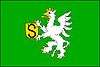
Stonava (Polish: ![]() Stonawa , German: Steinau) is a village in Karviná District, Moravian-Silesian Region, Czech Republic, on the Stonávka River. It has a population of 1,855 (2006), 25.8% of the population are the Poles.[1] It lies in the historical region of Cieszyn Silesia.
Stonawa , German: Steinau) is a village in Karviná District, Moravian-Silesian Region, Czech Republic, on the Stonávka River. It has a population of 1,855 (2006), 25.8% of the population are the Poles.[1] It lies in the historical region of Cieszyn Silesia.
The name is of topographic origin, derived from the older name of a local Stonávka/Stonawa River, which itself denoted a murmuring river.[2]
History
The village could have been first mentioned in 1388 as Stoena (Stozna?).[2][3] As Stonawa it was then mentioned in 1432, a German name Steinau appeared in the 17th century.[2]
Politically the village belonged then to the Duchy of Teschen, formed in 1290 in the process of feudal fragmentation of Poland and was ruled by a local branch of Silesian Piast dynasty. In 1327 the duchy became a fee of the Kingdom of Bohemia, which after 1526 became a part of the Habsburg Monarchy.
The village became a seat of a Catholic parish, mentioned in the register of Peter's Pence payment from 1447 among the 50 parishes of Teschen deanery as Stinavia.[4] After the 1540s Protestant Reformation prevailed in the Duchy of Teschen and a local Catholic church was taken over by Lutherans. It was taken from them (as one from around fifty buildings in the region) by a special commission and given back to the Roman Catholic Church on 26 March 1654.[5]
After the Revolutions of 1848 in the Austrian Empire, a modern municipal division was introduced in the re-established Austrian Silesia. The village as a municipality was subscribed at least since 1880 to political district and legal district of Freistadt.
According to the censuses conducted in 1880, 1890, 1900 and 1910 the population of the municipality grew from 2,040 in 1880 to 3,952 in 1910. In terms of the language spoken colloquially the majority were Polish-speakers (growing from 90.1% in 1880 to 99% in 1910), accompanied by Czech-speakers (at most 158 or 7.8% in 1880, then dropping to between 0.1% and 0.4%) and German-speakers (at most 43 or 2.1% in 1880). In terms of religion, in 1910 the majority were Roman Catholics (77.7%), followed by Protestants (21.1%), 3 Jews and 42 others.[6] The village was also traditionally inhabited by Silesian Lachs, speaking Cieszyn Silesian dialect, additionally industrial growth lured a large influx of migrant workers, mostly from western Galicia.
After World War I, the fall of Austria-Hungary, the Polish–Czechoslovak War and the division of Cieszyn Silesia in 1920, the village became a part of Czechoslovakia. Following the Munich Agreement, in October 1938 together with the Zaolzie region it was annexed by Poland, administratively organised in Frysztat County of Silesian Voivodeship.[7] The village was then annexed by Nazi Germany at the beginning of World War II. After the war it was restored to Czechoslovakia.
People
- Augustyn Łukosz, Polish politician
- Władysław Santarius, Polish Lutheran pastor, was born here
 Grave of 20 Polish soldiers murdered by Czech legionists on 26 January 1919
 Workers' House
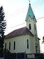 Lutheran church
 Polish elementary school
References
- ↑ "2001 census data". Czech Statistical Office.
- 1 2 3 Mrózek, Robert (1984). Nazwy miejscowe dawnego Śląska Cieszyńskiego [Local names of former Cieszyn Silesia] (in Polish). Katowice: Uniwersytet Śląski w Katowicach. p. 166. ISSN 0208-6336.
- ↑ Panic, Idzi (2010). Śląsk Cieszyński w średniowieczu (do 1528) [Cieszyn Silesia in the Middle Ages (until 1528)] (in Polish). Cieszyn: Starostwo Powiatowe w Cieszynie. p. 303. ISBN 978-83-926929-3-5.
- ↑ "Registrum denarii sancti Petri in archidiaconatu Opoliensi sub anno domini MCCCCXLVII per dominum Nicolaum Wolff decretorum doctorem, archidiaconum Opoliensem, ex commissione reverendi in Christo patris ac domini Conradi episcopi Wratislaviensis, sedis apostolice collectoris, collecti". Zeitschrift des Vereins für Geschichte und Alterthum Schlesiens (in German). Breslau: H. Markgraf. 27: 361–372. 1893. Retrieved 21 July 2014.
- ↑ Broda, Jan (1992). "Materiały do dziejów Kościoła ewangelickiego w Księstwie Cieszyńskim i Państwie Pszczyńskim w XVI i XVII wieku". Z historii Kościoła ewangelickiego na Śląsku Cieszyńskim (in Polish). Katowice: Dom Wydawniczy i Księgarski „Didache“. pp. 259–260. ISBN 83-85572-00-7.
- ↑ Piątkowski, Kazimierz (1918). Stosunki narodowościowe w Księstwie Cieszyńskiem (in Polish). Cieszyn: Macierz Szkolna Księstwa Cieszyńskiego. pp. 274, 291.
- ↑ "Ustawa z dnia 27 października 1938 r. o podziale administracyjnym i tymczasowej organizacji administracji na obszarze Ziem Odzyskanych Śląska Cieszyńskiego". Dziennik Ustaw Śląskich (in Polish). Katowice. nr 18/1938, poz. 35. 31 October 1938. Retrieved 1 July 2014.
Further reading
- Rudnik, Czesława (February 2009). "Stonawskie memento". Zwrot: 8–10.
External links
| Wikimedia Commons has media related to Stonava. |
- (Czech) Official website

Coordinates: 49°48′44″N 18°31′50″E / 49.81222°N 18.53056°E