Stolac
| Stolac Столац | |||
|---|---|---|---|
.jpg) | |||
| |||
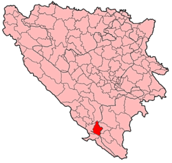 Location of Stolac Municipality within Bosnia and Herzegovina. | |||
| Country |
| ||
| Entity |
| ||
| Government | |||
| • Municipality president | Stjepan Bošković (HDZ BiH) | ||
| Area | |||
| • Total | 331 km2 (128 sq mi) | ||
| Population (2013 census) | |||
| • Total | 14,889 | ||
| • Density | 45/km2 (120/sq mi) | ||
| Time zone | CET (UTC+1) | ||
| • Summer (DST) | CEST (UTC+2) | ||
| Area code(s) | +387 36 | ||
| Website | http://www.stolac.gov.ba | ||


Stolac is a town and municipality in Bosnia and Herzegovina, located in Herzegovina. Administratively, it is part of the Herzegovina-Neretva Canton in the Federation of Bosnia and Herzegovina. Stolac is situated in the area known as Herzegovina Humina, on the tourist route crossing Herzegovina and linking the Bosnian mountainous hinterland with the coastal regions of Bosnia and Herzegovina, Dubrovnik and Montenegro. The road, running from Sarajevo via Mostar, Stolac, Ljubinje and Trebinje, enables one to reach Dubrovnik in less than 4 hours. Thanks to the town's favourable natural environment - geological composition, contours, climate, hydrographic and vegetation - Stolac and its area have been settled since ancient times. Its rich hunting-grounds along with other natural benefits attracted prehistoric man, and later the Illyrians, Romans and Slavs, all of whom left a wealth of anthropological evidence.[1]
History
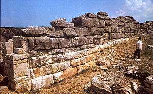
The area has been settled for at least 15,000 years, as evidenced by the markings in Badanj Cave, which experts have dated 12,000 - 16,000 BCE. Three kilometers west of Stolac is an impressive stećak necropolis dating back to the 15th and 16th centuries: Radimlja. These stećak tombstones are carved with epitaphs, detailed portraits of the deceased, and motifs such as grape vines, hunting scenes, and wild animals. Five of the Radimlja tombstones are thought to mark the graves of members of the Hrabren Miloradović family.
Ali-paša Rizvanbegović (1783-1851), the semi-independent ruler (vizier) of Ottoman Herzegovina from 1833 to 1851, was born in the Begovina neighbourhood of Stolac.
Architecture
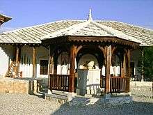
Containing, in one small area, unique cultural and aesthetic values, Stolac's historic core is an example of a complex cultural-historical and natural environmental ensemble. It is an example of the organic connection between human and natural architectures, which also testifies to the fact that the beauty of the location was crucial in its building and planning - the guiding principle often present in the development of mediaeval towns. Nine historical layers compose Stolac's architectural ensemble: pre-history, Illyrian-Roman period, the early Middle Ages, advanced and late Middle Ages, Ottoman period, Austro-Hungarian period, and the time of the first and second Yugoslavia. A multitude of various influences on the architecture of town, in which contrasts and similarities are frequently evident as well as planning and full spontaneity, lend this town a complex image.
Despite its unusual history and inclusion into four empires (Roman, Byzantine, Ottoman, and Austro-Hungarian), three kingdoms (Bosnian, Hungarian and Yugoslav), three world's monotheistic religions - Christianity (Orthodox Christianity and Catholicism), Islam, and Judaism, the historical core of Stolac is still a coherent and harmonious cultural-historical monument with individual properties grown together into one ensemble.[2]
Tourist attractions
Notable people
- Jezzar Pasha, Ottoman governor
- Mak Dizdar, poet
- Ali-paša Rizvanbegović, administrator of Stolac from 1813 to 1833
- Asaf Duraković, physician and poet
- Zdravko Šotra, film director
- Alija Isaković, writer, publicist and playwright
- Muhamed Mehmedbašić, member of Young Bosnia
- Salmir Kaplan, Minister of Culture and Sports in Bosnia and Herzegovina
- Mustafa Golubić, member of Young Bosnia
Demographics
| year of census | total | Bosniaks | Croats | Serbs | Yugoslavs | others |
|---|---|---|---|---|---|---|
| 1971 | 19,230 | 7,113 (36.98%) | 7,041 (36.61%) | 4,900 (25.48%) | 63 (0.32%) | 113 (0.58%) |
| 1981 | 18,910 | 7,359 (38.91%) | 6,410 (33.89%) | 4,332 (22.90%) | 675 (3.56%) | 134 (0.70%) |
| 1991 | 18,681 | 8,101 (43.36%) | 6,188 (33.12%) | 3,917 (20.96%) | 307 (1.64%) | 168 (0.89%) |
Settlements of Stolac municipality, 1991.
Aladinići, Barane, Berkovići, Bitunja, Bjelojevići, Borojevići, Brštanik, Burmazi, Crnići-Greda, Crnići-Kula, Dabrica, Do, Hatelji, Hodovo, Hrgud, Komanje Brdo, Kozice, Kruševo, Ljubljenica, Ljuti Do, Meča, Orahovica, Ošanići, Pješivac-Greda, Pješivac-Kula, Poplat, Poprati, Predolje, Prenj, Rotimlja, Stolac, Strupići, Suzina, Šćepan Krst, Trijebanj, Trusina and Žegulja.
In former municipality of Stolac from 1991. census, today there is two municipalities: Stolac in Federation of Bosnia and Herzegovina and Berkovići in Republika Srpska.
Climate
Climate in this area has mild differences between highs and lows, and there is adequate rainfall year round. The Köppen Climate Classification subtype for this climate is "Cfb" (Marine West Coast Climate/Oceanic climate).[3]
| Climate data for Stolac | |||||||||||||
|---|---|---|---|---|---|---|---|---|---|---|---|---|---|
| Month | Jan | Feb | Mar | Apr | May | Jun | Jul | Aug | Sep | Oct | Nov | Dec | Year |
| Average high °C (°F) | 9 (48) |
11 (51) |
15 (59) |
19 (67) |
24 (75) |
29 (85) |
33 (92) |
33 (91) |
28 (82) |
22 (71) |
16 (60) |
9 (49) |
21 (69) |
| Average low °C (°F) | 3 (37) |
2 (36) |
6 (43) |
9 (48) |
13 (55) |
17 (62) |
19 (66) |
19 (66) |
16 (61) |
12 (54) |
9 (48) |
4 (39) |
11 (51) |
| Average precipitation cm (inches) | 13 (5) |
11.9 (4.7) |
13.2 (5.2) |
13.2 (5.2) |
7.9 (3.1) |
8.4 (3.3) |
4.8 (1.9) |
4.3 (1.7) |
10 (4) |
16.5 (6.5) |
18.5 (7.3) |
18.3 (7.2) |
140 (55.1) |
| Source: Weatherbase [4] | |||||||||||||
References
- ↑ The natural and architectural ensemble of Stolac, unesco.org; accessed 4 November 2016.
- ↑ The natural and architectural ensemble of Stolac, unesco.org; accessed 4 November 2016.
- ↑ Climate Summary for Stolac
- ↑ "Weatherbase.com". Weatherbase. 2013. Retrieved on July 13, 2013.
External links
| Wikimedia Commons has media related to Stolac. |
Municipalities of the Herzegovina-Neretva Canton | ||
|---|---|---|
Coordinates: 43°05′02″N 17°57′33″E / 43.08389°N 17.95917°E
| Wikimedia Commons has media related to Stolac. |