Stateburg, South Carolina
| Stateburg, South Carolina | |
|---|---|
| CDP | |
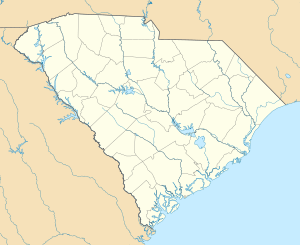 Stateburg, South Carolina Location within the state of South Carolina | |
| Coordinates: 33°58′43″N 80°31′30″W / 33.97861°N 80.52500°WCoordinates: 33°58′43″N 80°31′30″W / 33.97861°N 80.52500°W | |
| Country | United States |
| State | South Carolina |
| County | Sumter |
| Area | |
| • Total | 4.7 sq mi (12.2 km2) |
| • Land | 4.7 sq mi (12.1 km2) |
| • Water | 0.0 sq mi (0.1 km2) |
| Elevation | 305 ft (93 m) |
| Population (2000) | |
| • Total | 1,264 |
| • Density | 270.3/sq mi (104.4/km2) |
| Time zone | Eastern (EST) (UTC-5) |
| • Summer (DST) | EDT (UTC-4) |
| ZIP code | 29150 |
| Area code(s) | 803 |
| FIPS code | 45-69010[1] |
| GNIS feature ID | 1251031[2] |
Stateburg is a census-designated place (CDP) in the High Hills of Santee in Sumter County, South Carolina, United States. The population was 1,380 at the 2010 census. It is included in the Sumter, South Carolina Metropolitan Statistical Area. Stateburg is located within the larger Stateburg Historic District.
History
In the 1780s, after the South Carolina General Assembly decided to move the state capital from Charleston to the central part of the state, Stateburg lost by only a few votes to a place called Granby's Ferry on the Congaree River near the confluence of the Broad and Saluda rivers. Granby's Ferry soon was renamed Columbia, which is still the capital.
In 1785 Stateburg became the county seat of Claremont County and served as such until Claremont County was dissolved in 1800.[3]
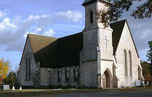
Borough House Plantation and Church of the Holy Cross are listed on the National Register of Historic Places.[4]
Geography
Stateburg is located at 33°58′43″N 80°31′30″W / 33.97861°N 80.52500°W (33.978524, -80.524951).[5]
According to the United States Census Bureau, the CDP has a total area of 4.7 square miles (12.2 km²), of which, 4.7 square miles (12.1 km²) of it is land and 0.04 square miles (0.1 km²) of it (0.43%) is water.
Demographics
As of the census[1] of 2000, there were 1,264 people, 461 households, and 389 families residing in the CDP. The population density was 270.3 people per square mile (104.3/km²). There were 477 housing units at an average density of 102.0/sq mi (39.4/km²). The racial makeup of the CDP was 72.55% White, 22.71% African American, 0.55% Native American, 2.06% Asian, 0.08% Pacific Islander, 0.32% from other races, and 1.74% from two or more races. Hispanic or Latino of any race were 2.69% of the population.
There were 461 households out of which 38.6% had children under the age of 18 living with them, 73.5% were married couples living together, 6.5% had a female householder with no husband present, and 15.6% were non-families. 13.2% of all households were made up of individuals and 2.2% had someone living alone who was 65 years of age or older. The average household size was 2.74 and the average family size was 2.99.
In the CDP the population was spread out with 26.8% under the age of 18, 6.6% from 18 to 24, 30.1% from 25 to 44, 29.9% from 45 to 64, and 6.6% who were 65 years of age or older. The median age was 38 years. For every 100 females there were 98.7 males. For every 100 females age 18 and over, there were 96.4 males.
The median income for a household in the CDP was $59,152, and the median income for a family was $59,196. Males had a median income of $42,431 versus $26,875 for females. The per capita income for the CDP was $23,617. None of the families and 1.2% of the population were living below the poverty line, including no under eighteens and 7.9% of those over 64.
Notable residents
- Richard H. Anderson, born in Stateburg, Confederate Army general[6]
- Mary Boykin Chesnut, born in Stateburg, daughter of Stephen Decatur Miller. Her noted diary chronicled life in the South during the Civil War.
- Stephen Decatur Miller, U.S. Congressman, state Governor, and U.S. Senator
- Thomas Sumter, American Revolutionary War general.
- William Ellison, Cotton Gin maker and freed slave turned slave owner.
References
- 1 2 "American FactFinder". United States Census Bureau. Retrieved 2008-01-31.
- ↑ "US Board on Geographic Names". United States Geological Survey. 2007-10-25. Retrieved 2008-01-31.
- ↑ History of Claremont County, SC
- ↑ National Park Service (2010-07-09). "National Register Information System". National Register of Historic Places. National Park Service.
- ↑ "US Gazetteer files: 2010, 2000, and 1990". United States Census Bureau. 2011-02-12. Retrieved 2011-04-23.
- ↑ Who Was Who in America, Historical Volume, 1607-1896. Marquis Who's Who. 1967.
External links
| Wikimedia Commons has media related to Stateburg, South Carolina. |
Municipalities and communities of Sumter County, South Carolina, United States | ||
|---|---|---|
| City |  | |
| Towns | ||
| CDPs | ||
| Unincorporated communities | ||