Virginia State Route 223
For the former State Route 223, see State Route 223 (Virginia pre-1933).
| ||||
|---|---|---|---|---|
| Cricket Hill Road | ||||
 | ||||
| Route information | ||||
| Maintained by VDOT | ||||
| Length: | 2.07 mi[1] (3.33 km) | |||
| Existed: | 1933 – present | |||
| Major junctions | ||||
| South end: |
| |||
| North end: |
| |||
| Location | ||||
| Counties: | Mathews | |||
| Highway system | ||||
| ||||

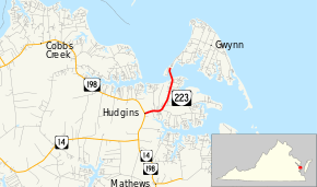
State Route 223 (SR 223) is a primary state highway in the U.S. state of Virginia. Known as Cricket Hill Road, the state highway runs 2.07 miles (3.33 km) from SR 198 at Hudgins north to SR 633 on Gwynn's Island, an island at the mouth of the Piankatank River in northeastern Mathews County.
Route description
SR 223 begins at an intersection with SR 198 (Buckley Hall Road) at Hudgins. The state highway heads east and curves north through Cricket Hill. North of Cricket Hill, SR 223 crosses Milford Haven, a channel that separates Gwynn's Island from the mainland, and reaches its northern terminus at SR 633 (Old Ferry Road). SR 633 continues northeast through the island's settlements of Grimstead and Gwynn.[1][2]
Major intersections
The entire route is in Mathews County.
| Location | mi[1] | km | Destinations | Notes | |
|---|---|---|---|---|---|
| Hudgins | 0.00 | 0.00 | |||
| Gwynn's Island | 2.07 | 3.33 | |||
| 1.000 mi = 1.609 km; 1.000 km = 0.621 mi | |||||
References
- 1 2 3 "2010 Traffic Data". Virginia Department of Transportation. 2010. Retrieved 2011-12-08.
- Mathews County (PDF)
- ↑ Google (2011-12-08). "Virginia State Route 223" (Map). Google Maps. Google. Retrieved 2011-12-08.
External links
| < SR 628 | District 6 State Routes 1928–1933 |
SR 630 > |
This article is issued from Wikipedia - version of the 11/12/2016. The text is available under the Creative Commons Attribution/Share Alike but additional terms may apply for the media files.